Property Record
58890 Carnation Rd, Olathe, CO 81425
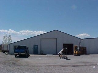

Property Detail
58890 Carnation Rd
R0650087
SUBD: BROUGHTON CELLARS SUBD LOT: 11 S: 4 T: 50 R: 10
Warehouse
MONTROSE
B and X Area of moderate flood hazard, usually the area between the limits of the 100-year and 500-year floods.
Colorado
2025
13.70 AC
2025
Colorado Southwest Area
966202
Other Market Areas
6,270 SF
Montrose, CO
NEARBY LISTINGS FOR SALE OR LEASE
DEMOGRAPHICS near 58890 Carnation Rd
1 mile
3 mile
5 mile
2025 Total Population
134
2,505
5,680
2030 Population
140
2,516
5,858
Pop Growth 2025-2030
+ 4.48%
+ 0.44%
+ 3.13%
Average Age
43
41
42
2025 Total Households
47
815
2,006
HH Growth 2025-2030
+ 4.26%
+ 0.49%
+ 3.39%
Median Household Inc
$81,250
$75,972
$77,106
Avg Household Size
2.70
2.70
2.60
2025 Avg HH Vehicles
3.00
2.00
2.00
Median Home Value
$589,286
$319,117
$373,541
Median Year Built
1994
1984
1990
Nearby Places
Map Layers
Map Styles
 Street
 Aerial
Transit
 Traffic
 Biking
Places
Listings with unknown addresses are not visible on the map
- Restaurants
- Banks
- Shops
- Fitness
- Groceries
PUBLIC TRANSPORTATION
AIRPORT
Montrose Regional
Drive
Walk
Distance
Montrose Regional
18 min
10.5 mi
Nearby Properties
Address
Land Use
TOTAL SIZE
Lot Size
Zoning
Address
Land Use
TOTAL SIZE
Lot Size
Zoning
64,279 SF
23.86 AC
Address
Land Use
TOTAL SIZE
Lot Size
Zoning
25,139 SF
6.02 AC
Address
Land Use
TOTAL SIZE
Lot Size
Zoning
8,898 SF
9.88 AC
Address
Land Use
TOTAL SIZE
Lot Size
Zoning
76,442 SF
42.59 AC
Address
Land Use
TOTAL SIZE
Lot Size
Zoning
4,085 SF
0.25 AC
Address
Land Use
TOTAL SIZE
Lot Size
Zoning
20,400 SF
5.63 AC
Address
Land Use
TOTAL SIZE
Lot Size
Zoning
24,012 SF
6.88 AC
Address
Land Use
TOTAL SIZE
Lot Size
Zoning
9,236 SF
1.39 AC
Address
Land Use
TOTAL SIZE
Lot Size
Zoning
13,720 SF
2.28 AC
Address
Land Use
TOTAL SIZE
Lot Size
Zoning
3,392 SF
2.34 AC
Address
Land Use
TOTAL SIZE
Lot Size
Zoning
9,705 SF
4.25 AC
Address
Land Use
TOTAL SIZE
Lot Size
Zoning
8,965 SF
2 AC
Address
Land Use
TOTAL SIZE
Lot Size
Zoning
6,346 SF
3.30 AC
Address
Land Use
TOTAL SIZE
Lot Size
Zoning
12,450 SF
10.33 AC
Address
Land Use
TOTAL SIZE
Lot Size
Zoning
4,927 SF
1.35 AC
Address
Land Use
TOTAL SIZE
Lot Size
Zoning
5,814 SF
0.73 AC
Address
Land Use
TOTAL SIZE
Lot Size
Zoning
9,465 SF
5.41 AC
Address
Land Use
TOTAL SIZE
Lot Size
Zoning
35,553 SF
8.91 AC
Address
Land Use
TOTAL SIZE
Lot Size
Zoning
11,808 SF
37.61 AC
Address
Land Use
TOTAL SIZE
Lot Size
Zoning
22,350 SF
2 AC
Address
Land Use
TOTAL SIZE
Lot Size
Zoning
5,000 SF
5.60 AC
Address
Land Use
TOTAL SIZE
Lot Size
Zoning
7,600 SF
11.68 AC
Address
Land Use
TOTAL SIZE
Lot Size
Zoning
3,780 SF
0.65 AC
Address
Land Use
TOTAL SIZE
Lot Size
Zoning
7,470 SF
0.36 AC
Address
Land Use
TOTAL SIZE
Lot Size
Zoning
2,400 SF
98.78 AC
Address
Land Use
TOTAL SIZE
Lot Size
Zoning
6,600 SF
22.04 AC
Address
Land Use
TOTAL SIZE
Lot Size
Zoning
5,000 SF
40 AC
Address
Land Use
TOTAL SIZE
Lot Size
Zoning
6,000 SF
0.14 AC
Address
Land Use
TOTAL SIZE
Lot Size
Zoning
5,000 SF
5.97 AC
Address
Land Use
TOTAL SIZE
Lot Size
Zoning
2,400 SF
1.10 AC
The World's #1 Commercial Real Estate Marketplace
Connect with us
© 2026 CoStar Group
The information above has been obtained from sources believed reliable. While we do not doubt its accuracy we have not verified it and make no guarantee, warranty or representation about it. It is your responsibility to independently confirm its accuracy and completeness. Any projections, opinions, assumptions, or estimates used are for example only and do not represent the current or future performance of the property. The value of this transaction to you depends on tax and other factors which should be evaluated by your tax, financial, and legal advisors. You and your advisors should conduct a careful, independent investigation of the property to determine to your satisfaction the suitability of the property for your needs.