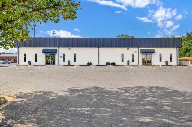
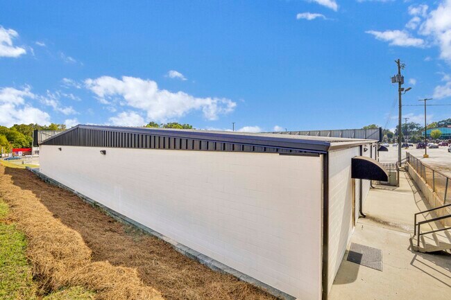
Property Record
589 Bessemer Super Hwy, Birmingham, AL 35228

NEARBY LISTINGS FOR SALE OR LEASE
Property Detail
589 Bessemer Super Hwy
Birmingham, AL
Woodfield Square
30-00-23-4-008-006.000
LOT 1 WOODFIELD SQUARE 23/60
Officebuilding
Jefferson
X
Alabama
01073C0533G
1
2024
0.69 AC
2024
Bessemer
013601
Birmingham
10,000 SF
DEMOGRAPHICS near 589 Bessemer Super Hwy
1 Mile
3 Mile
5 Mile
2024 Total Population
6,100
42,053
117,109
2029 Population
6,030
41,907
116,562
Pop Growth 2024-2029
(1.15%)
(0.35%)
(0.47%)
Average Age
41
41
40
2024 Total Households
2,469
17,130
48,438
HH Growth 2024-2029
(1.22%)
(0.48%)
(0.56%)
Median Household Inc
$49,380
$41,602
$41,735
Avg Household Size
2.50
2.30
2.30
2024 Avg HH Vehicles
2.00
2.00
2.00
Median Home Value
$121,324
$83,877
$99,374
Median Year Built
1966
1961
1965
Nearby Places
Map Layers
Map Styles
 Street
 Aerial
- Restaurants
- Banks
- Shops
- Fitness
- Groceries
PUBLIC TRANSPORTATION
COMMUTER RAIL
Birmingham (Crescent - Amtrak)
DRIVE
WALK
Distance
Birmingham (Crescent - Amtrak)
14 min
8.8 mi
AIRPORT
Birmingham-Shuttlesworth International
DRIVE
WALK
Distance
Birmingham-Shuttlesworth International
22 min
13.9 mi
Freight Ports
Port of Mobile
DRIVE
WALK
Distance
Port of Mobile
287 min
242.8 mi
SALE & LEASE HISTORY
LISTING DATE
SALE/LEASE

May 02, 2024
For Sale
Apr 08, 2022
For Sale
Nearby Properties
Address
Land Use
TOTAL SIZE
Lot Size
Zoning
Address
Land Use
TOTAL SIZE
Lot Size
Zoning
321,783 SF
19.40 AC
MXD
Address
Land Use
TOTAL SIZE
Lot Size
Zoning
1,244,986 SF
I2
Address
Land Use
TOTAL SIZE
Lot Size
Zoning
120,238 SF
10 AC
I3
Address
Land Use
TOTAL SIZE
Lot Size
Zoning
2,573,547 SF
112 AC
I2
Address
Land Use
TOTAL SIZE
Lot Size
Zoning
460,483 SF
20 AC
I3
Address
Land Use
TOTAL SIZE
Lot Size
Zoning
96,446 SF
10 AC
I3
Address
Land Use
TOTAL SIZE
Lot Size
Zoning
202,775 SF
10.40 AC
I3
Address
Land Use
TOTAL SIZE
Lot Size
Zoning
200,650 SF
19.48 AC
R4
Address
Land Use
TOTAL SIZE
Lot Size
Zoning
195,495 SF
28.97 AC
B3
Address
Land Use
TOTAL SIZE
Lot Size
Zoning
73,033 SF
15.20 AC
R-6
Address
Land Use
TOTAL SIZE
Lot Size
Zoning
191,664 SF
14.73 AC
R4
Address
Land Use
TOTAL SIZE
Lot Size
Zoning
145,300 SF
25 AC
R3
Address
Land Use
TOTAL SIZE
Lot Size
Zoning
48,320 SF
7.81 AC
I3
Address
Land Use
TOTAL SIZE
Lot Size
Zoning
288,000 SF
39.40 AC
I2-I
Address
Land Use
TOTAL SIZE
Lot Size
Zoning
46,155 SF
0.77 AC
R4
Address
Land Use
TOTAL SIZE
Lot Size
Zoning
230,088 SF
I3
Address
Land Use
TOTAL SIZE
Lot Size
Zoning
101,671 SF
14.73 AC
B2
Address
Land Use
TOTAL SIZE
Lot Size
Zoning
114,345 SF
11.20 AC
I-3
Address
Land Use
TOTAL SIZE
Lot Size
Zoning
218,210 SF
11.24 AC
CM-2
Address
Land Use
TOTAL SIZE
Lot Size
Zoning
29,906 SF
5.40 AC
I3
Address
Land Use
TOTAL SIZE
Lot Size
Zoning
77,902 SF
44 AC
I3
Address
Land Use
TOTAL SIZE
Lot Size
Zoning
69,344 SF
2.30 AC
B-1
Address
Land Use
TOTAL SIZE
Lot Size
Zoning
26,234 SF
3.30 AC
B2
Address
Land Use
TOTAL SIZE
Lot Size
Zoning
157,183 SF
6.50 AC
B2
Address
Land Use
TOTAL SIZE
Lot Size
Zoning
104,775 SF
9.40 AC
B-2
Address
Land Use
TOTAL SIZE
Lot Size
Zoning
1,437,077 SF
I2
Address
Land Use
TOTAL SIZE
Lot Size
Zoning
163,056 SF
I-3
Address
Land Use
TOTAL SIZE
Lot Size
Zoning
3,644 SF
10.60 AC
CM2
Address
Land Use
TOTAL SIZE
Lot Size
Zoning
45,666 SF
3.46 AC
R5
Address
Land Use
TOTAL SIZE
Lot Size
Zoning
96,543 SF
8.80 AC
B2
The World's #1 Commercial Real Estate Marketplace
Connect with us
© 2026 CoStar Group
The information above has been obtained from sources believed reliable. While we do not doubt its accuracy we have not verified it and make no guarantee, warranty or representation about it. It is your responsibility to independently confirm its accuracy and completeness. Any projections, opinions, assumptions, or estimates used are for example only and do not represent the current or future performance of the property. The value of this transaction to you depends on tax and other factors which should be evaluated by your tax, financial, and legal advisors. You and your advisors should conduct a careful, independent investigation of the property to determine to your satisfaction the suitability of the property for your needs.