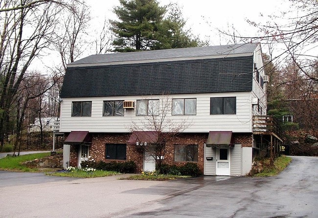
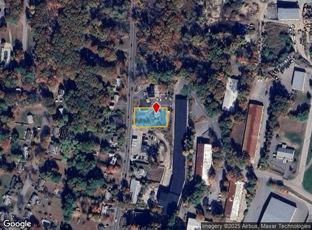
Property Record
589 Concord St, Holliston, MA 01746
NEARBY LISTINGS FOR SALE OR LEASE
Property Detail
589 Concord St
HOLL-000014-000004-000070
Middlesex
Officebuilding
Massachusetts
X
70
25017C0631G
0.50 AC
2025
Hopkinton/Holliston
2025
Boston
387201
Boston-Cambridge-Newton, MA-NH
4,032 SF
DEMOGRAPHICS near 589 Concord St
1 Mile
3 Mile
5 Mile
2024 Total Population
6,183
33,613
109,547
2029 Population
6,152
33,181
109,048
Pop Growth 2024-2029
(0.50%)
(1.29%)
(0.46%)
Average Age
42
41
40
2024 Total Households
2,356
12,132
40,902
HH Growth 2024-2029
(0.64%)
(1.36%)
(0.53%)
Median Household Inc
$110,861
$123,842
$110,039
Avg Household Size
2.60
2.70
2.60
2024 Avg HH Vehicles
2.00
2.00
2.00
Median Home Value
$476,246
$525,864
$613,879
Median Year Built
1977
1970
1973
Nearby Places
Map Layers
Map Styles
 Street
 Aerial
- Restaurants
- Banks
- Shops
- Fitness
- Groceries
PUBLIC TRANSPORTATION
COMMUTER RAIL
Framingham Amtrak (Lake Shore Limited - Amtrak)
DRIVE
WALK
Distance
Framingham Amtrak (Lake Shore Limited - Amtrak)
6 min
3.5 mi
Framingham (Framingham/Worcester Line - Massachusetts Bay Transportation Authority Commuter Rail (Purple Line))
DRIVE
WALK
Distance
Framingham (Framingham/Worcester Line - Massachusetts Bay Transportation Authority Commuter Rail (Purple Line))
6 min
3.5 mi
AIRPORT
Worcester Regional
DRIVE
WALK
Distance
Worcester Regional
48 min
27.6 mi
General Edward Lawrence Logan International
DRIVE
WALK
Distance
General Edward Lawrence Logan International
44 min
28.3 mi
Freight Ports
Port of Boston
DRIVE
WALK
Distance
Port of Boston
42 min
26.6 mi
Nearby Properties
Address
Land Use
TOTAL SIZE
Lot Size
Zoning
Address
Land Use
TOTAL SIZE
Lot Size
Zoning
315,055 SF
40.38 AC
G
Address
Land Use
TOTAL SIZE
Lot Size
Zoning
108.84 AC
M
Address
Land Use
TOTAL SIZE
Lot Size
Zoning
139,356 SF
52 AC
30
Address
Land Use
TOTAL SIZE
Lot Size
Zoning
154,724 SF
39.70 AC
G
Address
Land Use
TOTAL SIZE
Lot Size
Zoning
42,000 SF
3.82 AC
30
Address
Land Use
TOTAL SIZE
Lot Size
Zoning
75,224 SF
4.05 AC
I
Address
Land Use
TOTAL SIZE
Lot Size
Zoning
90,256 SF
14.48 AC
R4
Address
Land Use
TOTAL SIZE
Lot Size
Zoning
226,884 SF
6.16 AC
WMUSD
Address
Land Use
TOTAL SIZE
Lot Size
Zoning
169,461 SF
32.30 AC
40
Address
Land Use
TOTAL SIZE
Lot Size
Zoning
71,070 SF
1.66 AC
R4
Address
Land Use
TOTAL SIZE
Lot Size
Zoning
85,380 SF
15.02 AC
R4
Address
Land Use
TOTAL SIZE
Lot Size
Zoning
237,660 SF
20.98 AC
I
Address
Land Use
TOTAL SIZE
Lot Size
Zoning
71,500 SF
3.40 AC
30
Address
Land Use
TOTAL SIZE
Lot Size
Zoning
134.63 AC
A
Address
Land Use
TOTAL SIZE
Lot Size
Zoning
40,000 SF
26.63 AC
30
Address
Land Use
TOTAL SIZE
Lot Size
Zoning
58,053 SF
22.07 AC
R4
Address
Land Use
TOTAL SIZE
Lot Size
Zoning
99,368 SF
10.07 AC
30
Address
Land Use
TOTAL SIZE
Lot Size
Zoning
114,492 SF
21.70 AC
30
Address
Land Use
TOTAL SIZE
Lot Size
Zoning
44,235 SF
69.50 AC
40
Address
Land Use
TOTAL SIZE
Lot Size
Zoning
53,945 SF
11.47 AC
C
Address
Land Use
TOTAL SIZE
Lot Size
Zoning
291,513 SF
4.79 AC
30
Address
Land Use
TOTAL SIZE
Lot Size
Zoning
40,000 SF
28 AC
30
Address
Land Use
TOTAL SIZE
Lot Size
Zoning
43,950 SF
4.02 AC
R4
Address
Land Use
TOTAL SIZE
Lot Size
Zoning
46,904 SF
1.42 AC
R4
Address
Land Use
TOTAL SIZE
Lot Size
Zoning
29,484 SF
0.73 AC
R4
Address
Land Use
TOTAL SIZE
Lot Size
Zoning
84,000 SF
15.46 AC
I
Address
Land Use
TOTAL SIZE
Lot Size
Zoning
26,485 SF
65.37 AC
R4
Address
Land Use
TOTAL SIZE
Lot Size
Zoning
32,274 SF
0.70 AC
R4
Address
Land Use
TOTAL SIZE
Lot Size
Zoning
113,516 SF
7.94 AC
I
Address
Land Use
TOTAL SIZE
Lot Size
Zoning
2,304 SF
12.31 AC
C
The World's #1 Commercial Real Estate Marketplace
Connect with us
© 2025 CoStar Group
The information above has been obtained from sources believed reliable. While we do not doubt its accuracy we have not verified it and make no guarantee, warranty or representation about it. It is your responsibility to independently confirm its accuracy and completeness. Any projections, opinions, assumptions, or estimates used are for example only and do not represent the current or future performance of the property. The value of this transaction to you depends on tax and other factors which should be evaluated by your tax, financial, and legal advisors. You and your advisors should conduct a careful, independent investigation of the property to determine to your satisfaction the suitability of the property for your needs.