Property Record
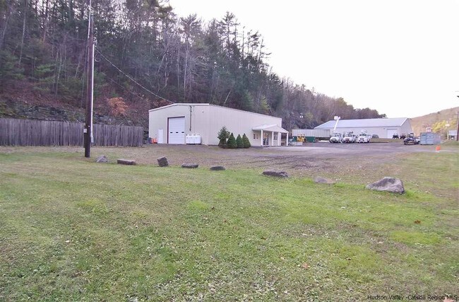
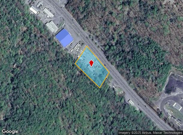
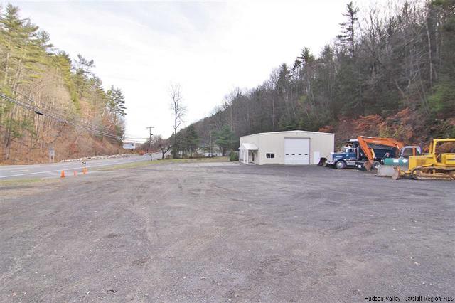
589 State Route 28, Kingston, NY 12401
NEARBY LISTINGS FOR SALE OR LEASE
Property Detail
589 State Route 28
5400-047.002-0003-024.200-0000
Ulster
Vehiclerentalsvehiclesales
New York
X
24.200
36111C0455F
1.50 AC
2025
Hudson Valley Area
2024
Other Market Areas
951500
Kingston, NY
2,400 SF
DEMOGRAPHICS near 589 State Route 28
1 Mile
3 Mile
5 Mile
2024 Total Population
112
6,030
38,992
2029 Population
113
6,052
38,965
Pop Growth 2024-2029
+ 0.89%
+ 0.36%
(0.07%)
Average Age
44
45
44
2024 Total Households
48
2,680
16,643
HH Growth 2024-2029
0.00%
+ 0.34%
(0.04%)
Median Household Inc
$82,692
$83,611
$75,416
Avg Household Size
2.40
2.20
2.20
2024 Avg HH Vehicles
2.00
2.00
2.00
Median Home Value
$289,999
$282,465
$279,055
Median Year Built
1978
1972
1958
Nearby Places
- Restaurants
- Banks
- Shops
- Fitness
- Groceries
SALE & LEASE HISTORY
LISTING DATE
SALE/LEASE

Sep 06, 2017
For Sale
Nearby Properties
Address
Land Use
TOTAL SIZE
Lot Size
Zoning
Address
Land Use
TOTAL SIZE
Lot Size
Zoning
135,158 SF
31.80 AC
R-1
Address
Land Use
TOTAL SIZE
Lot Size
Zoning
152,723 SF
9.60 AC
SD
Address
Land Use
TOTAL SIZE
Lot Size
Zoning
23.30 AC
37
Address
Land Use
TOTAL SIZE
Lot Size
Zoning
10,124 SF
7.50 AC
SD
Address
Land Use
TOTAL SIZE
Lot Size
Zoning
51,508 SF
34.50 AC
Address
Land Use
TOTAL SIZE
Lot Size
Zoning
77.80 AC
37
Address
Land Use
TOTAL SIZE
Lot Size
Zoning
29,964 SF
5.90 AC
SD
Address
Land Use
TOTAL SIZE
Lot Size
Zoning
6,564 SF
2.70 AC
30
Address
Land Use
TOTAL SIZE
Lot Size
Zoning
92,049 SF
1.90 AC
35
Address
Land Use
TOTAL SIZE
Lot Size
Zoning
12,771 SF
6.50 AC
SD
Address
Land Use
TOTAL SIZE
Lot Size
Zoning
2,544 SF
6.70 AC
37
Address
Land Use
TOTAL SIZE
Lot Size
Zoning
33,744 SF
1.80 AC
T4N-O
Address
Land Use
TOTAL SIZE
Lot Size
Zoning
32,000 SF
7.90 AC
35
Address
Land Use
TOTAL SIZE
Lot Size
Zoning
40,767 SF
4.65 AC
35
Address
Land Use
TOTAL SIZE
Lot Size
Zoning
18,260 SF
2 AC
T4N-O
Address
Land Use
TOTAL SIZE
Lot Size
Zoning
31,350 SF
5.40 AC
SD
Address
Land Use
TOTAL SIZE
Lot Size
Zoning
16,377 SF
4 AC
SD
Address
Land Use
TOTAL SIZE
Lot Size
Zoning
5,472 SF
14.80 AC
32
Address
Land Use
TOTAL SIZE
Lot Size
Zoning
1,460 SF
54.90 AC
A25
Address
Land Use
TOTAL SIZE
Lot Size
Zoning
960 SF
31.10 AC
R
Address
Land Use
TOTAL SIZE
Lot Size
Zoning
980 SF
54.37 AC
A4
Address
Land Use
TOTAL SIZE
Lot Size
Zoning
72,546 SF
6.14 AC
35
Address
Land Use
TOTAL SIZE
Lot Size
Zoning
14,821 SF
17.30 AC
T2C
Address
Land Use
TOTAL SIZE
Lot Size
Zoning
17,660 SF
5.10 AC
35
Address
Land Use
TOTAL SIZE
Lot Size
Zoning
3,096 SF
6.60 AC
H
Address
Land Use
TOTAL SIZE
Lot Size
Zoning
2,673 SF
78 AC
Address
Land Use
TOTAL SIZE
Lot Size
Zoning
3,750 SF
36.50 AC
R1
Address
Land Use
TOTAL SIZE
Lot Size
Zoning
6,958 SF
11.21 AC
35
Address
Land Use
TOTAL SIZE
Lot Size
Zoning
4,000 SF
126.50 AC
37
Address
Land Use
TOTAL SIZE
Lot Size
Zoning
58,500 SF
5.25 AC
35
The World's #1 Commercial Real Estate Marketplace
Connect with us
© 2025 CoStar Group
The information above has been obtained from sources believed reliable. While we do not doubt its accuracy we have not verified it and make no guarantee, warranty or representation about it. It is your responsibility to independently confirm its accuracy and completeness. Any projections, opinions, assumptions, or estimates used are for example only and do not represent the current or future performance of the property. The value of this transaction to you depends on tax and other factors which should be evaluated by your tax, financial, and legal advisors. You and your advisors should conduct a careful, independent investigation of the property to determine to your satisfaction the suitability of the property for your needs.