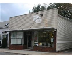
Property Record
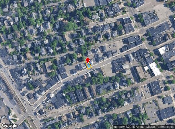
59 Albion St, Wakefield, MA 01880
NEARBY LISTINGS FOR SALE OR LEASE
Property Detail
59 Albion St
Storebuilding
Middlesex
X
Massachusetts
25009C0389G
0.06 AC
2025
Lynnfield/Wakefield
2025
Boston
335100
Boston-Cambridge-Newton, MA-NH
1,568 SF
WAKE-000012-000145-000147
DEMOGRAPHICS near 59 Albion St
1 Mile
3 Mile
5 Mile
2024 Total Population
13,782
89,086
231,021
2029 Population
13,579
88,003
228,753
Pop Growth 2024-2029
(1.47%)
(1.22%)
(0.98%)
Average Age
43
43
42
2024 Total Households
5,935
35,483
90,289
HH Growth 2024-2029
(1.55%)
(1.33%)
(1.07%)
Median Household Inc
$107,061
$119,352
$114,671
Avg Household Size
2.30
2.50
2.50
2024 Avg HH Vehicles
2.00
2.00
2.00
Median Home Value
$661,621
$702,142
$684,077
Median Year Built
1954
1958
1960
Nearby Places
Map Layers
Map Styles
 Street
 Aerial
- Restaurants
- Banks
- Shops
- Fitness
- Groceries
PUBLIC TRANSPORTATION
TRANSIT/SUBWAY
Wakefield (Haverhill Line - Massachusetts Bay Transportation Authority Commuter Rail (Purple Line))
DRIVE
WALK
Distance
Wakefield (Haverhill Line - Massachusetts Bay Transportation Authority Commuter Rail (Purple Line))
1 min
4 min
0.2 mi
COMMUTER RAIL
Wakefield (Haverhill Line - Massachusetts Bay Transportation Authority Commuter Rail (Purple Line))
DRIVE
WALK
Distance
Wakefield (Haverhill Line - Massachusetts Bay Transportation Authority Commuter Rail (Purple Line))
1 min
4 min
0.2 mi
Greenwood (Haverhill Line - Massachusetts Bay Transportation Authority Commuter Rail (Purple Line))
DRIVE
WALK
Distance
Greenwood (Haverhill Line - Massachusetts Bay Transportation Authority Commuter Rail (Purple Line))
4 min
1.6 mi
AIRPORT
General Edward Lawrence Logan International
DRIVE
WALK
Distance
General Edward Lawrence Logan International
24 min
14.2 mi
Manchester Boston Regional
DRIVE
WALK
Distance
Manchester Boston Regional
60 min
42.5 mi
Freight Ports
Port of Boston
DRIVE
WALK
Distance
Port of Boston
25 min
14.0 mi
SALE & LEASE HISTORY
LISTING DATE
SALE/LEASE

Oct 29, 2021
For Sale
Nearby Properties
Address
Land Use
TOTAL SIZE
Lot Size
Zoning
Address
Land Use
TOTAL SIZE
Lot Size
Zoning
14.97 AC
C
Address
Land Use
TOTAL SIZE
Lot Size
Zoning
213,401 SF
15.16 AC
B
Address
Land Use
TOTAL SIZE
Lot Size
Zoning
720 SF
632 AC
SA8
Address
Land Use
TOTAL SIZE
Lot Size
Zoning
31.56 AC
HB
Address
Land Use
TOTAL SIZE
Lot Size
Zoning
267,277 SF
60 AC
MD
Address
Land Use
TOTAL SIZE
Lot Size
Zoning
9.01 AC
S-I
Address
Land Use
TOTAL SIZE
Lot Size
Zoning
215,057 SF
12 AC
RB
Address
Land Use
TOTAL SIZE
Lot Size
Zoning
217,937 SF
8.40 AC
I
Address
Land Use
TOTAL SIZE
Lot Size
Zoning
153,906 SF
4 AC
S15
Address
Land Use
TOTAL SIZE
Lot Size
Zoning
228,797 SF
10.61 AC
MD
Address
Land Use
TOTAL SIZE
Lot Size
Zoning
172,056 SF
I
Address
Land Use
TOTAL SIZE
Lot Size
Zoning
5.63 AC
C
Address
Land Use
TOTAL SIZE
Lot Size
Zoning
8.17 AC
RB
Address
Land Use
TOTAL SIZE
Lot Size
Zoning
6.28 AC
RB
Address
Land Use
TOTAL SIZE
Lot Size
Zoning
216,337 SF
7.19 AC
S20
Address
Land Use
TOTAL SIZE
Lot Size
Zoning
9 AC
C/R
Address
Land Use
TOTAL SIZE
Lot Size
Zoning
14,760 SF
1 AC
SR
Address
Land Use
TOTAL SIZE
Lot Size
Zoning
11.06 AC
RB
Address
Land Use
TOTAL SIZE
Lot Size
Zoning
155,686 SF
2.88 AC
I
Address
Land Use
TOTAL SIZE
Lot Size
Zoning
262,220 SF
11.79 AC
Address
Land Use
TOTAL SIZE
Lot Size
Zoning
254,374 SF
34.70 AC
I
Address
Land Use
TOTAL SIZE
Lot Size
Zoning
5.09 AC
R-1
Address
Land Use
TOTAL SIZE
Lot Size
Zoning
141,827 SF
8.10 AC
S15
Address
Land Use
TOTAL SIZE
Lot Size
Zoning
167,470 SF
8.50 AC
B
Address
Land Use
TOTAL SIZE
Lot Size
Zoning
190,643 SF
38.88 AC
OS
Address
Land Use
TOTAL SIZE
Lot Size
Zoning
156,846 SF
11.79 AC
Address
Land Use
TOTAL SIZE
Lot Size
Zoning
5,763 SF
8.31 AC
O-P
Address
Land Use
TOTAL SIZE
Lot Size
Zoning
237,854 SF
7.98 AC
O-P
Address
Land Use
TOTAL SIZE
Lot Size
Zoning
210,452 SF
16.20 AC
NA
Address
Land Use
TOTAL SIZE
Lot Size
Zoning
252 AC
OS
The World's #1 Commercial Real Estate Marketplace
Connect with us
© 2025 CoStar Group
The information above has been obtained from sources believed reliable. While we do not doubt its accuracy we have not verified it and make no guarantee, warranty or representation about it. It is your responsibility to independently confirm its accuracy and completeness. Any projections, opinions, assumptions, or estimates used are for example only and do not represent the current or future performance of the property. The value of this transaction to you depends on tax and other factors which should be evaluated by your tax, financial, and legal advisors. You and your advisors should conduct a careful, independent investigation of the property to determine to your satisfaction the suitability of the property for your needs.