Property Record
59-705 Pupukea Rd, Haleiwa, HI 96712
NEARBY LISTINGS FOR SALE OR LEASE
-
-
View all Haleiwa listings for sale on LoopNet.com
Property Detail
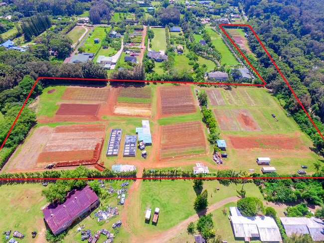
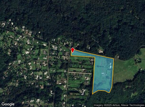
59-705 Pupukea Rd
Urban Honolulu, HI
Pot Lt 18 Pcr Lp Gr 518
1-5-9-031-028-0000
POR LOT 18 MAP 2252 16.134 AC DES TOG/UND 1/27 INT IN: RDWY LOT 28 (5931-29) V/O SUBJ/GR
Agriculturalland
Honolulu
D
Hawaii
15003C0020F
18,28
2024
16.13 AC
2025
North Shore
010101
Hawaii
6,448 SF
DEMOGRAPHICS near 59-705 Pupukea Rd
1 Mile
3 Mile
5 Mile
2024 Total Population
894
4,509
6,021
2029 Population
850
4,169
5,835
Pop Growth 2024-2029
(4.92%)
(7.54%)
(3.09%)
Average Age
40
40
41
2024 Total Households
293
1,438
2,048
HH Growth 2024-2029
(5.80%)
(8.69%)
(3.03%)
Median Household Inc
$73,880
$87,737
$83,451
Avg Household Size
3.00
3.00
2.80
2024 Avg HH Vehicles
3.00
2.00
2.00
Median Home Value
$1,147,414
$1,119,406
$1,062,210
Median Year Built
1984
1977
1977
Nearby Places
- Restaurants
- Banks
- Shops
- Fitness
- Groceries
PUBLIC TRANSPORTATION
AIRPORT
Daniel K Inouye International
DRIVE
WALK
Distance
Daniel K Inouye International
59 min
34.4 mi
Freight Ports
Honolulu Harbor, Oahu
DRIVE
WALK
Distance
Honolulu Harbor, Oahu
67 min
38.5 mi
SALE & LEASE HISTORY
LISTING DATE
SALE/LEASE

Aug 31, 2021
For Sale
Nearby Properties
Address
Land Use
TOTAL SIZE
Lot Size
Zoning
Address
Land Use
TOTAL SIZE
Lot Size
Zoning
7,000 SF
2,050 AC
AG-1
Address
Land Use
TOTAL SIZE
Lot Size
Zoning
1,754.59 AC
AG-1
Address
Land Use
TOTAL SIZE
Lot Size
Zoning
1,058.31 AC
AG-2
Address
Land Use
TOTAL SIZE
Lot Size
Zoning
449.72 AC
AG-2
Address
Land Use
TOTAL SIZE
Lot Size
Zoning
476.27 AC
AG-2
Address
Land Use
TOTAL SIZE
Lot Size
Zoning
519.36 AC
AG-2
Address
Land Use
TOTAL SIZE
Lot Size
Zoning
12.46 AC
AG-2
Address
Land Use
TOTAL SIZE
Lot Size
Zoning
5.51 AC
U/05/00
Address
Land Use
TOTAL SIZE
Lot Size
Zoning
212.60 AC
AG-2
Address
Land Use
TOTAL SIZE
Lot Size
Zoning
12,598 SF
1,794.57 AC
P-1
Address
Land Use
TOTAL SIZE
Lot Size
Zoning
3,904 SF
87.43 AC
AG-2
Address
Land Use
TOTAL SIZE
Lot Size
Zoning
21,643 SF
1.84 AC
B-1
Address
Land Use
TOTAL SIZE
Lot Size
Zoning
13,530 SF
11.01 AC
AG-2
Address
Land Use
TOTAL SIZE
Lot Size
Zoning
135.51 AC
AG-2
Address
Land Use
TOTAL SIZE
Lot Size
Zoning
3.72 AC
P-1
Address
Land Use
TOTAL SIZE
Lot Size
Zoning
960 SF
107.90 AC
AG-2
Address
Land Use
TOTAL SIZE
Lot Size
Zoning
1,898 SF
0.13 AC
R-5
Address
Land Use
TOTAL SIZE
Lot Size
Zoning
3,777 SF
17.66 AC
AG-2
Address
Land Use
TOTAL SIZE
Lot Size
Zoning
804 SF
224.26 AC
AG-2
Address
Land Use
TOTAL SIZE
Lot Size
Zoning
2.08 AC
P-1
Address
Land Use
TOTAL SIZE
Lot Size
Zoning
19,947 SF
27.44 AC
AG-2
Address
Land Use
TOTAL SIZE
Lot Size
Zoning
13.40 AC
AG-2
Address
Land Use
TOTAL SIZE
Lot Size
Zoning
2,419 SF
8.95 AC
AG-2
Address
Land Use
TOTAL SIZE
Lot Size
Zoning
11.09 AC
AG-2
Address
Land Use
TOTAL SIZE
Lot Size
Zoning
12.54 AC
AG-2
Address
Land Use
TOTAL SIZE
Lot Size
Zoning
14.10 AC
AG-2
Address
Land Use
TOTAL SIZE
Lot Size
Zoning
920 SF
1.04 AC
B-1
Address
Land Use
TOTAL SIZE
Lot Size
Zoning
7,780 SF
50.28 AC
AG-2
Address
Land Use
TOTAL SIZE
Lot Size
Zoning
1,584 SF
6.96 AC
AG-2
Address
Land Use
TOTAL SIZE
Lot Size
Zoning
1,144 SF
0.84 AC
B-1
The World's #1 Commercial Real Estate Marketplace
Connect with us
© 2025 CoStar Group
The information above has been obtained from sources believed reliable. While we do not doubt its accuracy we have not verified it and make no guarantee, warranty or representation about it. It is your responsibility to independently confirm its accuracy and completeness. Any projections, opinions, assumptions, or estimates used are for example only and do not represent the current or future performance of the property. The value of this transaction to you depends on tax and other factors which should be evaluated by your tax, financial, and legal advisors. You and your advisors should conduct a careful, independent investigation of the property to determine to your satisfaction the suitability of the property for your needs.