Property Record
59 Deming Rd, Berlin, CT 06037
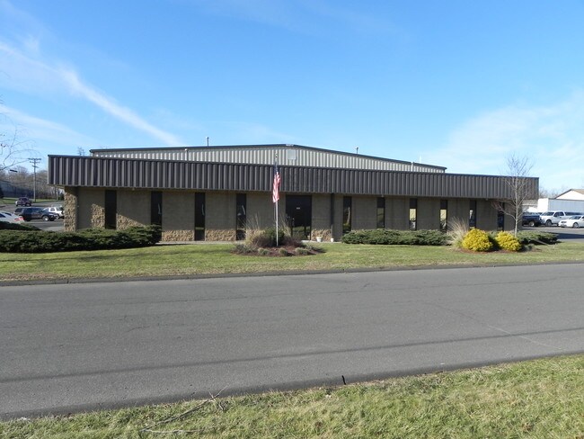

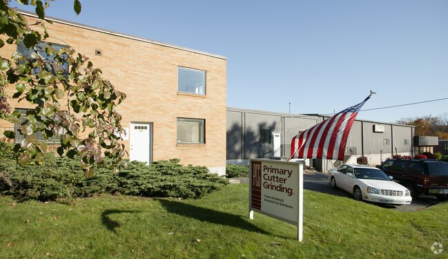
Property Detail
59 Deming Rd
BERL-000101-000081A-000008
Capitol
Manufacturinglight
Connecticut
GI-2
8
AE The base floodplain where base flood elevations are provided. AE Zones are now used on new format FIRMs instead of A1-A30 Zones.
2.09 AC
2025
Berlin
2025
Hartford
400101
Hartford-West Hartford-East Hartford, CT
29,728 SF
NEARBY LISTINGS FOR SALE OR LEASE
DEMOGRAPHICS near 59 Deming Rd
1 mile
3 mile
5 mile
2025 Total Population
2,581
61,108
153,213
2030 Population
2,642
61,600
154,852
Pop Growth 2025-2030
+ 2.36%
+ 0.81%
+ 1.07%
Average Age
44
41
41
2025 Total Households
1,113
24,659
61,965
HH Growth 2025-2030
+ 2.34%
+ 0.86%
+ 1.11%
Median Household Inc
$79,416
$73,670
$80,872
Avg Household Size
2.30
2.40
2.40
2025 Avg HH Vehicles
2.00
2.00
2.00
Median Home Value
$299,019
$318,996
$306,406
Median Year Built
1969
1962
1966
Nearby Places
Map Layers
Map Styles
 Street
 Aerial
Transit
 Traffic
 Biking
Places
Listings with unknown addresses are not visible on the map
- Restaurants
- Banks
- Shops
- Fitness
- Groceries
PUBLIC TRANSPORTATION
COMMUTER RAIL
Drive
Walk
Distance
4 min
1.6 mi
Drive
Walk
Distance
4 min
1.6 mi
AIRPORT
Bradley International
Drive
Walk
Distance
Bradley International
40 min
25.6 mi
Tweed/New Haven
Drive
Walk
Distance
Tweed/New Haven
46 min
30.6 mi
Freight Ports
Port of New Haven
Drive
Walk
Distance
Port of New Haven
40 min
29.4 mi
SALE & LEASE HISTORY
LISTING DATE
SALE/LEASE

Sep 25, 2016
For Lease
Nearby Properties
Address
Land Use
TOTAL SIZE
Lot Size
Zoning
Address
Land Use
TOTAL SIZE
Lot Size
Zoning
109,079 SF
110.62 AC
OT
Address
Land Use
TOTAL SIZE
Lot Size
Zoning
54.95 AC
PDR
Address
Land Use
TOTAL SIZE
Lot Size
Zoning
2.07 AC
CBD
Address
Land Use
TOTAL SIZE
Lot Size
Zoning
117,139 SF
6.77 AC
T
Address
Land Use
TOTAL SIZE
Lot Size
Zoning
90,625 SF
0.97 AC
CBD
Address
Land Use
TOTAL SIZE
Lot Size
Zoning
241,225 SF
25.64 AC
R-11
Address
Land Use
TOTAL SIZE
Lot Size
Zoning
96,238 SF
6.75 AC
T
Address
Land Use
TOTAL SIZE
Lot Size
Zoning
2.46 AC
CBD
Address
Land Use
TOTAL SIZE
Lot Size
Zoning
13.34 AC
PD
Address
Land Use
TOTAL SIZE
Lot Size
Zoning
33.36 AC
T
Address
Land Use
TOTAL SIZE
Lot Size
Zoning
78,109 SF
8.22 AC
T
Address
Land Use
TOTAL SIZE
Lot Size
Zoning
21.35 AC
PD
Address
Land Use
TOTAL SIZE
Lot Size
Zoning
68 AC
R-20
Address
Land Use
TOTAL SIZE
Lot Size
Zoning
18.40 AC
PD
Address
Land Use
TOTAL SIZE
Lot Size
Zoning
74,670 SF
4.46 AC
S2
Address
Land Use
TOTAL SIZE
Lot Size
Zoning
5.20 AC
PD
Address
Land Use
TOTAL SIZE
Lot Size
Zoning
38,860 SF
38.47 AC
PS-B
Address
Land Use
TOTAL SIZE
Lot Size
Zoning
83,464 SF
13.96 AC
T
Address
Land Use
TOTAL SIZE
Lot Size
Zoning
185,902 SF
101.89 AC
GI-2
Address
Land Use
TOTAL SIZE
Lot Size
Zoning
16.29 AC
PD
Address
Land Use
TOTAL SIZE
Lot Size
Zoning
76,510 SF
10 AC
R-11
Address
Land Use
TOTAL SIZE
Lot Size
Zoning
18.53 AC
BTD
Address
Land Use
TOTAL SIZE
Lot Size
Zoning
91,663 SF
22.20 AC
R-21
Address
Land Use
TOTAL SIZE
Lot Size
Zoning
2 AC
OP
Address
Land Use
TOTAL SIZE
Lot Size
Zoning
12.53 AC
CBD
Address
Land Use
TOTAL SIZE
Lot Size
Zoning
10.76 AC
PD
Address
Land Use
TOTAL SIZE
Lot Size
Zoning
44,084 SF
1.36 AC
T
Address
Land Use
TOTAL SIZE
Lot Size
Zoning
5.03 AC
OP
Address
Land Use
TOTAL SIZE
Lot Size
Zoning
25.10 AC
R-15
Address
Land Use
TOTAL SIZE
Lot Size
Zoning
125,492 SF
12.39 AC
PD
The World's #1 Commercial Real Estate Marketplace
Connect with us
© 2026 CoStar Group
The information above has been obtained from sources believed reliable. While we do not doubt its accuracy we have not verified it and make no guarantee, warranty or representation about it. It is your responsibility to independently confirm its accuracy and completeness. Any projections, opinions, assumptions, or estimates used are for example only and do not represent the current or future performance of the property. The value of this transaction to you depends on tax and other factors which should be evaluated by your tax, financial, and legal advisors. You and your advisors should conduct a careful, independent investigation of the property to determine to your satisfaction the suitability of the property for your needs.