Property Record
59 Hayes St, Newark, NJ 07103
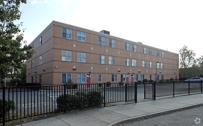

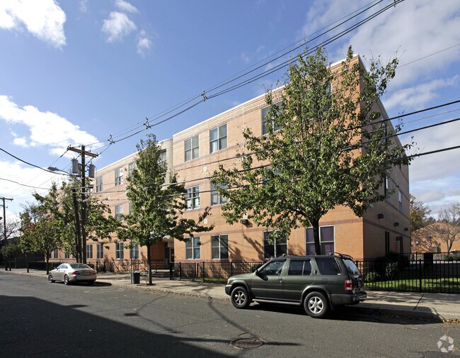

Property Detail
59 Hayes St
Newark, NJ
24.4X83.7 SCHOOLS
14-00249-0000-00014
Essex
Publicschool
New Jersey
B and X Area of moderate flood hazard, usually the area between the limits of the 100-year and 500-year floods.
14
0
0.05 AC
2026
Newark
008200
Northern New Jersey
1,339 SF
NEARBY LISTINGS FOR SALE OR LEASE
DEMOGRAPHICS near 59 Hayes St
1 mile
3 mile
5 mile
2025 Total Population
59,230
448,175
792,983
2030 Population
61,686
463,120
821,025
Pop Growth 2025-2030
+ 4.15%
+ 3.33%
+ 3.54%
Average Age
36
37
38
2025 Total Households
21,876
164,555
289,387
HH Growth 2025-2030
+ 4.84%
+ 3.74%
+ 3.85%
Median Household Inc
$38,790
$56,913
$68,315
Avg Household Size
2.40
2.60
2.60
2025 Avg HH Vehicles
1.00
1.00
1.00
Median Home Value
$290,557
$359,138
$428,876
Median Year Built
1984
1963
1958
Nearby Places
Map Layers
Map Styles
 Street
 Aerial
Layers
 Traffic
 Biking
Places
Listings with unknown addresses are not visible on the map
- Restaurants
- Banks
- Shops
- Fitness
- Groceries
PUBLIC TRANSPORTATION
TRANSIT/SUBWAY
Norfolk Street (Grove Street - Newark Penn Station - Newark Light Rail (Newark Light Rail))
Drive
Walk
Distance
Norfolk Street (Grove Street - Newark Penn Station - Newark Light Rail (Newark Light Rail))
2 min
15 min
0.8 mi
Warren Street (Grove Street - Newark Penn Station - Newark Light Rail (Newark Light Rail))
Drive
Walk
Distance
Warren Street (Grove Street - Newark Penn Station - Newark Light Rail (Newark Light Rail))
2 min
15 min
0.8 mi
Washington Street (Grove Street - Newark Penn Station - Newark Light Rail (Newark Light Rail))
Drive
Walk
Distance
Washington Street (Grove Street - Newark Penn Station - Newark Light Rail (Newark Light Rail))
2 min
18 min
1.0 mi
COMMUTER RAIL
Newark Penn Station (Broad Street Station - Newark Penn Station - NJ Transit Commuter Rail (NJ Transit), Grove Street - Newark Penn Station - NJ Transit Commuter Rail (NJ Transit), Newark Penn Station-World Trade Center - NJ Transit Commuter Rail (NJ Transit), North Jersey Coast Line - NJ Transit Commuter Rail (NJ Transit), Northeast Corridor Line - NJ Transit Commuter Rail (NJ Transit), Raritan Valley Line - NJ Transit Commuter Rail (NJ Transit))
Drive
Walk
Distance
Newark Penn Station (Broad Street Station - Newark Penn Station - NJ Transit Commuter Rail (NJ Transit), Grove Street - Newark Penn Station - NJ Transit Commuter Rail (NJ Transit), Newark Penn Station-World Trade Center - NJ Transit Commuter Rail (NJ Transit), North Jersey Coast Line - NJ Transit Commuter Rail (NJ Transit), Northeast Corridor Line - NJ Transit Commuter Rail (NJ Transit), Raritan Valley Line - NJ Transit Commuter Rail (NJ Transit))
3 min
1.5 mi
Newark Broad Street (Montclair-Boonton Line - NJ Transit Commuter Rail (NJ Transit), Morris & Essex Gladstone Branch - NJ Transit Commuter Rail (NJ Transit), Morris & Essex Morristown Line - NJ Transit Commuter Rail (NJ Transit))
Drive
Walk
Distance
Newark Broad Street (Montclair-Boonton Line - NJ Transit Commuter Rail (NJ Transit), Morris & Essex Gladstone Branch - NJ Transit Commuter Rail (NJ Transit), Morris & Essex Morristown Line - NJ Transit Commuter Rail (NJ Transit))
3 min
1.8 mi
AIRPORT
Newark Liberty International
Drive
Walk
Distance
Newark Liberty International
10 min
5.6 mi
LaGuardia
Drive
Walk
Distance
LaGuardia
43 min
28.2 mi
John F Kennedy International
Drive
Walk
Distance
John F Kennedy International
52 min
31.0 mi
Freight Ports
Port Newark Container Terminal
Drive
Walk
Distance
Port Newark Container Terminal
12 min
5.7 mi
Nearby Properties
Address
Land Use
TOTAL SIZE
Lot Size
Zoning
Address
Land Use
TOTAL SIZE
Lot Size
Zoning
0.57 AC
Address
Land Use
TOTAL SIZE
Lot Size
Zoning
57.23 AC
U
Address
Land Use
TOTAL SIZE
Lot Size
Zoning
0.45 AC
Address
Land Use
TOTAL SIZE
Lot Size
Zoning
Address
Land Use
TOTAL SIZE
Lot Size
Zoning
926,120 SF
11.46 AC
Address
Land Use
TOTAL SIZE
Lot Size
Zoning
0.61 AC
Address
Land Use
TOTAL SIZE
Lot Size
Zoning
31.86 AC
Address
Land Use
TOTAL SIZE
Lot Size
Zoning
Address
Land Use
TOTAL SIZE
Lot Size
Zoning
877 SF
7.25 AC
Address
Land Use
TOTAL SIZE
Lot Size
Zoning
1,136 SF
6.51 AC
Address
Land Use
TOTAL SIZE
Lot Size
Zoning
683 SF
9.59 AC
Address
Land Use
TOTAL SIZE
Lot Size
Zoning
2.01 AC
Address
Land Use
TOTAL SIZE
Lot Size
Zoning
3.42 AC
Address
Land Use
TOTAL SIZE
Lot Size
Zoning
320 SF
1.25 AC
Address
Land Use
TOTAL SIZE
Lot Size
Zoning
9.77 AC
Address
Land Use
TOTAL SIZE
Lot Size
Zoning
877 SF
0.91 AC
Address
Land Use
TOTAL SIZE
Lot Size
Zoning
1.64 AC
Address
Land Use
TOTAL SIZE
Lot Size
Zoning
Address
Land Use
TOTAL SIZE
Lot Size
Zoning
1.63 AC
Address
Land Use
TOTAL SIZE
Lot Size
Zoning
Address
Land Use
TOTAL SIZE
Lot Size
Zoning
2.79 AC
Address
Land Use
TOTAL SIZE
Lot Size
Zoning
4.82 AC
Address
Land Use
TOTAL SIZE
Lot Size
Zoning
0.13 AC
Address
Land Use
TOTAL SIZE
Lot Size
Zoning
1,264 SF
3.20 AC
Address
Land Use
TOTAL SIZE
Lot Size
Zoning
Address
Land Use
TOTAL SIZE
Lot Size
Zoning
0.06 AC
Address
Land Use
TOTAL SIZE
Lot Size
Zoning
0.09 AC
Address
Land Use
TOTAL SIZE
Lot Size
Zoning
877 SF
1.95 AC
Address
Land Use
TOTAL SIZE
Lot Size
Zoning
877 SF
1.35 AC
Address
Land Use
TOTAL SIZE
Lot Size
Zoning
16,084 SF
7.23 AC
The World's #1 Commercial Real Estate Marketplace
Connect with us
© 2026 CoStar Group
The information above has been obtained from sources believed reliable. While we do not doubt its accuracy we have not verified it and make no guarantee, warranty or representation about it. It is your responsibility to independently confirm its accuracy and completeness. Any projections, opinions, assumptions, or estimates used are for example only and do not represent the current or future performance of the property. The value of this transaction to you depends on tax and other factors which should be evaluated by your tax, financial, and legal advisors. You and your advisors should conduct a careful, independent investigation of the property to determine to your satisfaction the suitability of the property for your needs.