Property Record
59 Jackson St, Passaic, NJ 07055

Property Detail
59 Jackson St
New York-Jersey City-White Plains, NY-NJ
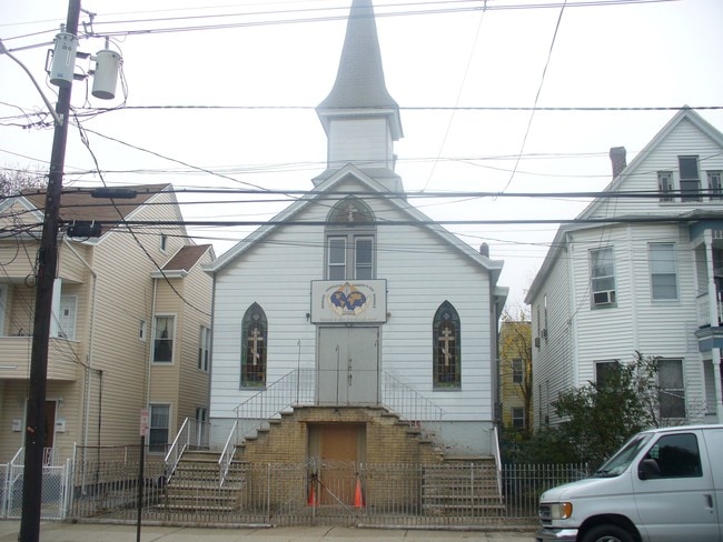
FACILITY NAME: CHURCH
07-04093-0000-00011
Passaic
Religious
New Jersey
R-3
11
B and X Area of moderate flood hazard, usually the area between the limits of the 100-year and 500-year floods.
0.09 AC
0
Route 3/GSP
2025
Northern New Jersey
175301
NEARBY LISTINGS FOR SALE OR LEASE
DEMOGRAPHICS near 59 Jackson St
1 mile
3 mile
5 mile
2025 Total Population
71,996
299,510
670,914
2030 Population
72,626
302,214
682,107
Pop Growth 2025-2030
+ 0.88%
+ 0.90%
+ 1.67%
Average Age
35
39
40
2025 Total Households
21,545
103,842
236,748
HH Growth 2025-2030
+ 0.71%
+ 0.90%
+ 1.79%
Median Household Inc
$53,520
$82,763
$87,794
Avg Household Size
3.20
2.80
2.70
2025 Avg HH Vehicles
1.00
2.00
2.00
Median Home Value
$414,623
$477,516
$479,402
Median Year Built
1947
1952
1954
Nearby Places
Map Layers
Map Styles
 Street
 Aerial
Transit
 Traffic
 Biking
Places
Listings with unknown addresses are not visible on the map
- Restaurants
- Banks
- Shops
- Fitness
- Groceries
PUBLIC TRANSPORTATION
COMMUTER RAIL
Garfield (Bergen County/Port Jervis Line - NJ Transit Commuter Rail (NJ Transit))
Drive
Walk
Distance
Garfield (Bergen County/Port Jervis Line - NJ Transit Commuter Rail (NJ Transit))
4 min
1.4 mi
Passaic (Main/Port Jervis Line - NJ Transit Commuter Rail (NJ Transit))
Drive
Walk
Distance
Passaic (Main/Port Jervis Line - NJ Transit Commuter Rail (NJ Transit))
4 min
1.6 mi
AIRPORT
Newark Liberty International
Drive
Walk
Distance
Newark Liberty International
21 min
16.3 mi
LaGuardia
Drive
Walk
Distance
LaGuardia
39 min
25.6 mi
John F Kennedy International
Drive
Walk
Distance
John F Kennedy International
51 min
30.8 mi
Freight Ports
Maher Terminal
Drive
Walk
Distance
Maher Terminal
27 min
16.5 mi
SALE & LEASE HISTORY
LISTING DATE
SALE/LEASE

Sep 23, 2016
For Sale
Mar 17, 2017
For Sale
Apr 04, 2017
For Sale
Nearby Properties
Address
Land Use
TOTAL SIZE
Lot Size
Zoning
Address
Land Use
TOTAL SIZE
Lot Size
Zoning
Address
Land Use
TOTAL SIZE
Lot Size
Zoning
4,014 SF
21 AC
Address
Land Use
TOTAL SIZE
Lot Size
Zoning
612 AC
SEA
Address
Land Use
TOTAL SIZE
Lot Size
Zoning
7.10 AC
R-3
Address
Land Use
TOTAL SIZE
Lot Size
Zoning
Address
Land Use
TOTAL SIZE
Lot Size
Zoning
8.66 AC
CH1
Address
Land Use
TOTAL SIZE
Lot Size
Zoning
1.12 AC
M-O
Address
Land Use
TOTAL SIZE
Lot Size
Zoning
7.29 AC
Address
Land Use
TOTAL SIZE
Lot Size
Zoning
Address
Land Use
TOTAL SIZE
Lot Size
Zoning
138,764 SF
1.47 AC
LM
Address
Land Use
TOTAL SIZE
Lot Size
Zoning
25.50 AC
B2
Address
Land Use
TOTAL SIZE
Lot Size
Zoning
26,816 SF
25.50 AC
POP
Address
Land Use
TOTAL SIZE
Lot Size
Zoning
Address
Land Use
TOTAL SIZE
Lot Size
Zoning
24.29 AC
Address
Land Use
TOTAL SIZE
Lot Size
Zoning
82.74 AC
Address
Land Use
TOTAL SIZE
Lot Size
Zoning
16.94 AC
R2
Address
Land Use
TOTAL SIZE
Lot Size
Zoning
24.35 AC
Address
Land Use
TOTAL SIZE
Lot Size
Zoning
13.80 AC
Address
Land Use
TOTAL SIZE
Lot Size
Zoning
152,050 SF
1.96 AC
B-1
Address
Land Use
TOTAL SIZE
Lot Size
Zoning
148,918 SF
4.17 AC
B
Address
Land Use
TOTAL SIZE
Lot Size
Zoning
13.36 AC
Address
Land Use
TOTAL SIZE
Lot Size
Zoning
5.40 AC
RB
Address
Land Use
TOTAL SIZE
Lot Size
Zoning
0.99 AC
Address
Land Use
TOTAL SIZE
Lot Size
Zoning
7.22 AC
M-3
Address
Land Use
TOTAL SIZE
Lot Size
Zoning
31.63 AC
I
Address
Land Use
TOTAL SIZE
Lot Size
Zoning
9.38 AC
B-A
Address
Land Use
TOTAL SIZE
Lot Size
Zoning
18.14 AC
R3
Address
Land Use
TOTAL SIZE
Lot Size
Zoning
4.09 AC
M-O
Address
Land Use
TOTAL SIZE
Lot Size
Zoning
6,712 SF
92 AC
C
Address
Land Use
TOTAL SIZE
Lot Size
Zoning
21.80 AC
R-A3
The World's #1 Commercial Real Estate Marketplace
Connect with us
© 2026 CoStar Group
The information above has been obtained from sources believed reliable. While we do not doubt its accuracy we have not verified it and make no guarantee, warranty or representation about it. It is your responsibility to independently confirm its accuracy and completeness. Any projections, opinions, assumptions, or estimates used are for example only and do not represent the current or future performance of the property. The value of this transaction to you depends on tax and other factors which should be evaluated by your tax, financial, and legal advisors. You and your advisors should conduct a careful, independent investigation of the property to determine to your satisfaction the suitability of the property for your needs.