Property Record
59 Walden St, Concord, MA 01742


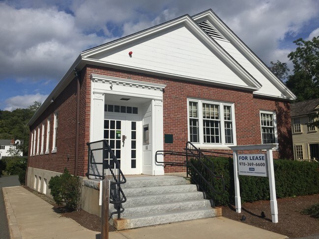
Property Detail
59 Walden St
Financialbuilding
Middlesex
LB2
Massachusetts
AE The base floodplain where base flood elevations are provided. AE Zones are now used on new format FIRMs instead of A1-A30 Zones.
0.44 AC
2025
Concord/Maynard
2025
Boston
361300
Boston-Cambridge-Newton, MA-NH
2,330 SF
CONC-000009H-000000-000115
NEARBY LISTINGS FOR SALE OR LEASE
DEMOGRAPHICS near 59 Walden St
1 mile
3 mile
5 mile
2025 Total Population
4,610
19,126
58,544
2030 Population
4,812
19,997
61,146
Pop Growth 2025-2030
+ 4.38%
+ 4.55%
+ 4.44%
Average Age
44
46
43
2025 Total Households
1,687
7,236
21,749
HH Growth 2025-2030
+ 4.51%
+ 4.81%
+ 4.59%
Median Household Inc
$204,176
$201,427
$186,352
Avg Household Size
2.60
2.50
2.60
2025 Avg HH Vehicles
2.00
2.00
2.00
Median Home Value
$1,107,409
$1,053,596
$1,004,579
Median Year Built
1957
1968
1972
Nearby Places
Map Layers
Map Styles
 Street
 Aerial
Layers
 Traffic
 Biking
Places
Listings with unknown addresses are not visible on the map
- Restaurants
- Banks
- Shops
- Fitness
- Groceries
PUBLIC TRANSPORTATION
COMMUTER RAIL
Concord (Fitchburg/South Acton Line - Massachusetts Bay Transportation Authority Commuter Rail (Purple Line))
Drive
Walk
Distance
Concord (Fitchburg/South Acton Line - Massachusetts Bay Transportation Authority Commuter Rail (Purple Line))
2 min
12 min
0.6 mi
West Concord (Fitchburg/South Acton Line - Massachusetts Bay Transportation Authority Commuter Rail (Purple Line))
Drive
Walk
Distance
West Concord (Fitchburg/South Acton Line - Massachusetts Bay Transportation Authority Commuter Rail (Purple Line))
5 min
2.6 mi
AIRPORT
General Edward Lawrence Logan International
Drive
Walk
Distance
General Edward Lawrence Logan International
36 min
23.5 mi
Worcester Regional
Drive
Walk
Distance
Worcester Regional
58 min
39.1 mi
Manchester Boston Regional
Drive
Walk
Distance
Manchester Boston Regional
63 min
43.0 mi
Freight Ports
Port of Boston
Drive
Walk
Distance
Port of Boston
35 min
21.9 mi
SALE & LEASE HISTORY
LISTING DATE
SALE/LEASE

Sep 25, 2016
For Lease
Oct 24, 2019
For Sale
Oct 01, 2018
For Lease
Nearby Properties
Address
Land Use
TOTAL SIZE
Lot Size
Zoning
Address
Land Use
TOTAL SIZE
Lot Size
Zoning
914,941 SF
30.97 AC
R1
Address
Land Use
TOTAL SIZE
Lot Size
Zoning
345,794 SF
24.17 AC
IND
Address
Land Use
TOTAL SIZE
Lot Size
Zoning
175,158 SF
54.36 AC
Address
Land Use
TOTAL SIZE
Lot Size
Zoning
417,293 SF
64.97 AC
I
Address
Land Use
TOTAL SIZE
Lot Size
Zoning
24,540 SF
24.99 AC
B
Address
Land Use
TOTAL SIZE
Lot Size
Zoning
93.60 AC
A
Address
Land Use
TOTAL SIZE
Lot Size
Zoning
130,529 SF
18.90 AC
A
Address
Land Use
TOTAL SIZE
Lot Size
Zoning
22,927 SF
51 AC
IPA
Address
Land Use
TOTAL SIZE
Lot Size
Zoning
18.78 AC
MP
Address
Land Use
TOTAL SIZE
Lot Size
Zoning
116,968 SF
3.44 AC
WCI
Address
Land Use
TOTAL SIZE
Lot Size
Zoning
77,323 SF
18 AC
C
Address
Land Use
TOTAL SIZE
Lot Size
Zoning
79,616 SF
27.03 AC
A
Address
Land Use
TOTAL SIZE
Lot Size
Zoning
51,488 SF
13.10 AC
Address
Land Use
TOTAL SIZE
Lot Size
Zoning
39,860 SF
20 AC
Address
Land Use
TOTAL SIZE
Lot Size
Zoning
125,387 SF
9.57 AC
B1
Address
Land Use
TOTAL SIZE
Lot Size
Zoning
31.29 AC
AA
Address
Land Use
TOTAL SIZE
Lot Size
Zoning
7.88 AC
B
Address
Land Use
TOTAL SIZE
Lot Size
Zoning
64,662 SF
3 AC
R1
Address
Land Use
TOTAL SIZE
Lot Size
Zoning
75,917 SF
28.56 AC
AA
Address
Land Use
TOTAL SIZE
Lot Size
Zoning
50,355 SF
6.38 AC
IPA
Address
Land Use
TOTAL SIZE
Lot Size
Zoning
83,954 SF
28.22 AC
IP
Address
Land Use
TOTAL SIZE
Lot Size
Zoning
38 AC
Address
Land Use
TOTAL SIZE
Lot Size
Zoning
53,684 SF
3 AC
C
Address
Land Use
TOTAL SIZE
Lot Size
Zoning
9.61 AC
I
Address
Land Use
TOTAL SIZE
Lot Size
Zoning
13.30 AC
AA
Address
Land Use
TOTAL SIZE
Lot Size
Zoning
63.75 AC
A
Address
Land Use
TOTAL SIZE
Lot Size
Zoning
37,309 SF
1.71 AC
B
Address
Land Use
TOTAL SIZE
Lot Size
Zoning
138.34 AC
A
Address
Land Use
TOTAL SIZE
Lot Size
Zoning
75,182 SF
6.74 AC
IPA
Address
Land Use
TOTAL SIZE
Lot Size
Zoning
170 AC
B
The World's #1 Commercial Real Estate Marketplace
Connect with us
© 2026 CoStar Group
The information above has been obtained from sources believed reliable. While we do not doubt its accuracy we have not verified it and make no guarantee, warranty or representation about it. It is your responsibility to independently confirm its accuracy and completeness. Any projections, opinions, assumptions, or estimates used are for example only and do not represent the current or future performance of the property. The value of this transaction to you depends on tax and other factors which should be evaluated by your tax, financial, and legal advisors. You and your advisors should conduct a careful, independent investigation of the property to determine to your satisfaction the suitability of the property for your needs.