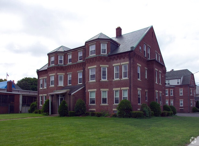
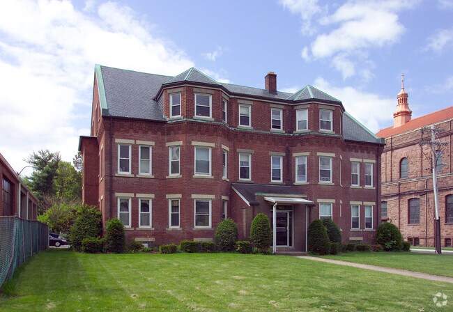
Property Record
590 Front St, Chicopee, MA 01013

Property Detail
590 Front St
Apartment
Hampden
102
Massachusetts
B and X Area of moderate flood hazard, usually the area between the limits of the 100-year and 500-year floods.
0.34 AC
2025
East Hampden County
2025
Hartford
810800
Springfield, MA
8,357 SF
CHIC-000081-000000-000015
NEARBY LISTINGS FOR SALE OR LEASE
-
-
View all Chicopee listings for sale on LoopNet.com
DEMOGRAPHICS near 590 Front St
1 mile
3 mile
5 mile
2025 Total Population
13,933
93,153
257,463
2030 Population
13,813
92,729
257,508
Pop Growth 2025-2030
(0.86%)
(0.46%)
+ 0.02%
Average Age
39
40
39
2025 Total Households
5,929
38,016
102,927
HH Growth 2025-2030
(0.93%)
(0.47%)
+ 0.04%
Median Household Inc
$60,745
$48,382
$53,456
Avg Household Size
2.20
2.30
2.40
2025 Avg HH Vehicles
1.00
1.00
1.00
Median Home Value
$276,635
$264,110
$267,807
Median Year Built
1947
1949
1954
Nearby Places
Map Layers
Map Styles
 Street
 Aerial
Transit
 Traffic
 Biking
Places
Listings with unknown addresses are not visible on the map
- Restaurants
- Banks
- Shops
- Fitness
- Groceries
PUBLIC TRANSPORTATION
COMMUTER RAIL
Drive
Walk
Distance
8 min
4.3 mi
Drive
Walk
Distance
9 min
5.0 mi
AIRPORT
Bradley International
Drive
Walk
Distance
Bradley International
35 min
17.0 mi
Nearby Properties
Address
Land Use
TOTAL SIZE
Lot Size
Zoning
Address
Land Use
TOTAL SIZE
Lot Size
Zoning
50.97 AC
BH
Address
Land Use
TOTAL SIZE
Lot Size
Zoning
263,462 SF
21.65 AC
R2
Address
Land Use
TOTAL SIZE
Lot Size
Zoning
209,471 SF
2.98 AC
SR3C1
Address
Land Use
TOTAL SIZE
Lot Size
Zoning
247,375 SF
19.52 AC
B2
Address
Land Use
TOTAL SIZE
Lot Size
Zoning
257,525 SF
64.03 AC
Address
Land Use
TOTAL SIZE
Lot Size
Zoning
48,924 SF
40.03 AC
I2
Address
Land Use
TOTAL SIZE
Lot Size
Zoning
21.80 AC
106
Address
Land Use
TOTAL SIZE
Lot Size
Zoning
141,970 SF
4.34 AC
S
Address
Land Use
TOTAL SIZE
Lot Size
Zoning
112,378 SF
3.03 AC
R2
Address
Land Use
TOTAL SIZE
Lot Size
Zoning
286,624 SF
17.40 AC
102
Address
Land Use
TOTAL SIZE
Lot Size
Zoning
261,176 SF
33.36 AC
Address
Land Use
TOTAL SIZE
Lot Size
Zoning
181,000 SF
34.48 AC
I1
Address
Land Use
TOTAL SIZE
Lot Size
Zoning
24.55 AC
102
Address
Land Use
TOTAL SIZE
Lot Size
Zoning
219,521 SF
7.50 AC
R2
Address
Land Use
TOTAL SIZE
Lot Size
Zoning
200,000 SF
13.91 AC
R3
Address
Land Use
TOTAL SIZE
Lot Size
Zoning
29.88 AC
105
Address
Land Use
TOTAL SIZE
Lot Size
Zoning
115,600 SF
4.25 AC
B2
Address
Land Use
TOTAL SIZE
Lot Size
Zoning
36.60 AC
SR2C1
Address
Land Use
TOTAL SIZE
Lot Size
Zoning
189,022 SF
10.62 AC
RA
Address
Land Use
TOTAL SIZE
Lot Size
Zoning
201,800 SF
6.27 AC
R5
Address
Land Use
TOTAL SIZE
Lot Size
Zoning
22.77 AC
111A
Address
Land Use
TOTAL SIZE
Lot Size
Zoning
186,700 SF
11.17 AC
SR3R5
Address
Land Use
TOTAL SIZE
Lot Size
Zoning
2,555 SF
166.42 AC
RB
Address
Land Use
TOTAL SIZE
Lot Size
Zoning
60,620 SF
4.96 AC
SR3B1
Address
Land Use
TOTAL SIZE
Lot Size
Zoning
217,116 SF
2.75 AC
R5
Address
Land Use
TOTAL SIZE
Lot Size
Zoning
77,012 SF
1.29 AC
B3
Address
Land Use
TOTAL SIZE
Lot Size
Zoning
102,787 SF
7.38 AC
I2
Address
Land Use
TOTAL SIZE
Lot Size
Zoning
29,464 SF
10.89 AC
R2
Address
Land Use
TOTAL SIZE
Lot Size
Zoning
138,504 SF
13.18 AC
RO
Address
Land Use
TOTAL SIZE
Lot Size
Zoning
171,241 SF
18.94 AC
106
The World's #1 Commercial Real Estate Marketplace
Connect with us
© 2026 CoStar Group
The information above has been obtained from sources believed reliable. While we do not doubt its accuracy we have not verified it and make no guarantee, warranty or representation about it. It is your responsibility to independently confirm its accuracy and completeness. Any projections, opinions, assumptions, or estimates used are for example only and do not represent the current or future performance of the property. The value of this transaction to you depends on tax and other factors which should be evaluated by your tax, financial, and legal advisors. You and your advisors should conduct a careful, independent investigation of the property to determine to your satisfaction the suitability of the property for your needs.