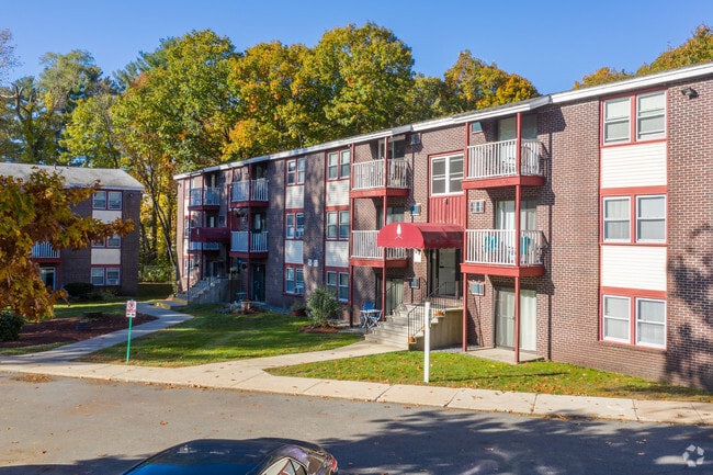
Property Record
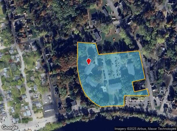
590 Merrimack Ave, Dracut, MA 01826
NEARBY LISTINGS FOR SALE OR LEASE
Property Detail
590 Merrimack Ave
DRAC-000072-000000-000014
Middlesex
Apartment
Massachusetts
AE
14
25009C0195G
6.70 AC
2025
Dracut
2025
Boston
314301
Boston-Cambridge-Newton, MA-NH
DEMOGRAPHICS near 590 Merrimack Ave
1 Mile
3 Mile
5 Mile
2024 Total Population
4,946
72,272
190,051
2029 Population
4,907
71,246
187,399
Pop Growth 2024-2029
(0.79%)
(1.42%)
(1.40%)
Average Age
43
39
39
2024 Total Households
1,824
27,182
68,480
HH Growth 2024-2029
(0.99%)
(1.44%)
(1.43%)
Median Household Inc
$120,951
$75,553
$83,391
Avg Household Size
2.70
2.50
2.60
2024 Avg HH Vehicles
2.00
2.00
2.00
Median Home Value
$493,187
$423,334
$425,433
Median Year Built
1977
1959
1964
Nearby Places
Map Layers
Map Styles
 Street
 Aerial
- Restaurants
- Banks
- Shops
- Fitness
- Groceries
PUBLIC TRANSPORTATION
COMMUTER RAIL
Lowell (Lowell Line - Massachusetts Bay Transportation Authority Commuter Rail (Purple Line))
DRIVE
WALK
Distance
Lowell (Lowell Line - Massachusetts Bay Transportation Authority Commuter Rail (Purple Line))
8 min
4.2 mi
North Billerica (Lowell Line - Massachusetts Bay Transportation Authority Commuter Rail (Purple Line))
DRIVE
WALK
Distance
North Billerica (Lowell Line - Massachusetts Bay Transportation Authority Commuter Rail (Purple Line))
15 min
7.3 mi
AIRPORT
Manchester Boston Regional
DRIVE
WALK
Distance
Manchester Boston Regional
45 min
29.7 mi
General Edward Lawrence Logan International
DRIVE
WALK
Distance
General Edward Lawrence Logan International
45 min
33.4 mi
Freight Ports
Port of Boston
DRIVE
WALK
Distance
Port of Boston
46 min
33.2 mi
Nearby Properties
Address
Land Use
TOTAL SIZE
Lot Size
Zoning
Address
Land Use
TOTAL SIZE
Lot Size
Zoning
52.80 AC
OR
Address
Land Use
TOTAL SIZE
Lot Size
Zoning
224,076 SF
1.15 AC
HCD
Address
Land Use
TOTAL SIZE
Lot Size
Zoning
803 SF
3.29 AC
R1
Address
Land Use
TOTAL SIZE
Lot Size
Zoning
215,884 SF
1.55 AC
DMU
Address
Land Use
TOTAL SIZE
Lot Size
Zoning
134,439 SF
3.29 AC
DMU
Address
Land Use
TOTAL SIZE
Lot Size
Zoning
6.30 AC
UMU
Address
Land Use
TOTAL SIZE
Lot Size
Zoning
67.55 AC
OR
Address
Land Use
TOTAL SIZE
Lot Size
Zoning
6.27 AC
DMU
Address
Land Use
TOTAL SIZE
Lot Size
Zoning
225,252 SF
2.31 AC
DMU
Address
Land Use
TOTAL SIZE
Lot Size
Zoning
152,040 SF
9.10 AC
SRC
Address
Land Use
TOTAL SIZE
Lot Size
Zoning
10.48 AC
INST
Address
Land Use
TOTAL SIZE
Lot Size
Zoning
7.25 AC
INST
Address
Land Use
TOTAL SIZE
Lot Size
Zoning
167,201 SF
6.31 AC
DMU
Address
Land Use
TOTAL SIZE
Lot Size
Zoning
20.88 AC
TSF
Address
Land Use
TOTAL SIZE
Lot Size
Zoning
185,172 SF
2.93 AC
DMU
Address
Land Use
TOTAL SIZE
Lot Size
Zoning
245,562 SF
1.44 AC
DMU
Address
Land Use
TOTAL SIZE
Lot Size
Zoning
13.74 AC
SSF
Address
Land Use
TOTAL SIZE
Lot Size
Zoning
95,745 SF
20.32 AC
TMF
Address
Land Use
TOTAL SIZE
Lot Size
Zoning
2.35 AC
DMU
Address
Land Use
TOTAL SIZE
Lot Size
Zoning
152,930 SF
3.44 AC
UMU
Address
Land Use
TOTAL SIZE
Lot Size
Zoning
122,533 SF
2.37 AC
DMU
Address
Land Use
TOTAL SIZE
Lot Size
Zoning
105,826 SF
2.27 AC
DMU
Address
Land Use
TOTAL SIZE
Lot Size
Zoning
101,618 SF
1.52 AC
UMU
Address
Land Use
TOTAL SIZE
Lot Size
Zoning
1.41 AC
UMU
Address
Land Use
TOTAL SIZE
Lot Size
Zoning
8,528 SF
4.59 AC
UMF
Address
Land Use
TOTAL SIZE
Lot Size
Zoning
187,442 SF
1.43 AC
DMU
Address
Land Use
TOTAL SIZE
Lot Size
Zoning
172,622 SF
22.32 AC
COM
Address
Land Use
TOTAL SIZE
Lot Size
Zoning
135,500 SF
17.96 AC
OR
Address
Land Use
TOTAL SIZE
Lot Size
Zoning
3.59 AC
UMF
Address
Land Use
TOTAL SIZE
Lot Size
Zoning
84,282 SF
23.15 AC
SSF
The World's #1 Commercial Real Estate Marketplace
Connect with us
© 2025 CoStar Group
The information above has been obtained from sources believed reliable. While we do not doubt its accuracy we have not verified it and make no guarantee, warranty or representation about it. It is your responsibility to independently confirm its accuracy and completeness. Any projections, opinions, assumptions, or estimates used are for example only and do not represent the current or future performance of the property. The value of this transaction to you depends on tax and other factors which should be evaluated by your tax, financial, and legal advisors. You and your advisors should conduct a careful, independent investigation of the property to determine to your satisfaction the suitability of the property for your needs.