Property Record
590 N 7Th St, Macclenny, FL 32063

NEARBY LISTINGS FOR SALE OR LEASE
-
-
View all Macclenny listings for sale on LoopNet.com
Property Detail
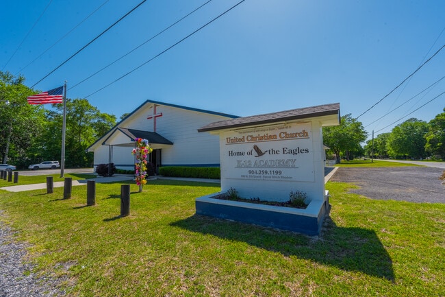
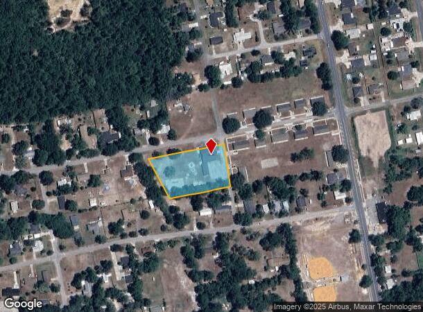
590 N 7Th St
Jacksonville, FL
E R Rhodens Add
29-2S-22-0028-0008-0010
LEG LOTS 1 2 & 3 BLK 8 E R RHODENS ADD PB 2 PG 4 DESC IN OR 2009-7852 POM 133A
Religious
Baker
X
Florida
12003C0217C
1
0
1.63 AC
2025
Baker County
040101
Jacksonville (Florida)
5,904 SF
DEMOGRAPHICS near 590 N 7Th St
1 Mile
3 Mile
5 Mile
2024 Total Population
6,925
16,357
20,130
2029 Population
8,418
19,891
24,340
Pop Growth 2024-2029
+ 21.56%
+ 21.61%
+ 20.91%
Average Age
38
39
39
2024 Total Households
2,427
5,775
7,082
HH Growth 2024-2029
+ 22.79%
+ 22.34%
+ 21.73%
Median Household Inc
$59,999
$69,062
$70,960
Avg Household Size
2.80
2.80
2.80
2024 Avg HH Vehicles
2.00
2.00
2.00
Median Home Value
$188,878
$195,809
$198,114
Median Year Built
1994
1993
1993
Nearby Places
Map Layers
Map Styles
 Street
 Aerial
- Restaurants
- Banks
- Shops
- Fitness
- Groceries
PUBLIC TRANSPORTATION
AIRPORT
Jacksonville International
DRIVE
WALK
Distance
Jacksonville International
54 min
40.3 mi
Freight Ports
Jacksonville Port
DRIVE
WALK
Distance
Jacksonville Port
46 min
34.1 mi
SALE & LEASE HISTORY
LISTING DATE
SALE/LEASE

Jun 05, 2025
For Sale
Nearby Properties
Address
Land Use
TOTAL SIZE
Lot Size
Zoning
Address
Land Use
TOTAL SIZE
Lot Size
Zoning
866,822 SF
123.04 AC
Address
Land Use
TOTAL SIZE
Lot Size
Zoning
100,000 SF
70.13 AC
Address
Land Use
TOTAL SIZE
Lot Size
Zoning
123,102 SF
70.72 AC
Address
Land Use
TOTAL SIZE
Lot Size
Zoning
100,000 SF
27.17 AC
Address
Land Use
TOTAL SIZE
Lot Size
Zoning
67,000 SF
20 AC
Address
Land Use
TOTAL SIZE
Lot Size
Zoning
160,877 SF
26.94 AC
Address
Land Use
TOTAL SIZE
Lot Size
Zoning
52,920 SF
9.51 AC
Address
Land Use
TOTAL SIZE
Lot Size
Zoning
65,821 SF
2.50 AC
Address
Land Use
TOTAL SIZE
Lot Size
Zoning
49,892 SF
2.58 AC
Address
Land Use
TOTAL SIZE
Lot Size
Zoning
70,998 SF
6.89 AC
Address
Land Use
TOTAL SIZE
Lot Size
Zoning
43,429 SF
6.85 AC
Address
Land Use
TOTAL SIZE
Lot Size
Zoning
6,200 SF
25.96 AC
Address
Land Use
TOTAL SIZE
Lot Size
Zoning
59,035 SF
3.90 AC
Address
Land Use
TOTAL SIZE
Lot Size
Zoning
33,512 SF
3.14 AC
Address
Land Use
TOTAL SIZE
Lot Size
Zoning
93,924 SF
26.81 AC
Address
Land Use
TOTAL SIZE
Lot Size
Zoning
29,512 SF
5.60 AC
Address
Land Use
TOTAL SIZE
Lot Size
Zoning
41,157 SF
7.60 AC
Address
Land Use
TOTAL SIZE
Lot Size
Zoning
38,674 SF
4.58 AC
Address
Land Use
TOTAL SIZE
Lot Size
Zoning
29,625 SF
12.63 AC
Address
Land Use
TOTAL SIZE
Lot Size
Zoning
23,400 SF
2.32 AC
Address
Land Use
TOTAL SIZE
Lot Size
Zoning
43,546 SF
16.62 AC
Address
Land Use
TOTAL SIZE
Lot Size
Zoning
3,360 SF
16.77 AC
Address
Land Use
TOTAL SIZE
Lot Size
Zoning
32,911 SF
3.60 AC
Address
Land Use
TOTAL SIZE
Lot Size
Zoning
13,387 SF
1.82 AC
Address
Land Use
TOTAL SIZE
Lot Size
Zoning
24,518 SF
3.01 AC
Address
Land Use
TOTAL SIZE
Lot Size
Zoning
13,094 SF
1.85 AC
Address
Land Use
TOTAL SIZE
Lot Size
Zoning
3,872 SF
131.02 AC
Address
Land Use
TOTAL SIZE
Lot Size
Zoning
18.86 AC
Address
Land Use
TOTAL SIZE
Lot Size
Zoning
10,000 SF
11 AC
Address
Land Use
TOTAL SIZE
Lot Size
Zoning
11,799 SF
1.44 AC
The World's #1 Commercial Real Estate Marketplace
Connect with us
© 2025 CoStar Group
The information above has been obtained from sources believed reliable. While we do not doubt its accuracy we have not verified it and make no guarantee, warranty or representation about it. It is your responsibility to independently confirm its accuracy and completeness. Any projections, opinions, assumptions, or estimates used are for example only and do not represent the current or future performance of the property. The value of this transaction to you depends on tax and other factors which should be evaluated by your tax, financial, and legal advisors. You and your advisors should conduct a careful, independent investigation of the property to determine to your satisfaction the suitability of the property for your needs.