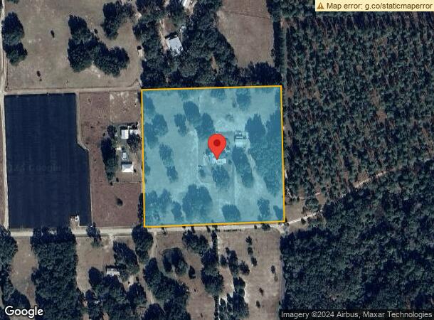
Property Record
3284 W State Road 40 Rd, Ormond Beach, FL 32174
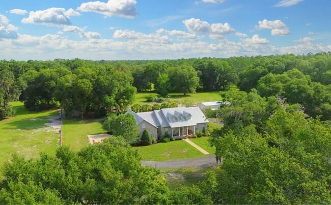

This Property Is For Sale
NEARBY LISTINGS FOR SALE OR LEASE
-
-
View all Ormond Beach listings for sale on LoopNet.com
Property Detail
3284 W State Road 40 Rd
3821-00-00-0070
Oak Ridge Meadows Subdivision
Dairyfarm
21-13-28 SE 1/4 OF NE 1/4 OF SE 1/4 PER OR 4863 PG 0729
X
Volusia
12127C0150J
Florida
2025
10.21 AC
2026
NW Volusia County
090101
Deltona/Daytona Beach
3,402 SF
Deltona-Daytona Beach-Ormond Beach, FL
DEMOGRAPHICS near 3284 W State Road 40 Rd
1 Mile
3 Mile
5 Mile
2024 Total Population
75
1,325
2,272
2029 Population
81
1,421
2,424
Pop Growth 2024-2029
+ 8.00%
+ 7.25%
+ 6.69%
Average Age
40
40
41
2024 Total Households
27
481
850
HH Growth 2024-2029
+ 7.41%
+ 7.48%
+ 6.82%
Median Household Inc
$74,999
$54,125
$47,009
Avg Household Size
2.50
2.70
2.60
2024 Avg HH Vehicles
3.00
2.00
2.00
Median Home Value
$405,556
$226,562
$281,481
Median Year Built
1977
1981
1983
Nearby Places
Map Layers
Map Styles
 Street
 Aerial
- Restaurants
- Banks
- Shops
- Fitness
- Groceries
PUBLIC TRANSPORTATION
AIRPORT
Daytona Beach International
DRIVE
WALK
Distance
Daytona Beach International
65 min
43.1 mi
Freight Ports
Jacksonville Port
DRIVE
WALK
Distance
Jacksonville Port
126 min
92.1 mi
Nearby Properties
Address
Land Use
TOTAL SIZE
Lot Size
Zoning
Address
Land Use
TOTAL SIZE
Lot Size
Zoning
85,860 SF
1 AC
RPUD
Address
Land Use
TOTAL SIZE
Lot Size
Zoning
8,951 SF
1.77 AC
Address
Land Use
TOTAL SIZE
Lot Size
Zoning
4,762 SF
3,576.52 AC
RC
Address
Land Use
TOTAL SIZE
Lot Size
Zoning
13,224 SF
7 AC
A3
Address
Land Use
TOTAL SIZE
Lot Size
Zoning
3,232 SF
33.96 AC
A3
Address
Land Use
TOTAL SIZE
Lot Size
Zoning
4,090 SF
15.75 AC
A1
Address
Land Use
TOTAL SIZE
Lot Size
Zoning
9,089 SF
0.69 AC
A3
Address
Land Use
TOTAL SIZE
Lot Size
Zoning
3,410 SF
10 AC
A1
Address
Land Use
TOTAL SIZE
Lot Size
Zoning
6,211 SF
10.01 AC
A1
Address
Land Use
TOTAL SIZE
Lot Size
Zoning
10,264 SF
35.42 AC
A1
Address
Land Use
TOTAL SIZE
Lot Size
Zoning
650.61 AC
RC
Address
Land Use
TOTAL SIZE
Lot Size
Zoning
500.34 AC
RC
Address
Land Use
TOTAL SIZE
Lot Size
Zoning
18,729 SF
3.53 AC
B4
Address
Land Use
TOTAL SIZE
Lot Size
Zoning
8,573 SF
2.06 AC
R4
Address
Land Use
TOTAL SIZE
Lot Size
Zoning
Address
Land Use
TOTAL SIZE
Lot Size
Zoning
920 SF
50.81 AC
A1
Address
Land Use
TOTAL SIZE
Lot Size
Zoning
2,367 SF
16.11 AC
A1
Address
Land Use
TOTAL SIZE
Lot Size
Zoning
2,280 SF
11.50 AC
A1
Address
Land Use
TOTAL SIZE
Lot Size
Zoning
2,464 SF
24.60 AC
Address
Land Use
TOTAL SIZE
Lot Size
Zoning
646.11 AC
RC
Address
Land Use
TOTAL SIZE
Lot Size
Zoning
2,083 SF
29.68 AC
RC
Address
Land Use
TOTAL SIZE
Lot Size
Zoning
2,472 SF
79.99 AC
A1
Address
Land Use
TOTAL SIZE
Lot Size
Zoning
2,090 SF
10.19 AC
A1
Address
Land Use
TOTAL SIZE
Lot Size
Zoning
3,093 SF
60 AC
RC
Address
Land Use
TOTAL SIZE
Lot Size
Zoning
3,033 SF
1.50 AC
B4
Address
Land Use
TOTAL SIZE
Lot Size
Zoning
1,640 SF
10.19 AC
A1
Address
Land Use
TOTAL SIZE
Lot Size
Zoning
2,130 SF
11.10 AC
A1
Address
Land Use
TOTAL SIZE
Lot Size
Zoning
2,852 SF
13.17 AC
A1
Address
Land Use
TOTAL SIZE
Lot Size
Zoning
759 SF
54 AC
A1
Address
Land Use
TOTAL SIZE
Lot Size
Zoning
14 AC
A1
The World's #1 Commercial Real Estate Marketplace
Connect with us
© 2026 CoStar Group
The information above has been obtained from sources believed reliable. While we do not doubt its accuracy we have not verified it and make no guarantee, warranty or representation about it. It is your responsibility to independently confirm its accuracy and completeness. Any projections, opinions, assumptions, or estimates used are for example only and do not represent the current or future performance of the property. The value of this transaction to you depends on tax and other factors which should be evaluated by your tax, financial, and legal advisors. You and your advisors should conduct a careful, independent investigation of the property to determine to your satisfaction the suitability of the property for your needs.