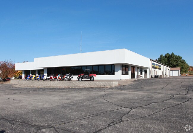
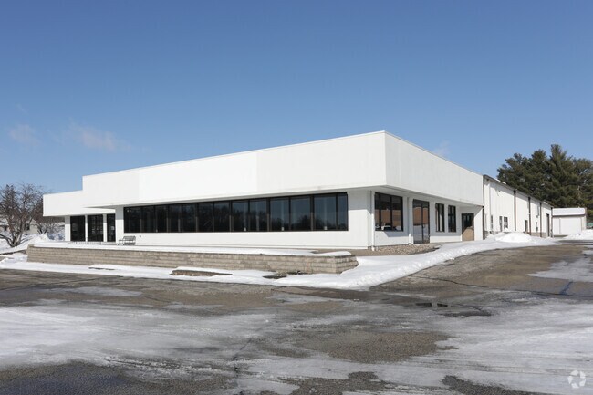
Property Record
590 S Wasson Ln, River Falls, WI 54022

NEARBY LISTINGS FOR SALE OR LEASE
Property Detail
590 S Wasson Ln
Minneapolis-St. Paul-Bloomington, MN-WI
LOT 1 CSM V 15 P 89 BEING PRT OF W1/2 OF SE1/4 (FORM PT OF CSM V 6 P 40) EX ROUND ABOUT R/W AS DESC IN TRANSPORTATION PLAT DO
276-01159-0100
Pierce
Municipalproperty
Wisconsin
X
1
55093C0126E
5.78 AC
0
Pierce County
2024
Minneapolis/St Paul
960300
DEMOGRAPHICS near 590 S Wasson Ln
1 Mile
3 Mile
5 Mile
2024 Total Population
8,541
20,149
22,799
2029 Population
8,902
21,278
24,124
Pop Growth 2024-2029
+ 4.23%
+ 5.60%
+ 5.81%
Average Age
33
36
37
2024 Total Households
2,659
7,445
8,423
HH Growth 2024-2029
+ 5.45%
+ 6.29%
+ 6.42%
Median Household Inc
$76,853
$73,843
$79,283
Avg Household Size
2.40
2.40
2.40
2024 Avg HH Vehicles
2.00
2.00
2.00
Median Home Value
$268,003
$270,734
$282,530
Median Year Built
1985
1989
1990
Nearby Places
Map Layers
Map Styles
 Street
 Aerial
- Restaurants
- Banks
- Shops
- Fitness
- Groceries
PUBLIC TRANSPORTATION
AIRPORT
Minneapolis-St Paul International/Wold-Chamberlain
DRIVE
WALK
Distance
Minneapolis-St Paul International/Wold-Chamberlain
51 min
39.3 mi
Freight Ports
Port Milwaukee
DRIVE
WALK
Distance
Port Milwaukee
344 min
309.6 mi
Nearby Properties
Address
Land Use
TOTAL SIZE
Lot Size
Zoning
Address
Land Use
TOTAL SIZE
Lot Size
Zoning
Address
Land Use
TOTAL SIZE
Lot Size
Zoning
1.28 AC
Address
Land Use
TOTAL SIZE
Lot Size
Zoning
5.98 AC
Address
Land Use
TOTAL SIZE
Lot Size
Zoning
8.11 AC
Address
Land Use
TOTAL SIZE
Lot Size
Zoning
1.55 AC
Address
Land Use
TOTAL SIZE
Lot Size
Zoning
Address
Land Use
TOTAL SIZE
Lot Size
Zoning
2.22 AC
Address
Land Use
TOTAL SIZE
Lot Size
Zoning
1.18 AC
Address
Land Use
TOTAL SIZE
Lot Size
Zoning
0.93 AC
Address
Land Use
TOTAL SIZE
Lot Size
Zoning
4.68 AC
Address
Land Use
TOTAL SIZE
Lot Size
Zoning
2.42 AC
Address
Land Use
TOTAL SIZE
Lot Size
Zoning
0.83 AC
Address
Land Use
TOTAL SIZE
Lot Size
Zoning
1.21 AC
Address
Land Use
TOTAL SIZE
Lot Size
Zoning
Address
Land Use
TOTAL SIZE
Lot Size
Zoning
5.09 AC
Address
Land Use
TOTAL SIZE
Lot Size
Zoning
Address
Land Use
TOTAL SIZE
Lot Size
Zoning
Address
Land Use
TOTAL SIZE
Lot Size
Zoning
Address
Land Use
TOTAL SIZE
Lot Size
Zoning
1.55 AC
Address
Land Use
TOTAL SIZE
Lot Size
Zoning
Address
Land Use
TOTAL SIZE
Lot Size
Zoning
Address
Land Use
TOTAL SIZE
Lot Size
Zoning
Address
Land Use
TOTAL SIZE
Lot Size
Zoning
1.14 AC
Address
Land Use
TOTAL SIZE
Lot Size
Zoning
2.79 AC
Address
Land Use
TOTAL SIZE
Lot Size
Zoning
5.63 AC
Address
Land Use
TOTAL SIZE
Lot Size
Zoning
Address
Land Use
TOTAL SIZE
Lot Size
Zoning
2.26 AC
Address
Land Use
TOTAL SIZE
Lot Size
Zoning
1.72 AC
Address
Land Use
TOTAL SIZE
Lot Size
Zoning
The World's #1 Commercial Real Estate Marketplace
Connect with us
© 2025 CoStar Group
The information above has been obtained from sources believed reliable. While we do not doubt its accuracy we have not verified it and make no guarantee, warranty or representation about it. It is your responsibility to independently confirm its accuracy and completeness. Any projections, opinions, assumptions, or estimates used are for example only and do not represent the current or future performance of the property. The value of this transaction to you depends on tax and other factors which should be evaluated by your tax, financial, and legal advisors. You and your advisors should conduct a careful, independent investigation of the property to determine to your satisfaction the suitability of the property for your needs.