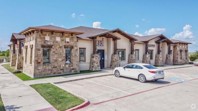
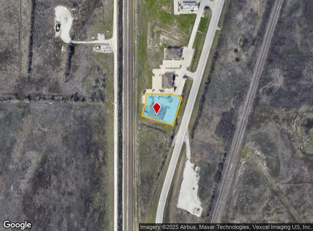
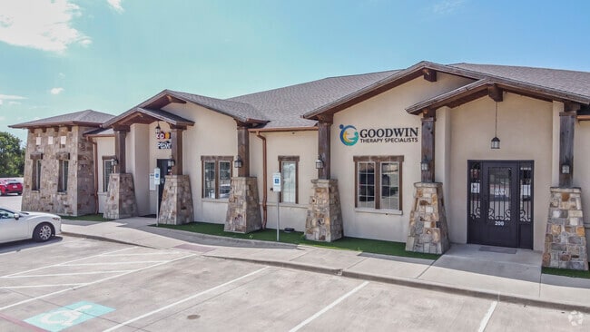
Property Record
590 State St S, Southlake, TX 76092
NEARBY LISTINGS FOR SALE OR LEASE
-
-
View all Southlake listings for lease on LoopNet.com
Property Detail
590 State St S
Dallas-Fort Worth-Arlington, TX
Letara Village
41600908
LETARA VILLAGE BLOCK 1 LOT 11
Commercialnec
Tarrant
X
Texas
48121C0660G
11
2024
0.85 AC
2025
Alliance
113956
Dallas/Ft Worth
6,504 SF
DEMOGRAPHICS near 590 State St S
1 Mile
3 Mile
5 Mile
2024 Total Population
1,056
25,840
106,573
2029 Population
1,150
28,379
114,295
Pop Growth 2024-2029
+ 8.90%
+ 9.83%
+ 7.25%
Average Age
39
34
34
2024 Total Households
372
8,028
34,306
HH Growth 2024-2029
+ 9.14%
+ 9.90%
+ 7.23%
Median Household Inc
$130,859
$132,288
$108,793
Avg Household Size
2.80
3.20
3.10
2024 Avg HH Vehicles
2.00
2.00
2.00
Median Home Value
$492,741
$347,832
$312,405
Median Year Built
2010
2010
2010
Nearby Places
Map Layers
Map Styles
 Street
 Aerial
- Restaurants
- Banks
- Shops
- Fitness
- Groceries
PUBLIC TRANSPORTATION
AIRPORT
Dallas-Fort Worth International
DRIVE
WALK
Distance
Dallas-Fort Worth International
33 min
24.3 mi
Dallas Love Field
DRIVE
WALK
Distance
Dallas Love Field
52 min
38.0 mi
SALE & LEASE HISTORY
LISTING DATE
SALE/LEASE

Sep 26, 2024
For Lease
Sep 25, 2016
For Lease
Mar 16, 2020
For Lease
Aug 23, 2024
For Lease
Apr 03, 2024
For Lease
Nearby Properties
Address
Land Use
TOTAL SIZE
Lot Size
Zoning
Address
Land Use
TOTAL SIZE
Lot Size
Zoning
348,270 SF
39.34 AC
Address
Land Use
TOTAL SIZE
Lot Size
Zoning
830,399 SF
11.02 AC
Address
Land Use
TOTAL SIZE
Lot Size
Zoning
553,605 SF
81.10 AC
Address
Land Use
TOTAL SIZE
Lot Size
Zoning
305,697 SF
42.24 AC
Address
Land Use
TOTAL SIZE
Lot Size
Zoning
1,150,000 SF
117.10 AC
Address
Land Use
TOTAL SIZE
Lot Size
Zoning
1,141,133 SF
67.79 AC
Address
Land Use
TOTAL SIZE
Lot Size
Zoning
1,179,900 SF
73.58 AC
Address
Land Use
TOTAL SIZE
Lot Size
Zoning
422,682 SF
22.66 AC
Address
Land Use
TOTAL SIZE
Lot Size
Zoning
504,000 SF
26.39 AC
Address
Land Use
TOTAL SIZE
Lot Size
Zoning
882,565 SF
56.65 AC
Address
Land Use
TOTAL SIZE
Lot Size
Zoning
1,001,600 SF
58.47 AC
Address
Land Use
TOTAL SIZE
Lot Size
Zoning
1,140,525 SF
45.79 AC
Address
Land Use
TOTAL SIZE
Lot Size
Zoning
807,229 SF
46.10 AC
Address
Land Use
TOTAL SIZE
Lot Size
Zoning
295,161 SF
257.32 AC
Address
Land Use
TOTAL SIZE
Lot Size
Zoning
727,900 SF
40.15 AC
Address
Land Use
TOTAL SIZE
Lot Size
Zoning
707,940 SF
35.33 AC
Address
Land Use
TOTAL SIZE
Lot Size
Zoning
677,700 SF
42.17 AC
Address
Land Use
TOTAL SIZE
Lot Size
Zoning
634,042 SF
35.88 AC
Address
Land Use
TOTAL SIZE
Lot Size
Zoning
562,500 SF
29.64 AC
Address
Land Use
TOTAL SIZE
Lot Size
Zoning
731,548 SF
56.18 AC
Address
Land Use
TOTAL SIZE
Lot Size
Zoning
184,400 SF
19.75 AC
Address
Land Use
TOTAL SIZE
Lot Size
Zoning
487,350 SF
26.34 AC
Address
Land Use
TOTAL SIZE
Lot Size
Zoning
436,589 SF
32.43 AC
Address
Land Use
TOTAL SIZE
Lot Size
Zoning
433,500 SF
27.58 AC
Address
Land Use
TOTAL SIZE
Lot Size
Zoning
360,000 SF
28.63 AC
Address
Land Use
TOTAL SIZE
Lot Size
Zoning
382,065 SF
22.24 AC
Address
Land Use
TOTAL SIZE
Lot Size
Zoning
422,373 SF
25.13 AC
Address
Land Use
TOTAL SIZE
Lot Size
Zoning
408,000 SF
20.66 AC
Address
Land Use
TOTAL SIZE
Lot Size
Zoning
436,589 SF
32.33 AC
Address
Land Use
TOTAL SIZE
Lot Size
Zoning
280,435 SF
16.29 AC
The World's #1 Commercial Real Estate Marketplace
Connect with us
© 2025 CoStar Group
The information above has been obtained from sources believed reliable. While we do not doubt its accuracy we have not verified it and make no guarantee, warranty or representation about it. It is your responsibility to independently confirm its accuracy and completeness. Any projections, opinions, assumptions, or estimates used are for example only and do not represent the current or future performance of the property. The value of this transaction to you depends on tax and other factors which should be evaluated by your tax, financial, and legal advisors. You and your advisors should conduct a careful, independent investigation of the property to determine to your satisfaction the suitability of the property for your needs.