Property Record
590 W Janet Ln, Pahrump, NV 89060
NEARBY LISTINGS FOR SALE OR LEASE
-
-
-
-
-
-
-
No Photo
-
View all Pahrump listings for sale on LoopNet.com
Property Detail
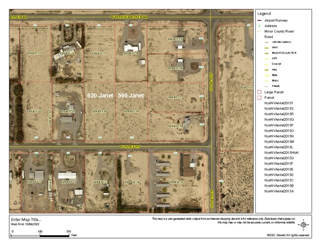
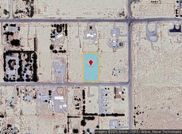
590 W Janet Ln
Pahrump, NV
Rancho Del Sol U.1
29-831-19
T19S R53E S33 U.1 B.1 L.19 RANCHO DEL SOL
Residentialacreage
Nye
X
Nevada
32023C8750F
19
2024
1.10 AC
2025
Carson City/Nevada Area
9604023020
Other Market Areas
DEMOGRAPHICS near 590 W Janet Ln
1 Mile
3 Mile
5 Mile
2024 Total Population
1,117
11,094
24,498
2029 Population
1,314
12,910
28,625
Pop Growth 2024-2029
+ 17.64%
+ 16.37%
+ 16.85%
Average Age
49
50
49
2024 Total Households
461
4,562
10,372
HH Growth 2024-2029
+ 17.57%
+ 16.68%
+ 17.07%
Median Household Inc
$66,331
$52,579
$51,540
Avg Household Size
2.30
2.30
2.30
2024 Avg HH Vehicles
2.00
2.00
2.00
Median Home Value
$177,611
$203,958
$219,904
Median Year Built
1994
1996
1996
Nearby Places
Map Layers
Map Styles
 Street
 Aerial
- Restaurants
- Banks
- Shops
- Fitness
- Groceries
SALE & LEASE HISTORY
LISTING DATE
SALE/LEASE

Jun 01, 2023
For Sale
Nearby Properties
Address
Land Use
TOTAL SIZE
Lot Size
Zoning
Address
Land Use
TOTAL SIZE
Lot Size
Zoning
191,653 SF
118.11 AC
CF
Address
Land Use
TOTAL SIZE
Lot Size
Zoning
128,429 SF
19.39 AC
CF
Address
Land Use
TOTAL SIZE
Lot Size
Zoning
51,128 SF
24.15 AC
M
Address
Land Use
TOTAL SIZE
Lot Size
Zoning
106,309 SF
12.24 AC
GC
Address
Land Use
TOTAL SIZE
Lot Size
Zoning
57,418 SF
18.28 AC
CF
Address
Land Use
TOTAL SIZE
Lot Size
Zoning
6.91 AC
LI
Address
Land Use
TOTAL SIZE
Lot Size
Zoning
48,436 SF
5 AC
M
Address
Land Use
TOTAL SIZE
Lot Size
Zoning
10,282 SF
34.27 AC
OS
Address
Land Use
TOTAL SIZE
Lot Size
Zoning
13,885 SF
2.01 AC
M
Address
Land Use
TOTAL SIZE
Lot Size
Zoning
12,160 SF
1.26 AC
M
Address
Land Use
TOTAL SIZE
Lot Size
Zoning
7,656 SF
5.75 AC
CF
Address
Land Use
TOTAL SIZE
Lot Size
Zoning
40,514 SF
142.77 AC
Address
Land Use
TOTAL SIZE
Lot Size
Zoning
8,400 SF
2.17 AC
GC
Address
Land Use
TOTAL SIZE
Lot Size
Zoning
9,306 SF
4.69 AC
MU
Address
Land Use
TOTAL SIZE
Lot Size
Zoning
0.46 AC
AO
Address
Land Use
TOTAL SIZE
Lot Size
Zoning
20,000 SF
4.60 AC
LI
Address
Land Use
TOTAL SIZE
Lot Size
Zoning
120.54 AC
GC
Address
Land Use
TOTAL SIZE
Lot Size
Zoning
10,932 SF
3.30 AC
GC
Address
Land Use
TOTAL SIZE
Lot Size
Zoning
4,984 SF
4.71 AC
HI
Address
Land Use
TOTAL SIZE
Lot Size
Zoning
8,548 SF
3.72 AC
MU
Address
Land Use
TOTAL SIZE
Lot Size
Zoning
8,320 SF
1.41 AC
NC
Address
Land Use
TOTAL SIZE
Lot Size
Zoning
9,230 SF
3.12 AC
GC
Address
Land Use
TOTAL SIZE
Lot Size
Zoning
10,310 SF
1.46 AC
CF
Address
Land Use
TOTAL SIZE
Lot Size
Zoning
75.38 AC
GC
Address
Land Use
TOTAL SIZE
Lot Size
Zoning
9,636 SF
1.80 AC
NC
Address
Land Use
TOTAL SIZE
Lot Size
Zoning
Address
Land Use
TOTAL SIZE
Lot Size
Zoning
0.54 AC
GC
Address
Land Use
TOTAL SIZE
Lot Size
Zoning
35,200 SF
3.23 AC
GC
Address
Land Use
TOTAL SIZE
Lot Size
Zoning
5,200 SF
0.51 AC
LI
Address
Land Use
TOTAL SIZE
Lot Size
Zoning
6,300 SF
2 AC
The World's #1 Commercial Real Estate Marketplace
Connect with us
© 2025 CoStar Group
The information above has been obtained from sources believed reliable. While we do not doubt its accuracy we have not verified it and make no guarantee, warranty or representation about it. It is your responsibility to independently confirm its accuracy and completeness. Any projections, opinions, assumptions, or estimates used are for example only and do not represent the current or future performance of the property. The value of this transaction to you depends on tax and other factors which should be evaluated by your tax, financial, and legal advisors. You and your advisors should conduct a careful, independent investigation of the property to determine to your satisfaction the suitability of the property for your needs.