Property Record
5900 211Th St, Matteson, IL 60443

This Property Is For Sale
Property Detail
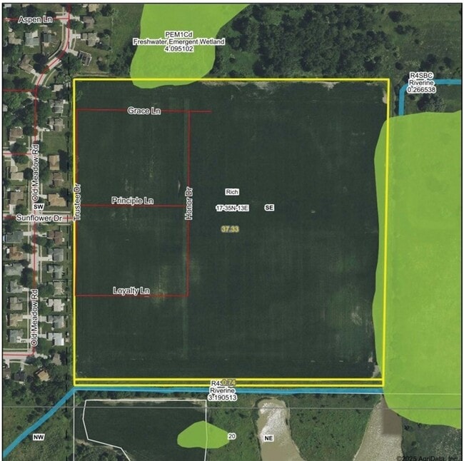
5900 211Th St
31-17-402-001-0000
COOK
Agriculturalland
Illinois
AE The base floodplain where base flood elevations are provided. AE Zones are now used on new format FIRMs instead of A1-A30 Zones.
40 AC
2023
Far South
2025
Chicago
830003
Chicago-Naperville-Elgin, IL-IN
NEARBY LISTINGS FOR SALE OR LEASE
DEMOGRAPHICS near 5900 211Th St
1 mile
3 mile
5 mile
2025 Total Population
7,465
45,577
136,585
2030 Population
7,695
46,356
138,872
Pop Growth 2025-2030
+ 3.08%
+ 1.71%
+ 1.67%
Average Age
44
42
42
2025 Total Households
2,704
16,513
51,154
HH Growth 2025-2030
+ 2.66%
+ 1.53%
+ 1.51%
Median Household Inc
$111,522
$98,179
$91,314
Avg Household Size
2.70
2.70
2.60
2025 Avg HH Vehicles
2.00
2.00
2.00
Median Home Value
$271,666
$264,257
$252,833
Median Year Built
2001
1985
1980
Nearby Places
Map Layers
Map Styles
 Street
 Aerial
Layers
 Traffic
 Biking
Places
Listings with unknown addresses are not visible on the map
- Restaurants
- Banks
- Shops
- Fitness
- Groceries
PUBLIC TRANSPORTATION
COMMUTER RAIL
Matteson Station (Metra Electric Line - Northeast Illinois Regional Commuter Railroad (Metra))
Drive
Walk
Distance
Matteson Station (Metra Electric Line - Northeast Illinois Regional Commuter Railroad (Metra))
11 min
5.2 mi
211Th Street (Lincoln Highway) Station (Metra Electric Line - Northeast Illinois Regional Commuter Railroad (Metra))
Drive
Walk
Distance
211Th Street (Lincoln Highway) Station (Metra Electric Line - Northeast Illinois Regional Commuter Railroad (Metra))
13 min
5.5 mi
AIRPORT
Chicago Midway International
Drive
Walk
Distance
Chicago Midway International
38 min
21.6 mi
Freight Ports
Port Milwaukee
Drive
Walk
Distance
Port Milwaukee
144 min
113.8 mi
Nearby Properties
Address
Land Use
TOTAL SIZE
Lot Size
Zoning
Address
Land Use
TOTAL SIZE
Lot Size
Zoning
3,480,853 SF
Address
Land Use
TOTAL SIZE
Lot Size
Zoning
Address
Land Use
TOTAL SIZE
Lot Size
Zoning
37.62 AC
Address
Land Use
TOTAL SIZE
Lot Size
Zoning
757,504 SF
46.30 AC
Address
Land Use
TOTAL SIZE
Lot Size
Zoning
Address
Land Use
TOTAL SIZE
Lot Size
Zoning
Address
Land Use
TOTAL SIZE
Lot Size
Zoning
194,292 SF
21.10 AC
Address
Land Use
TOTAL SIZE
Lot Size
Zoning
168,708 SF
14.74 AC
Address
Land Use
TOTAL SIZE
Lot Size
Zoning
911,379 SF
51.23 AC
Address
Land Use
TOTAL SIZE
Lot Size
Zoning
173,415 SF
14.97 AC
Address
Land Use
TOTAL SIZE
Lot Size
Zoning
300,399 SF
26.50 AC
Address
Land Use
TOTAL SIZE
Lot Size
Zoning
11.84 AC
Address
Land Use
TOTAL SIZE
Lot Size
Zoning
150,289 SF
16.40 AC
Address
Land Use
TOTAL SIZE
Lot Size
Zoning
192,369 SF
22.05 AC
Address
Land Use
TOTAL SIZE
Lot Size
Zoning
224,611 SF
0.90 AC
Address
Land Use
TOTAL SIZE
Lot Size
Zoning
322,629 SF
53.73 AC
Address
Land Use
TOTAL SIZE
Lot Size
Zoning
72,668 SF
3 AC
Address
Land Use
TOTAL SIZE
Lot Size
Zoning
2.94 AC
Address
Land Use
TOTAL SIZE
Lot Size
Zoning
4,168 SF
145.94 AC
Address
Land Use
TOTAL SIZE
Lot Size
Zoning
15.65 AC
Address
Land Use
TOTAL SIZE
Lot Size
Zoning
2.04 AC
Address
Land Use
TOTAL SIZE
Lot Size
Zoning
250,656 SF
Address
Land Use
TOTAL SIZE
Lot Size
Zoning
130,753 SF
8.12 AC
Address
Land Use
TOTAL SIZE
Lot Size
Zoning
3,011 SF
125.12 AC
Address
Land Use
TOTAL SIZE
Lot Size
Zoning
37,522 SF
2.78 AC
Address
Land Use
TOTAL SIZE
Lot Size
Zoning
133,342 SF
11.63 AC
Address
Land Use
TOTAL SIZE
Lot Size
Zoning
92,166 SF
23.83 AC
Address
Land Use
TOTAL SIZE
Lot Size
Zoning
96,255 SF
12.01 AC
Address
Land Use
TOTAL SIZE
Lot Size
Zoning
55,435 SF
6.43 AC
Address
Land Use
TOTAL SIZE
Lot Size
Zoning
114,992 SF
8.10 AC
The World's #1 Commercial Real Estate Marketplace
Connect with us
© 2026 CoStar Group
The information above has been obtained from sources believed reliable. While we do not doubt its accuracy we have not verified it and make no guarantee, warranty or representation about it. It is your responsibility to independently confirm its accuracy and completeness. Any projections, opinions, assumptions, or estimates used are for example only and do not represent the current or future performance of the property. The value of this transaction to you depends on tax and other factors which should be evaluated by your tax, financial, and legal advisors. You and your advisors should conduct a careful, independent investigation of the property to determine to your satisfaction the suitability of the property for your needs.