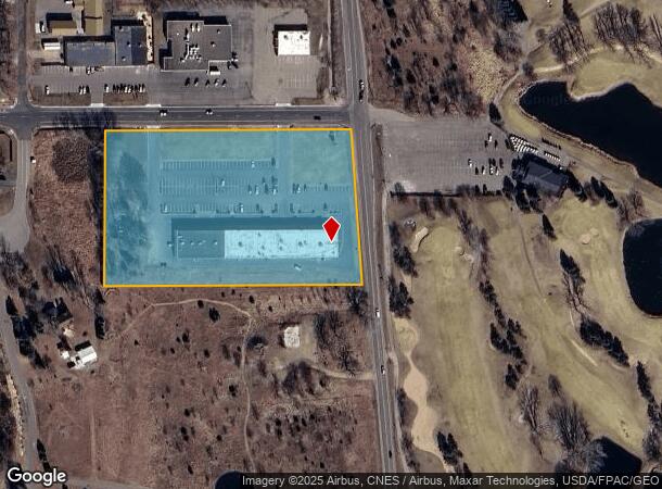
Property Record
5900 167Th Ave Nw, Anoka, MN 55303
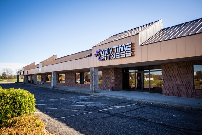
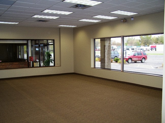
This Property Is For Sale
NEARBY LISTINGS FOR SALE OR LEASE
-
-
View all Anoka listings for sale on LoopNet.com
Property Detail
5900 167Th Ave Nw
11-32-25-43-0007
THE N 426.29 FT, AS MEAS ALG W LINE, OF THAT PRT OF SW1/4 OF SE1/4 OF SEC 11 TWP 32 RGE 25 LYG WLY OF C/L OF T H NO 47, EX RD, SUBJ TO EASE OF REC
Commercialnec
Anoka
X
Minnesota
27003C0170E
5.87 AC
2025
Coon Rapids
2025
Minneapolis/St Paul
050241
Minneapolis-St. Paul-Bloomington, MN-WI
29,440 SF
DEMOGRAPHICS near 5900 167Th Ave Nw
1 Mile
3 Mile
5 Mile
2024 Total Population
2,508
22,945
57,537
2029 Population
2,588
23,798
59,836
Pop Growth 2024-2029
+ 3.19%
+ 3.72%
+ 4.00%
Average Age
40
39
40
2024 Total Households
849
7,827
20,511
HH Growth 2024-2029
+ 3.18%
+ 3.77%
+ 4.07%
Median Household Inc
$139,898
$111,809
$103,365
Avg Household Size
2.90
2.90
2.70
2024 Avg HH Vehicles
3.00
2.00
2.00
Median Home Value
$369,652
$339,807
$335,477
Median Year Built
1988
1993
1990
Nearby Places
- Restaurants
- Banks
- Shops
- Fitness
- Groceries
PUBLIC TRANSPORTATION
COMMUTER RAIL
Ramsey Station & Platform (Northstar Commuter Rail - Metro Transit)
DRIVE
WALK
Distance
Ramsey Station & Platform (Northstar Commuter Rail - Metro Transit)
9 min
4.9 mi
Anoka Station (Northstar Corridor - Northstar Commuter Rail)
DRIVE
WALK
Distance
Anoka Station (Northstar Corridor - Northstar Commuter Rail)
10 min
5.5 mi
AIRPORT
Minneapolis-St Paul International/Wold-Chamberlain
DRIVE
WALK
Distance
Minneapolis-St Paul International/Wold-Chamberlain
54 min
37.8 mi
Freight Ports
Port Milwaukee
DRIVE
WALK
Distance
Port Milwaukee
399 min
360.0 mi
Nearby Properties
Address
Land Use
TOTAL SIZE
Lot Size
Zoning
Address
Land Use
TOTAL SIZE
Lot Size
Zoning
2,011 SF
34 AC
Address
Land Use
TOTAL SIZE
Lot Size
Zoning
75,262 SF
6.54 AC
Address
Land Use
TOTAL SIZE
Lot Size
Zoning
102,938 SF
Address
Land Use
TOTAL SIZE
Lot Size
Zoning
166,230 SF
36.66 AC
Address
Land Use
TOTAL SIZE
Lot Size
Zoning
125,349 SF
Address
Land Use
TOTAL SIZE
Lot Size
Zoning
122,762 SF
53.05 AC
Address
Land Use
TOTAL SIZE
Lot Size
Zoning
78,543 SF
4.47 AC
Address
Land Use
TOTAL SIZE
Lot Size
Zoning
1,880 SF
4.18 AC
Address
Land Use
TOTAL SIZE
Lot Size
Zoning
1,936 SF
35.53 AC
Address
Land Use
TOTAL SIZE
Lot Size
Zoning
41,472 SF
4.05 AC
Address
Land Use
TOTAL SIZE
Lot Size
Zoning
40,000 SF
2.81 AC
Address
Land Use
TOTAL SIZE
Lot Size
Zoning
41,560 SF
2.55 AC
Address
Land Use
TOTAL SIZE
Lot Size
Zoning
16,236 SF
1.74 AC
Address
Land Use
TOTAL SIZE
Lot Size
Zoning
33,624 SF
2.40 AC
Address
Land Use
TOTAL SIZE
Lot Size
Zoning
Address
Land Use
TOTAL SIZE
Lot Size
Zoning
30,240 SF
2.13 AC
Address
Land Use
TOTAL SIZE
Lot Size
Zoning
12,576 SF
3.14 AC
Address
Land Use
TOTAL SIZE
Lot Size
Zoning
3,520 SF
88.69 AC
Address
Land Use
TOTAL SIZE
Lot Size
Zoning
25,656 SF
1.85 AC
Address
Land Use
TOTAL SIZE
Lot Size
Zoning
110 AC
Address
Land Use
TOTAL SIZE
Lot Size
Zoning
17,254 SF
2.35 AC
Address
Land Use
TOTAL SIZE
Lot Size
Zoning
20,408 SF
1.87 AC
Address
Land Use
TOTAL SIZE
Lot Size
Zoning
2,897 SF
35.10 AC
Address
Land Use
TOTAL SIZE
Lot Size
Zoning
8,156 SF
3.36 AC
Address
Land Use
TOTAL SIZE
Lot Size
Zoning
14.46 AC
Address
Land Use
TOTAL SIZE
Lot Size
Zoning
11,525 SF
5.51 AC
Address
Land Use
TOTAL SIZE
Lot Size
Zoning
1,216 SF
40 AC
Address
Land Use
TOTAL SIZE
Lot Size
Zoning
21,436 SF
6.60 AC
Address
Land Use
TOTAL SIZE
Lot Size
Zoning
20,892 SF
5 AC
The World's #1 Commercial Real Estate Marketplace
Connect with us
© 2025 CoStar Group
The information above has been obtained from sources believed reliable. While we do not doubt its accuracy we have not verified it and make no guarantee, warranty or representation about it. It is your responsibility to independently confirm its accuracy and completeness. Any projections, opinions, assumptions, or estimates used are for example only and do not represent the current or future performance of the property. The value of this transaction to you depends on tax and other factors which should be evaluated by your tax, financial, and legal advisors. You and your advisors should conduct a careful, independent investigation of the property to determine to your satisfaction the suitability of the property for your needs.