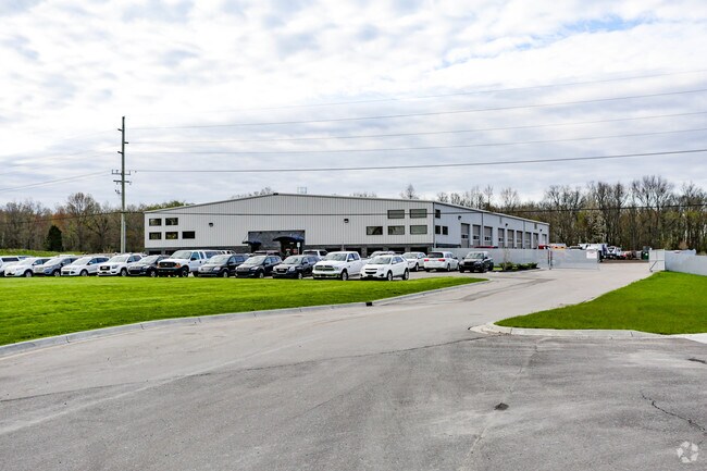
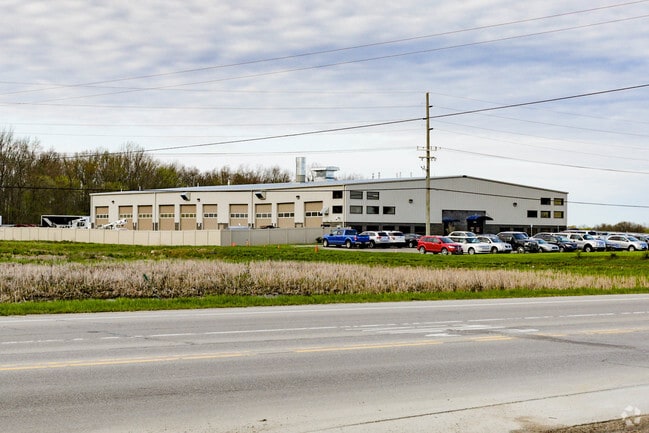
Property Record
5900 E Highland Rd, Howell, MI 48843

Property Detail
5900 E Highland Rd
07-27-200-030
SEC 27 T3N R5E BEG NE COR OF SEC TH ALG E LINE OF SD SEC & C.L. OF ARGENTINE RD S0*20'05"E 935.36 FT TH S89*59'54"W 250 FT TH
Commercialnec
Livingston
MI
Michigan
B and X Area of moderate flood hazard, usually the area between the limits of the 100-year and 500-year floods.
18.59 AC
2025
Livingston County
2025
Detroit
712602
Detroit-Warren-Dearborn, MI
24,000 SF
NEARBY LISTINGS FOR SALE OR LEASE
DEMOGRAPHICS near 5900 E Highland Rd
1 mile
3 mile
5 mile
2025 Total Population
555
11,003
41,577
2030 Population
555
11,168
42,139
Pop Growth 2025-2030
0.00%
+ 1.50%
+ 1.35%
Average Age
41
42
42
2025 Total Households
187
3,944
16,144
HH Growth 2025-2030
0.00%
+ 1.60%
+ 1.41%
Median Household Inc
$134,926
$130,597
$101,402
Avg Household Size
3.00
2.70
2.50
2025 Avg HH Vehicles
3.00
2.00
2.00
Median Home Value
$404,630
$390,498
$341,646
Median Year Built
1992
2000
1995
Nearby Places
Map Layers
Map Styles
 Street
 Aerial
Transit
 Traffic
 Biking
Places
Listings with unknown addresses are not visible on the map
- Restaurants
- Banks
- Shops
- Fitness
- Groceries
PUBLIC TRANSPORTATION
AIRPORT
Bishop International
Drive
Walk
Distance
Bishop International
47 min
30.3 mi
Freight Ports
Port of Toledo
Drive
Walk
Distance
Port of Toledo
111 min
89.8 mi
Nearby Properties
Address
Land Use
TOTAL SIZE
Lot Size
Zoning
Address
Land Use
TOTAL SIZE
Lot Size
Zoning
15.74 AC
RM
Address
Land Use
TOTAL SIZE
Lot Size
Zoning
87,349 SF
9.68 AC
C,RM,PUD
Address
Land Use
TOTAL SIZE
Lot Size
Zoning
57,582 SF
5.32 AC
C,RM,PUD
Address
Land Use
TOTAL SIZE
Lot Size
Zoning
92,475 SF
18.66 AC
MI
Address
Land Use
TOTAL SIZE
Lot Size
Zoning
12,870 SF
5.04 AC
C,RM,PUD
Address
Land Use
TOTAL SIZE
Lot Size
Zoning
3.86 AC
C,RM,PUD
Address
Land Use
TOTAL SIZE
Lot Size
Zoning
1,529 SF
42.07 AC
PRF
Address
Land Use
TOTAL SIZE
Lot Size
Zoning
59.56 AC
AR
Address
Land Use
TOTAL SIZE
Lot Size
Zoning
15.54 AC
C,RM,PUD
Address
Land Use
TOTAL SIZE
Lot Size
Zoning
13,008 SF
1.91 AC
C,RM,PUD
Address
Land Use
TOTAL SIZE
Lot Size
Zoning
1,216 SF
161.35 AC
AR
Address
Land Use
TOTAL SIZE
Lot Size
Zoning
1,440 SF
148.16 AC
AR
Address
Land Use
TOTAL SIZE
Lot Size
Zoning
20,000 SF
3.45 AC
MI
Address
Land Use
TOTAL SIZE
Lot Size
Zoning
3,438 SF
91.68 AC
CA
Address
Land Use
TOTAL SIZE
Lot Size
Zoning
10,589 SF
1.33 AC
C,RM,PUD
Address
Land Use
TOTAL SIZE
Lot Size
Zoning
2,784 SF
160.44 AC
AR
Address
Land Use
TOTAL SIZE
Lot Size
Zoning
4,176 SF
80 AC
CR1
Address
Land Use
TOTAL SIZE
Lot Size
Zoning
2,256 SF
150.50 AC
AR
Address
Land Use
TOTAL SIZE
Lot Size
Zoning
11.64 AC
C,RM,PUD
Address
Land Use
TOTAL SIZE
Lot Size
Zoning
29.84 AC
R2 & R3
Address
Land Use
TOTAL SIZE
Lot Size
Zoning
115.25 AC
AR
Address
Land Use
TOTAL SIZE
Lot Size
Zoning
13.37 AC
R2 & R3
Address
Land Use
TOTAL SIZE
Lot Size
Zoning
152 AC
AR
Address
Land Use
TOTAL SIZE
Lot Size
Zoning
7.88 AC
RM
Address
Land Use
TOTAL SIZE
Lot Size
Zoning
30.70 AC
R1
Address
Land Use
TOTAL SIZE
Lot Size
Zoning
83.06 AC
AR
Address
Land Use
TOTAL SIZE
Lot Size
Zoning
16.72 AC
R2 & R3
Address
Land Use
TOTAL SIZE
Lot Size
Zoning
26.86 AC
R2 & R3
Address
Land Use
TOTAL SIZE
Lot Size
Zoning
1,584 SF
79.04 AC
AR
The World's #1 Commercial Real Estate Marketplace
Connect with us
© 2026 CoStar Group
The information above has been obtained from sources believed reliable. While we do not doubt its accuracy we have not verified it and make no guarantee, warranty or representation about it. It is your responsibility to independently confirm its accuracy and completeness. Any projections, opinions, assumptions, or estimates used are for example only and do not represent the current or future performance of the property. The value of this transaction to you depends on tax and other factors which should be evaluated by your tax, financial, and legal advisors. You and your advisors should conduct a careful, independent investigation of the property to determine to your satisfaction the suitability of the property for your needs.