Property Record
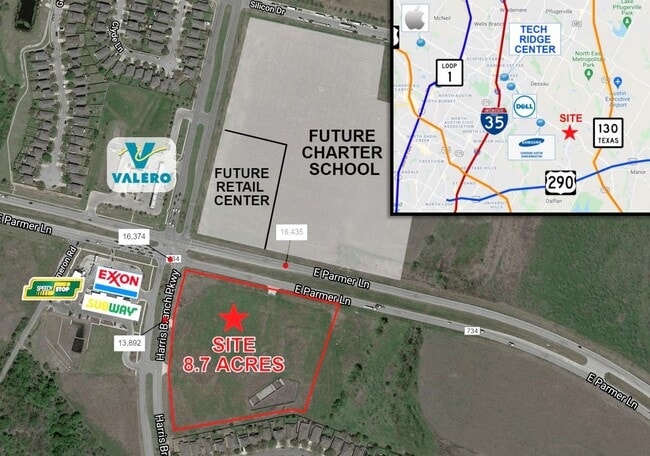
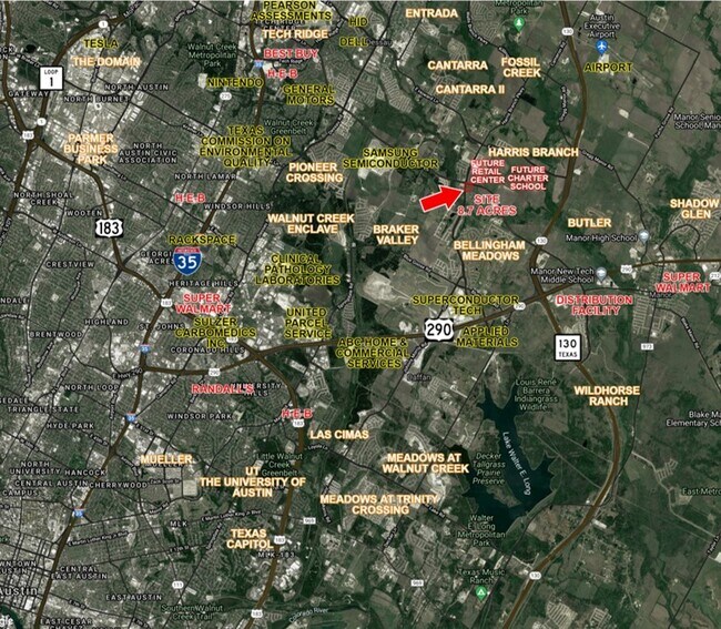
12209 Harris Branch Pkwy, Manor, TX 78653
Property Detail
12209 Harris Branch Pkwy
Austin-Round Rock-San Marcos, TX
LOT 4-B PARMER COMMONS SOUTHEAST CORNER
772876
TRAVIS
Vacantlandnec
Texas
B and X Area of moderate flood hazard, usually the area between the limits of the 100-year and 500-year floods.
4-b
2025
1.82 AC
2025
Far Northeast
002218
Austin
NEARBY LISTINGS FOR SALE OR LEASE
DEMOGRAPHICS near 12209 Harris Branch Pkwy
1 mile
3 mile
5 mile
2025 Total Population
5,907
35,978
146,339
2030 Population
6,206
38,404
154,837
Pop Growth 2025-2030
+ 5.06%
+ 6.74%
+ 5.81%
Average Age
36
36
36
2025 Total Households
2,042
12,622
51,816
HH Growth 2025-2030
+ 5.78%
+ 7.33%
+ 6.28%
Median Household Inc
$110,048
$93,473
$83,826
Avg Household Size
2.80
2.70
2.70
2025 Avg HH Vehicles
2.00
2.00
2.00
Median Home Value
$391,821
$371,375
$377,131
Median Year Built
2010
2010
2005
Nearby Places
Map Layers
Map Styles
 Street
 Aerial
Transit
 Traffic
 Biking
Places
Listings with unknown addresses are not visible on the map
- Restaurants
- Banks
- Shops
- Fitness
- Groceries
PUBLIC TRANSPORTATION
AIRPORT
Austin-Bergstrom International
Drive
Walk
Distance
Austin-Bergstrom International
29 min
20.1 mi
Freight Ports
Calhoun Port
Drive
Walk
Distance
Calhoun Port
189 min
163.0 mi
SALE & LEASE HISTORY
LISTING DATE
SALE/LEASE

Sep 24, 2016
For Sale
Mar 10, 2022
For Sale
Jun 29, 2022
For Lease
Nearby Properties
Address
Land Use
TOTAL SIZE
Lot Size
Zoning
Address
Land Use
TOTAL SIZE
Lot Size
Zoning
4,355 SF
263.17 AC
Address
Land Use
TOTAL SIZE
Lot Size
Zoning
729,000 SF
16.16 AC
Address
Land Use
TOTAL SIZE
Lot Size
Zoning
348,496 SF
17.59 AC
Address
Land Use
TOTAL SIZE
Lot Size
Zoning
398,475 SF
35.14 AC
Address
Land Use
TOTAL SIZE
Lot Size
Zoning
379,500 SF
17.99 AC
Address
Land Use
TOTAL SIZE
Lot Size
Zoning
381,495 SF
13.54 AC
Address
Land Use
TOTAL SIZE
Lot Size
Zoning
6,498 SF
236.84 AC
Address
Land Use
TOTAL SIZE
Lot Size
Zoning
459,304 SF
28.36 AC
Address
Land Use
TOTAL SIZE
Lot Size
Zoning
752,804 SF
180.91 AC
Address
Land Use
TOTAL SIZE
Lot Size
Zoning
411,429 SF
61.03 AC
Address
Land Use
TOTAL SIZE
Lot Size
Zoning
323,425 SF
14.20 AC
Address
Land Use
TOTAL SIZE
Lot Size
Zoning
384,776 SF
22.88 AC
Address
Land Use
TOTAL SIZE
Lot Size
Zoning
769,240 SF
71.87 AC
Address
Land Use
TOTAL SIZE
Lot Size
Zoning
297,000 SF
16.01 AC
Address
Land Use
TOTAL SIZE
Lot Size
Zoning
242,484 SF
15.50 AC
Address
Land Use
TOTAL SIZE
Lot Size
Zoning
400,630 SF
15.30 AC
Address
Land Use
TOTAL SIZE
Lot Size
Zoning
483,840 SF
47.88 AC
Address
Land Use
TOTAL SIZE
Lot Size
Zoning
266,728 SF
14.87 AC
Address
Land Use
TOTAL SIZE
Lot Size
Zoning
469,500 SF
24.44 AC
Address
Land Use
TOTAL SIZE
Lot Size
Zoning
261,594 SF
6.66 AC
Address
Land Use
TOTAL SIZE
Lot Size
Zoning
331,943 SF
22.87 AC
Address
Land Use
TOTAL SIZE
Lot Size
Zoning
326,138 SF
15.95 AC
Address
Land Use
TOTAL SIZE
Lot Size
Zoning
255,750 SF
13.38 AC
Address
Land Use
TOTAL SIZE
Lot Size
Zoning
594,000 SF
55.12 AC
Address
Land Use
TOTAL SIZE
Lot Size
Zoning
366,300 SF
29.88 AC
Address
Land Use
TOTAL SIZE
Lot Size
Zoning
194,700 SF
11.87 AC
Address
Land Use
TOTAL SIZE
Lot Size
Zoning
371,200 SF
27.11 AC
Address
Land Use
TOTAL SIZE
Lot Size
Zoning
297,000 SF
16.85 AC
Address
Land Use
TOTAL SIZE
Lot Size
Zoning
320.84 AC
Address
Land Use
TOTAL SIZE
Lot Size
Zoning
289,982 SF
21.01 AC
The World's #1 Commercial Real Estate Marketplace
Connect with us
© 2026 CoStar Group
The information above has been obtained from sources believed reliable. While we do not doubt its accuracy we have not verified it and make no guarantee, warranty or representation about it. It is your responsibility to independently confirm its accuracy and completeness. Any projections, opinions, assumptions, or estimates used are for example only and do not represent the current or future performance of the property. The value of this transaction to you depends on tax and other factors which should be evaluated by your tax, financial, and legal advisors. You and your advisors should conduct a careful, independent investigation of the property to determine to your satisfaction the suitability of the property for your needs.