Property Record
5900 State Road 43 St N, West Lafayette, IN 47906
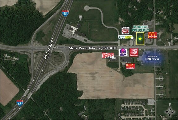

NEARBY LISTINGS FOR SALE OR LEASE
Property Detail
5900 State Road 43 St N
Lafayette-West Lafayette, IN
Northgate Sd
79-03-28-227-004.000-019
NORTHGATE SD PH 2 PT 2 LOT 2
Restaurantdrivein
Tippecanoe
X
Indiana
18181C0413D
2
2024
1.22 AC
2024
Lafayette/Kokomo
010201
Other Market Areas
2,256 SF
DEMOGRAPHICS near 5900 State Road 43 St N
1 Mile
3 Mile
5 Mile
2024 Total Population
2,265
11,905
45,566
2029 Population
2,354
12,416
46,896
Pop Growth 2024-2029
+ 3.93%
+ 4.29%
+ 2.92%
Average Age
38
40
37
2024 Total Households
813
4,294
18,332
HH Growth 2024-2029
+ 4.06%
+ 4.38%
+ 2.91%
Median Household Inc
$107,511
$97,812
$60,806
Avg Household Size
2.80
2.70
2.40
2024 Avg HH Vehicles
2.00
2.00
2.00
Median Home Value
$271,176
$290,675
$250,926
Median Year Built
2000
2002
1989
Nearby Places
Map Layers
Map Styles
 Street
 Aerial
- Restaurants
- Banks
- Shops
- Fitness
- Groceries
PUBLIC TRANSPORTATION
COMMUTER RAIL
Lafayette Amtrak Station (Cardinal - Amtrak)
DRIVE
WALK
Distance
Lafayette Amtrak Station (Cardinal - Amtrak)
12 min
7.7 mi
Freight Ports
Port Milwaukee
DRIVE
WALK
Distance
Port Milwaukee
240 min
201.1 mi
Nearby Properties
Address
Land Use
TOTAL SIZE
Lot Size
Zoning
Address
Land Use
TOTAL SIZE
Lot Size
Zoning
18,929 SF
33.83 AC
Address
Land Use
TOTAL SIZE
Lot Size
Zoning
0.01 AC
Address
Land Use
TOTAL SIZE
Lot Size
Zoning
63,256 SF
87 SF
Address
Land Use
TOTAL SIZE
Lot Size
Zoning
25,572 SF
87 SF
Address
Land Use
TOTAL SIZE
Lot Size
Zoning
14,264 SF
131 SF
Address
Land Use
TOTAL SIZE
Lot Size
Zoning
79,960 SF
44 SF
Address
Land Use
TOTAL SIZE
Lot Size
Zoning
15,340 SF
174 SF
Address
Land Use
TOTAL SIZE
Lot Size
Zoning
45,229 SF
4.86 AC
Address
Land Use
TOTAL SIZE
Lot Size
Zoning
4,600 SF
2.88 AC
Address
Land Use
TOTAL SIZE
Lot Size
Zoning
4,548 SF
1.25 AC
Address
Land Use
TOTAL SIZE
Lot Size
Zoning
8,560 SF
0.01 AC
Address
Land Use
TOTAL SIZE
Lot Size
Zoning
313.54 AC
Address
Land Use
TOTAL SIZE
Lot Size
Zoning
Address
Land Use
TOTAL SIZE
Lot Size
Zoning
18,011 SF
3.74 AC
Address
Land Use
TOTAL SIZE
Lot Size
Zoning
23,485 SF
15.72 AC
Address
Land Use
TOTAL SIZE
Lot Size
Zoning
34,240 SF
17.91 AC
Address
Land Use
TOTAL SIZE
Lot Size
Zoning
2,177 SF
1.02 AC
Address
Land Use
TOTAL SIZE
Lot Size
Zoning
26,196 SF
44 SF
Address
Land Use
TOTAL SIZE
Lot Size
Zoning
7,058 SF
3.84 AC
Address
Land Use
TOTAL SIZE
Lot Size
Zoning
Address
Land Use
TOTAL SIZE
Lot Size
Zoning
19,643 SF
44 SF
Address
Land Use
TOTAL SIZE
Lot Size
Zoning
9,192 SF
4.17 AC
Address
Land Use
TOTAL SIZE
Lot Size
Zoning
8,889 SF
87 SF
Address
Land Use
TOTAL SIZE
Lot Size
Zoning
9,624 SF
131 SF
Address
Land Use
TOTAL SIZE
Lot Size
Zoning
21.44 AC
Address
Land Use
TOTAL SIZE
Lot Size
Zoning
7,452 SF
0.96 AC
Address
Land Use
TOTAL SIZE
Lot Size
Zoning
83.51 AC
Address
Land Use
TOTAL SIZE
Lot Size
Zoning
Address
Land Use
TOTAL SIZE
Lot Size
Zoning
212,766 SF
44 SF
The World's #1 Commercial Real Estate Marketplace
Connect with us
© 2026 CoStar Group
The information above has been obtained from sources believed reliable. While we do not doubt its accuracy we have not verified it and make no guarantee, warranty or representation about it. It is your responsibility to independently confirm its accuracy and completeness. Any projections, opinions, assumptions, or estimates used are for example only and do not represent the current or future performance of the property. The value of this transaction to you depends on tax and other factors which should be evaluated by your tax, financial, and legal advisors. You and your advisors should conduct a careful, independent investigation of the property to determine to your satisfaction the suitability of the property for your needs.