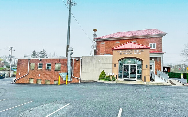
Property Record
5831 Linglestown Rd, Harrisburg, PA 17112
Property Detail
5831 Linglestown Rd
35-016-024
DAUPHIN
Policefirecivildefense
Pennsylvania
B and X Area of moderate flood hazard, usually the area between the limits of the 100-year and 500-year floods.
1.03 AC
2026
Harrisburg Area East
2026
Philadelphia
022502
Harrisburg-Carlisle, PA
7,840 SF
NEARBY LISTINGS FOR SALE OR LEASE
-
-
View all Harrisburg listings for sale on LoopNet.com
DEMOGRAPHICS near 5831 Linglestown Rd
1 mile
3 mile
5 mile
2025 Total Population
5,349
34,189
93,259
2030 Population
5,385
34,879
95,077
Pop Growth 2025-2030
+ 0.67%
+ 2.02%
+ 1.95%
Average Age
43
43
42
2025 Total Households
2,109
13,663
38,322
HH Growth 2025-2030
+ 0.71%
+ 2.12%
+ 2.06%
Median Household Inc
$99,440
$105,376
$92,838
Avg Household Size
2.50
2.40
2.40
2025 Avg HH Vehicles
2.00
2.00
2.00
Median Home Value
$268,105
$298,670
$278,591
Median Year Built
1975
1984
1980
Nearby Places
Map Layers
Map Styles
 Street
 Aerial
Layers
 Traffic
 Biking
Places
Listings with unknown addresses are not visible on the map
- Restaurants
- Banks
- Shops
- Fitness
- Groceries
PUBLIC TRANSPORTATION
AIRPORT
Harrisburg International
Drive
Walk
Distance
Harrisburg International
23 min
15.3 mi
Freight Ports
Port of Baltimore
Drive
Walk
Distance
Port of Baltimore
124 min
90.4 mi
SALE & LEASE HISTORY
LISTING DATE
SALE/LEASE

Apr 25, 2025
For Sale
Nearby Properties
Address
Land Use
TOTAL SIZE
Lot Size
Zoning
Address
Land Use
TOTAL SIZE
Lot Size
Zoning
2,856 SF
103 AC
Address
Land Use
TOTAL SIZE
Lot Size
Zoning
130,542 SF
28.94 AC
Address
Land Use
TOTAL SIZE
Lot Size
Zoning
2,823 SF
36.87 AC
Address
Land Use
TOTAL SIZE
Lot Size
Zoning
31,240 SF
20.25 AC
Address
Land Use
TOTAL SIZE
Lot Size
Zoning
82,881 SF
16.90 AC
Address
Land Use
TOTAL SIZE
Lot Size
Zoning
11,928 SF
8.40 AC
Address
Land Use
TOTAL SIZE
Lot Size
Zoning
9.88 AC
Address
Land Use
TOTAL SIZE
Lot Size
Zoning
199,920 SF
16.67 AC
Address
Land Use
TOTAL SIZE
Lot Size
Zoning
1,920 SF
38.44 AC
Address
Land Use
TOTAL SIZE
Lot Size
Zoning
7,264 SF
13.84 AC
Address
Land Use
TOTAL SIZE
Lot Size
Zoning
64,329 SF
14.70 AC
Address
Land Use
TOTAL SIZE
Lot Size
Zoning
1,484 SF
13.93 AC
Address
Land Use
TOTAL SIZE
Lot Size
Zoning
78,519 SF
48.60 AC
Address
Land Use
TOTAL SIZE
Lot Size
Zoning
84,210 SF
14.90 AC
Address
Land Use
TOTAL SIZE
Lot Size
Zoning
371,502 SF
29.96 AC
Address
Land Use
TOTAL SIZE
Lot Size
Zoning
10,044 SF
12.94 AC
Address
Land Use
TOTAL SIZE
Lot Size
Zoning
42,030 SF
10.29 AC
Address
Land Use
TOTAL SIZE
Lot Size
Zoning
54,630 SF
9.02 AC
Address
Land Use
TOTAL SIZE
Lot Size
Zoning
Address
Land Use
TOTAL SIZE
Lot Size
Zoning
72,474 SF
18 AC
Address
Land Use
TOTAL SIZE
Lot Size
Zoning
109,600 SF
11.13 AC
Address
Land Use
TOTAL SIZE
Lot Size
Zoning
148,690 SF
16.03 AC
Address
Land Use
TOTAL SIZE
Lot Size
Zoning
89,040 SF
6.96 AC
Address
Land Use
TOTAL SIZE
Lot Size
Zoning
56,297 SF
5.70 AC
Address
Land Use
TOTAL SIZE
Lot Size
Zoning
26,552 SF
8.74 AC
Address
Land Use
TOTAL SIZE
Lot Size
Zoning
2,392 SF
29.57 AC
Address
Land Use
TOTAL SIZE
Lot Size
Zoning
98,619 SF
5.20 AC
Address
Land Use
TOTAL SIZE
Lot Size
Zoning
91,650 SF
9.34 AC
Address
Land Use
TOTAL SIZE
Lot Size
Zoning
48,874 SF
7.22 AC
Address
Land Use
TOTAL SIZE
Lot Size
Zoning
76,080 SF
16.45 AC
The World's #1 Commercial Real Estate Marketplace
Connect with us
© 2026 CoStar Group
The information above has been obtained from sources believed reliable. While we do not doubt its accuracy we have not verified it and make no guarantee, warranty or representation about it. It is your responsibility to independently confirm its accuracy and completeness. Any projections, opinions, assumptions, or estimates used are for example only and do not represent the current or future performance of the property. The value of this transaction to you depends on tax and other factors which should be evaluated by your tax, financial, and legal advisors. You and your advisors should conduct a careful, independent investigation of the property to determine to your satisfaction the suitability of the property for your needs.