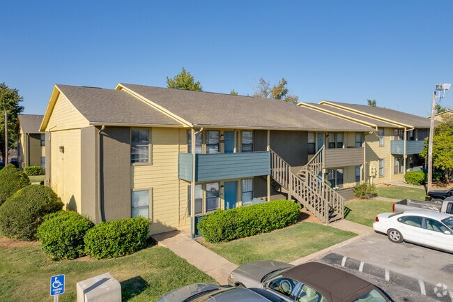
Property Record
5901 S May Ave, Oklahoma City, OK 73119


NEARBY LISTINGS FOR SALE OR LEASE
Property Detail
5901 S May Ave
132465501
Unpltd Pt Sec 24 11N 4W
Multifamilydwelling
UNPLTD PT SE4 SEC 24 11N 4W BEG 1050.09FT W & 50FT N OF SE/C SE4 TH W188.07FT N704.99FT SELY 201.79FT SELY 215.90FT E800.12FT S288.05FT W150FT S20FT W849.57FT S250FT TO BEG CONT 9.931 ACRS MORE OR LESS
X
Oklahoma
40027C0040J
Oklahoma
2023
9.93 AC
2024
Mayridge
107104
Oklahoma City
203,880 SF
Oklahoma City, OK
DEMOGRAPHICS near 5901 S May Ave
1 Mile
3 Mile
5 Mile
2024 Total Population
17,165
98,412
170,067
2029 Population
17,491
100,995
175,172
Pop Growth 2024-2029
+ 1.90%
+ 2.62%
+ 3.00%
Average Age
34
35
36
2024 Total Households
5,934
34,838
62,017
HH Growth 2024-2029
+ 2.06%
+ 2.70%
+ 3.13%
Median Household Inc
$41,392
$43,479
$46,405
Avg Household Size
2.70
2.70
2.60
2024 Avg HH Vehicles
2.00
2.00
2.00
Median Home Value
$77,965
$95,139
$124,077
Median Year Built
1963
1966
1971
Nearby Places
Map Layers
Map Styles
 Street
 Aerial
- Restaurants
- Banks
- Shops
- Fitness
- Groceries
PUBLIC TRANSPORTATION
COMMUTER RAIL
Oklahoma City (Heartland Flyer - Amtrak)
DRIVE
WALK
Distance
Oklahoma City (Heartland Flyer - Amtrak)
13 min
8.6 mi
AIRPORT
Will Rogers World
DRIVE
WALK
Distance
Will Rogers World
10 min
3.4 mi
Freight Ports
Tulsa Port Of Catoosa
DRIVE
WALK
Distance
Tulsa Port Of Catoosa
144 min
131.5 mi
SALE & LEASE HISTORY
LISTING DATE
SALE/LEASE

Nov 17, 2022
For Sale
Nearby Properties
Address
Land Use
TOTAL SIZE
Lot Size
Zoning
Address
Land Use
TOTAL SIZE
Lot Size
Zoning
192.48 AC
Address
Land Use
TOTAL SIZE
Lot Size
Zoning
64,658 SF
1.86 AC
SPUD
Address
Land Use
TOTAL SIZE
Lot Size
Zoning
Address
Land Use
TOTAL SIZE
Lot Size
Zoning
384,708 SF
17.05 AC
R-4
Address
Land Use
TOTAL SIZE
Lot Size
Zoning
27,056 SF
40.77 AC
Address
Land Use
TOTAL SIZE
Lot Size
Zoning
232,037 SF
18.80 AC
C-3
Address
Land Use
TOTAL SIZE
Lot Size
Zoning
239,760 SF
18.52 AC
PUD
Address
Land Use
TOTAL SIZE
Lot Size
Zoning
93,886 SF
8.57 AC
CO
Address
Land Use
TOTAL SIZE
Lot Size
Zoning
192,405 SF
24.38 AC
Address
Land Use
TOTAL SIZE
Lot Size
Zoning
259,726 SF
19.94 AC
PUD
Address
Land Use
TOTAL SIZE
Lot Size
Zoning
Address
Land Use
TOTAL SIZE
Lot Size
Zoning
192,771 SF
11.20 AC
I-3
Address
Land Use
TOTAL SIZE
Lot Size
Zoning
39,734 SF
5.16 AC
C-3
Address
Land Use
TOTAL SIZE
Lot Size
Zoning
10,110 SF
10 AC
Address
Land Use
TOTAL SIZE
Lot Size
Zoning
11,850 SF
1.49 AC
R-2
Address
Land Use
TOTAL SIZE
Lot Size
Zoning
158,150 SF
15.18 AC
I-2
Address
Land Use
TOTAL SIZE
Lot Size
Zoning
233,288 SF
24.24 AC
C-3
Address
Land Use
TOTAL SIZE
Lot Size
Zoning
18,999 SF
2.92 AC
Address
Land Use
TOTAL SIZE
Lot Size
Zoning
204,885 SF
24.62 AC
C-3
Address
Land Use
TOTAL SIZE
Lot Size
Zoning
7,496 SF
4.20 AC
Address
Land Use
TOTAL SIZE
Lot Size
Zoning
198,631 SF
13.26 AC
C-3
Address
Land Use
TOTAL SIZE
Lot Size
Zoning
66,705 SF
7.64 AC
RM
Address
Land Use
TOTAL SIZE
Lot Size
Zoning
204,532 SF
12.46 AC
R-4
Address
Land Use
TOTAL SIZE
Lot Size
Zoning
Address
Land Use
TOTAL SIZE
Lot Size
Zoning
235,670 SF
10.38 AC
R-4
Address
Land Use
TOTAL SIZE
Lot Size
Zoning
271,312 SF
13.06 AC
R-4
Address
Land Use
TOTAL SIZE
Lot Size
Zoning
92,222 SF
6.40 AC
R-4
Address
Land Use
TOTAL SIZE
Lot Size
Zoning
164,114 SF
21.70 AC
I-3
Address
Land Use
TOTAL SIZE
Lot Size
Zoning
149,745 SF
6.37 AC
R-4
The World's #1 Commercial Real Estate Marketplace
Connect with us
© 2025 CoStar Group
The information above has been obtained from sources believed reliable. While we do not doubt its accuracy we have not verified it and make no guarantee, warranty or representation about it. It is your responsibility to independently confirm its accuracy and completeness. Any projections, opinions, assumptions, or estimates used are for example only and do not represent the current or future performance of the property. The value of this transaction to you depends on tax and other factors which should be evaluated by your tax, financial, and legal advisors. You and your advisors should conduct a careful, independent investigation of the property to determine to your satisfaction the suitability of the property for your needs.