Property Record
5901 Weckerly Rd, Whitehouse, OH 43571
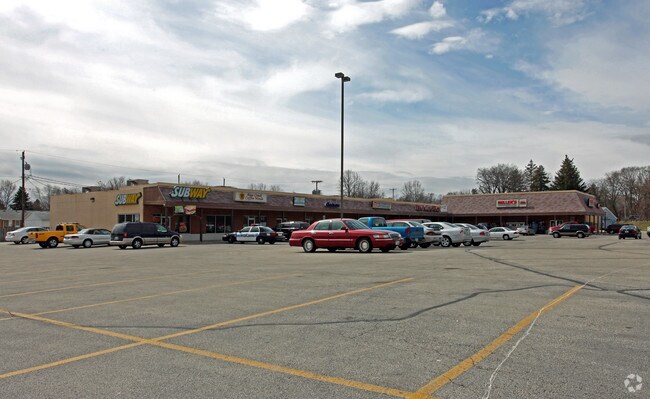

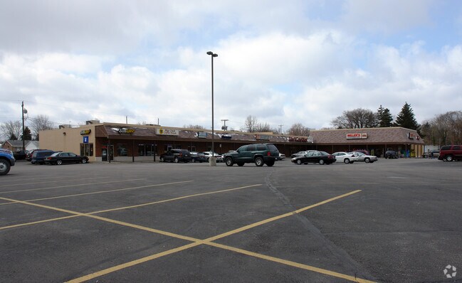
Property Detail
5901 Weckerly Rd
98-40027
9 7 25 SW 1/4 THT PT W1/2 SLY OF FINZELRD AS NOW LOCATED &
Regionalshoppingcenterormallwithanchorstore
LUCAS
23-C4
Ohio
B and X Area of moderate flood hazard, usually the area between the limits of the 100-year and 500-year floods.
4.13 AC
0
South/Southwest
2025
Toledo
008903
Toledo, OH
33,054 SF
NEARBY LISTINGS FOR SALE OR LEASE
-
-
View all Whitehouse listings for sale on LoopNet.com
DEMOGRAPHICS near 5901 Weckerly Rd
1 mile
3 mile
5 mile
2025 Total Population
2,243
11,388
30,998
2030 Population
2,222
11,324
30,796
Pop Growth 2025-2030
(0.94%)
(0.56%)
(0.65%)
Average Age
41
41
43
2025 Total Households
845
4,215
11,709
HH Growth 2025-2030
(1.07%)
(0.62%)
(0.71%)
Median Household Inc
$113,684
$118,234
$119,511
Avg Household Size
2.60
2.70
2.60
2025 Avg HH Vehicles
2.00
2.00
2.00
Median Home Value
$367,412
$351,234
$345,228
Median Year Built
1995
1994
1997
Nearby Places
Map Layers
Map Styles
 Street
 Aerial
Transit
 Traffic
 Biking
Places
Listings with unknown addresses are not visible on the map
- Restaurants
- Banks
- Shops
- Fitness
- Groceries
PUBLIC TRANSPORTATION
AIRPORT
Eugene F Kranz Toledo Express
Drive
Walk
Distance
Eugene F Kranz Toledo Express
16 min
6.5 mi
Freight Ports
Port of Toledo
Drive
Walk
Distance
Port of Toledo
39 min
24.0 mi
Nearby Properties
Address
Land Use
TOTAL SIZE
Lot Size
Zoning
Address
Land Use
TOTAL SIZE
Lot Size
Zoning
110,484 SF
8.35 AC
NOTZONED
Address
Land Use
TOTAL SIZE
Lot Size
Zoning
193,333 SF
14.84 AC
NOTZONED
Address
Land Use
TOTAL SIZE
Lot Size
Zoning
186,336 SF
14.06 AC
NOTZONED
Address
Land Use
TOTAL SIZE
Lot Size
Zoning
227,690 SF
36.62 AC
23-S1
Address
Land Use
TOTAL SIZE
Lot Size
Zoning
15.26 AC
NOTZONED
Address
Land Use
TOTAL SIZE
Lot Size
Zoning
65,133 SF
13.98 AC
23-R3
Address
Land Use
TOTAL SIZE
Lot Size
Zoning
108,253 SF
83.59 AC
22-A
Address
Land Use
TOTAL SIZE
Lot Size
Zoning
87,021 SF
20 AC
23-S1
Address
Land Use
TOTAL SIZE
Lot Size
Zoning
76,002 SF
3.48 AC
NOTZONED
Address
Land Use
TOTAL SIZE
Lot Size
Zoning
73,656 SF
3.33 AC
NOTZONED
Address
Land Use
TOTAL SIZE
Lot Size
Zoning
289,049 SF
43.63 AC
23-MX
Address
Land Use
TOTAL SIZE
Lot Size
Zoning
106,703 SF
7 AC
22-RA
Address
Land Use
TOTAL SIZE
Lot Size
Zoning
72,061 SF
21.21 AC
23-S1
Address
Land Use
TOTAL SIZE
Lot Size
Zoning
31,790 SF
9.21 AC
NOTZONED
Address
Land Use
TOTAL SIZE
Lot Size
Zoning
76,272 SF
16.76 AC
23-M1
Address
Land Use
TOTAL SIZE
Lot Size
Zoning
9,381 SF
414.42 AC
33-A
Address
Land Use
TOTAL SIZE
Lot Size
Zoning
26,862 SF
2.67 AC
23-S1
Address
Land Use
TOTAL SIZE
Lot Size
Zoning
63,038 SF
4.74 AC
17-RA
Address
Land Use
TOTAL SIZE
Lot Size
Zoning
Address
Land Use
TOTAL SIZE
Lot Size
Zoning
3 AC
NOTZONED
Address
Land Use
TOTAL SIZE
Lot Size
Zoning
73,933 SF
8.94 AC
Address
Land Use
TOTAL SIZE
Lot Size
Zoning
35,868 SF
2.84 AC
NOTZONED
Address
Land Use
TOTAL SIZE
Lot Size
Zoning
17,180 SF
29.43 AC
39-P1
Address
Land Use
TOTAL SIZE
Lot Size
Zoning
72,286 SF
104.25 AC
22-A
Address
Land Use
TOTAL SIZE
Lot Size
Zoning
1 AC
NOTZONED
Address
Land Use
TOTAL SIZE
Lot Size
Zoning
28,747 SF
8.91 AC
23-R3
Address
Land Use
TOTAL SIZE
Lot Size
Zoning
28,032 SF
2.95 AC
23-R5
Address
Land Use
TOTAL SIZE
Lot Size
Zoning
20,000 SF
3.62 AC
23-C3
Address
Land Use
TOTAL SIZE
Lot Size
Zoning
14,195 SF
1.75 AC
23-C2
Address
Land Use
TOTAL SIZE
Lot Size
Zoning
4,000 SF
207.48 AC
22-A
The World's #1 Commercial Real Estate Marketplace
Connect with us
© 2026 CoStar Group
The information above has been obtained from sources believed reliable. While we do not doubt its accuracy we have not verified it and make no guarantee, warranty or representation about it. It is your responsibility to independently confirm its accuracy and completeness. Any projections, opinions, assumptions, or estimates used are for example only and do not represent the current or future performance of the property. The value of this transaction to you depends on tax and other factors which should be evaluated by your tax, financial, and legal advisors. You and your advisors should conduct a careful, independent investigation of the property to determine to your satisfaction the suitability of the property for your needs.