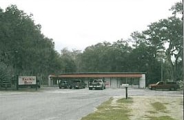
Property Record
5902 Se Hawthorne Rd, Gainesville, FL 32641


NEARBY LISTINGS FOR SALE OR LEASE
-
-
View all Gainesville listings for sale on LoopNet.com
Property Detail
5902 Se Hawthorne Rd
18001-001-000
Capstone Quarters
Departmentstore
COM SW COR SEC N 00 DEG 04 MIN 56 SEC W 1102.16 FT S 89 DEG 39 MIN 40 SEC E 20.75 FT POB NWLY ALG CURVE 109.49 FT N 89 DEG 19 MIN 45 SEC E 417.30 FT N 00 DEG 20 MIN 20 SEC E 108.94 FT N 89 DEG 19 MIN 45 SEC E 368.15 FT S 00 DEG 20 MIN 20 SEC W 231.76
A
Alachua
12001C0460D
Florida
2025
4.06 AC
2025
Gainesville
001400
Other Market Areas
8,560 SF
Gainesville, FL
DEMOGRAPHICS near 5902 Se Hawthorne Rd
1 Mile
3 Mile
5 Mile
2024 Total Population
106
6,594
30,422
2029 Population
112
6,968
32,303
Pop Growth 2024-2029
+ 5.66%
+ 5.67%
+ 6.18%
Average Age
40
40
37
2024 Total Households
43
2,146
11,765
HH Growth 2024-2029
+ 4.65%
+ 5.50%
+ 5.99%
Median Household Inc
$59,999
$45,781
$38,784
Avg Household Size
2.30
2.40
2.30
2024 Avg HH Vehicles
2.00
2.00
2.00
Median Home Value
$164,999
$136,713
$147,710
Median Year Built
1972
1972
1973
Nearby Places
Map Layers
Map Styles
 Street
 Aerial
- Restaurants
- Banks
- Shops
- Fitness
- Groceries
PUBLIC TRANSPORTATION
AIRPORT
Gainesville Regional
DRIVE
WALK
Distance
Gainesville Regional
19 min
8.2 mi
SALE & LEASE HISTORY
LISTING DATE
SALE/LEASE

Sep 30, 2016
For Sale
Jan 07, 2019
For Sale
Nearby Properties
Address
Land Use
TOTAL SIZE
Lot Size
Zoning
Address
Land Use
TOTAL SIZE
Lot Size
Zoning
943,515 SF
42.98 AC
INST
Address
Land Use
TOTAL SIZE
Lot Size
Zoning
76,925 SF
19.55 AC
A
Address
Land Use
TOTAL SIZE
Lot Size
Zoning
144,826 SF
20.06 AC
A
Address
Land Use
TOTAL SIZE
Lot Size
Zoning
124,655 SF
5 AC
MUMHDR
Address
Land Use
TOTAL SIZE
Lot Size
Zoning
80,939 SF
10.46 AC
PS
Address
Land Use
TOTAL SIZE
Lot Size
Zoning
117,291 SF
10.83 AC
RMF6
Address
Land Use
TOTAL SIZE
Lot Size
Zoning
157 AC
A
Address
Land Use
TOTAL SIZE
Lot Size
Zoning
17.96 AC
MIX USE
Address
Land Use
TOTAL SIZE
Lot Size
Zoning
7,474 SF
512 AC
C-1
Address
Land Use
TOTAL SIZE
Lot Size
Zoning
628.50 AC
C-1
Address
Land Use
TOTAL SIZE
Lot Size
Zoning
3,637 SF
277.59 AC
CON
Address
Land Use
TOTAL SIZE
Lot Size
Zoning
8,613 SF
495.90 AC
PD
Address
Land Use
TOTAL SIZE
Lot Size
Zoning
2,902 SF
120 AC
PD
Address
Land Use
TOTAL SIZE
Lot Size
Zoning
11,557 SF
12.80 AC
R-1A
Address
Land Use
TOTAL SIZE
Lot Size
Zoning
11,460 SF
3.48 AC
R-1A
Address
Land Use
TOTAL SIZE
Lot Size
Zoning
5,256 SF
27.79 AC
A
Address
Land Use
TOTAL SIZE
Lot Size
Zoning
11,267 SF
6.02 AC
R-1B
Address
Land Use
TOTAL SIZE
Lot Size
Zoning
Address
Land Use
TOTAL SIZE
Lot Size
Zoning
97.86 AC
PD
Address
Land Use
TOTAL SIZE
Lot Size
Zoning
7,776 SF
0.81 AC
R-1A
Address
Land Use
TOTAL SIZE
Lot Size
Zoning
4,223 SF
541.57 AC
A
Address
Land Use
TOTAL SIZE
Lot Size
Zoning
5 AC
R-1A
Address
Land Use
TOTAL SIZE
Lot Size
Zoning
4,600 SF
1.99 AC
BR
Address
Land Use
TOTAL SIZE
Lot Size
Zoning
4,320 SF
5.05 AC
R-1C
Address
Land Use
TOTAL SIZE
Lot Size
Zoning
6,634 SF
0.69 AC
R-1A
Address
Land Use
TOTAL SIZE
Lot Size
Zoning
5 AC
MUMDR
Address
Land Use
TOTAL SIZE
Lot Size
Zoning
8,810 SF
1.48 AC
MU2
Address
Land Use
TOTAL SIZE
Lot Size
Zoning
60.58 AC
RMF5
The World's #1 Commercial Real Estate Marketplace
Connect with us
© 2025 CoStar Group
The information above has been obtained from sources believed reliable. While we do not doubt its accuracy we have not verified it and make no guarantee, warranty or representation about it. It is your responsibility to independently confirm its accuracy and completeness. Any projections, opinions, assumptions, or estimates used are for example only and do not represent the current or future performance of the property. The value of this transaction to you depends on tax and other factors which should be evaluated by your tax, financial, and legal advisors. You and your advisors should conduct a careful, independent investigation of the property to determine to your satisfaction the suitability of the property for your needs.