Property Record
5905 Beechcroft Rd, Columbus, OH 43229


Property Detail
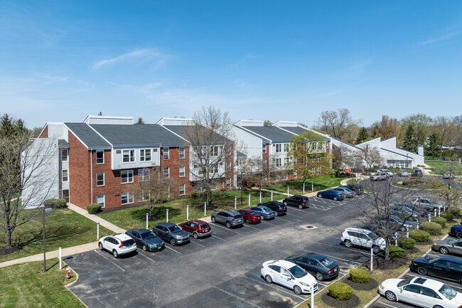
5905 Beechcroft Rd
010-011278
5905 BEECHCROFT RD R18T2 1/4T4 7.426 ACRES
Retirementnursinghomecombined
Franklin
B and X Area of moderate flood hazard, usually the area between the limits of the 100-year and 500-year floods.
Ohio
2024
7.43 AC
2025
Northgate
006945
Columbus
83,672 SF
Columbus, OH
NEARBY LISTINGS FOR SALE OR LEASE
-
-
View all Columbus listings for sale on LoopNet.com
DEMOGRAPHICS near 5905 Beechcroft Rd
1 mile
3 mile
5 mile
2025 Total Population
21,259
134,088
301,417
2030 Population
21,630
136,914
310,081
Pop Growth 2025-2030
+ 1.75%
+ 2.11%
+ 2.87%
Average Age
38
37
38
2025 Total Households
8,287
52,768
123,615
HH Growth 2025-2030
+ 1.89%
+ 2.25%
+ 3.06%
Median Household Inc
$55,765
$64,801
$76,512
Avg Household Size
2.50
2.50
2.40
2025 Avg HH Vehicles
2.00
2.00
2.00
Median Home Value
$221,946
$260,557
$311,150
Median Year Built
1971
1973
1975
Nearby Places
Map Layers
Map Styles
 Street
 Aerial
Layers
 Traffic
 Biking
Places
Listings with unknown addresses are not visible on the map
- Restaurants
- Banks
- Shops
- Fitness
- Groceries
PUBLIC TRANSPORTATION
AIRPORT
John Glenn Columbus International
Drive
Walk
Distance
John Glenn Columbus International
20 min
10.6 mi
Rickenbacker International
Drive
Walk
Distance
Rickenbacker International
37 min
24.5 mi
Nearby Properties
Address
Land Use
TOTAL SIZE
Lot Size
Zoning
Address
Land Use
TOTAL SIZE
Lot Size
Zoning
440,828 SF
13.72 AC
Address
Land Use
TOTAL SIZE
Lot Size
Zoning
426,490 SF
19.43 AC
Address
Land Use
TOTAL SIZE
Lot Size
Zoning
206,724 SF
7.60 AC
Address
Land Use
TOTAL SIZE
Lot Size
Zoning
697,077 SF
40.91 AC
Address
Land Use
TOTAL SIZE
Lot Size
Zoning
159,315 SF
13.25 AC
Address
Land Use
TOTAL SIZE
Lot Size
Zoning
152,684 SF
20.94 AC
Address
Land Use
TOTAL SIZE
Lot Size
Zoning
201,072 SF
22.28 AC
Address
Land Use
TOTAL SIZE
Lot Size
Zoning
292,377 SF
36.29 AC
Address
Land Use
TOTAL SIZE
Lot Size
Zoning
142,998 SF
30.25 AC
Address
Land Use
TOTAL SIZE
Lot Size
Zoning
167,479 SF
36.79 AC
Address
Land Use
TOTAL SIZE
Lot Size
Zoning
273,264 SF
7.35 AC
Address
Land Use
TOTAL SIZE
Lot Size
Zoning
170,237 SF
97.38 AC
Address
Land Use
TOTAL SIZE
Lot Size
Zoning
368,077 SF
7.87 AC
Address
Land Use
TOTAL SIZE
Lot Size
Zoning
184,756 SF
23.53 AC
Address
Land Use
TOTAL SIZE
Lot Size
Zoning
358,264 SF
10.88 AC
Address
Land Use
TOTAL SIZE
Lot Size
Zoning
148.89 AC
Address
Land Use
TOTAL SIZE
Lot Size
Zoning
122,920 SF
20.30 AC
Address
Land Use
TOTAL SIZE
Lot Size
Zoning
362,014 SF
37.08 AC
Address
Land Use
TOTAL SIZE
Lot Size
Zoning
85,228 SF
45.03 AC
Address
Land Use
TOTAL SIZE
Lot Size
Zoning
30,383 SF
20.72 AC
Address
Land Use
TOTAL SIZE
Lot Size
Zoning
111,168 SF
19.43 AC
Address
Land Use
TOTAL SIZE
Lot Size
Zoning
74,544 SF
10.52 AC
Address
Land Use
TOTAL SIZE
Lot Size
Zoning
65,125 SF
11.98 AC
Address
Land Use
TOTAL SIZE
Lot Size
Zoning
174,736 SF
5.50 AC
Address
Land Use
TOTAL SIZE
Lot Size
Zoning
407,325 SF
27.53 AC
Address
Land Use
TOTAL SIZE
Lot Size
Zoning
35,172 SF
0.93 AC
Address
Land Use
TOTAL SIZE
Lot Size
Zoning
169,442 SF
7.76 AC
Address
Land Use
TOTAL SIZE
Lot Size
Zoning
130,059 SF
25.97 AC
Address
Land Use
TOTAL SIZE
Lot Size
Zoning
140,912 SF
36.59 AC
Address
Land Use
TOTAL SIZE
Lot Size
Zoning
161,281 SF
11.81 AC
The World's #1 Commercial Real Estate Marketplace
Connect with us
© 2026 CoStar Group
The information above has been obtained from sources believed reliable. While we do not doubt its accuracy we have not verified it and make no guarantee, warranty or representation about it. It is your responsibility to independently confirm its accuracy and completeness. Any projections, opinions, assumptions, or estimates used are for example only and do not represent the current or future performance of the property. The value of this transaction to you depends on tax and other factors which should be evaluated by your tax, financial, and legal advisors. You and your advisors should conduct a careful, independent investigation of the property to determine to your satisfaction the suitability of the property for your needs.