Property Record
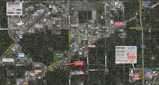
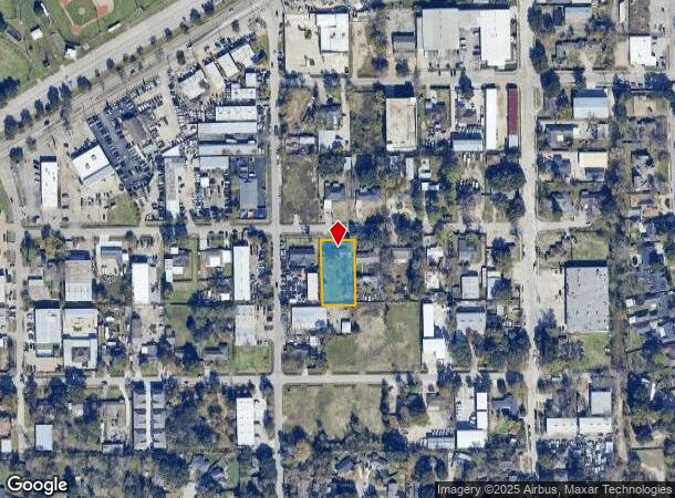
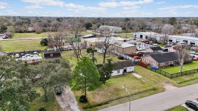
5905 Maple St, Houston, TX 77074
NEARBY LISTINGS FOR SALE OR LEASE
Property Detail
5905 Maple St
Houston-Pasadena-The Woodlands, TX
Braeburn Terrace Sec 1
0730230000068
Harris
Sfr
Texas
X
0.47 AC
48201C0855L
Southwest/Hillcroft
1,357 SF
Houston
DEMOGRAPHICS near 5905 Maple St
1 Mile
3 Mile
5 Mile
2024 Total Population
23,807
227,147
572,099
2029 Population
24,226
233,568
588,273
Pop Growth 2024-2029
+ 1.76%
+ 2.83%
+ 2.83%
Average Age
36
35
37
2024 Total Households
8,007
83,214
234,698
HH Growth 2024-2029
+ 1.69%
+ 2.76%
+ 2.86%
Median Household Inc
$48,753
$44,512
$53,347
Avg Household Size
2.80
2.60
2.40
2024 Avg HH Vehicles
2.00
2.00
1.00
Median Home Value
$257,764
$315,643
$324,319
Median Year Built
1966
1975
1980
Nearby Places
Map Layers
Map Styles
 Street
 Aerial
- Restaurants
- Banks
- Shops
- Fitness
- Groceries
PUBLIC TRANSPORTATION
AIRPORT
William P Hobby
DRIVE
WALK
Distance
William P Hobby
33 min
18.1 mi
George Bush Intcntl/Houston
DRIVE
WALK
Distance
George Bush Intcntl/Houston
41 min
30.5 mi
Freight Ports
Port of Houston
DRIVE
WALK
Distance
Port of Houston
30 min
18.3 mi
SALE & LEASE HISTORY
LISTING DATE
SALE/LEASE

May 12, 2023
For Sale
May 12, 2023
For Sale
May 12, 2023
For Sale
Mar 04, 2025
For Sale
Nearby Properties
Address
Land Use
TOTAL SIZE
Lot Size
Zoning
Address
Land Use
TOTAL SIZE
Lot Size
Zoning
777,791 SF
47.90 AC
Address
Land Use
TOTAL SIZE
Lot Size
Zoning
1,202,191 SF
39.08 AC
Address
Land Use
TOTAL SIZE
Lot Size
Zoning
1,612,349 SF
54.03 AC
Address
Land Use
TOTAL SIZE
Lot Size
Zoning
417,988 SF
15.70 AC
Address
Land Use
TOTAL SIZE
Lot Size
Zoning
807,423 SF
30.01 AC
Address
Land Use
TOTAL SIZE
Lot Size
Zoning
812,087 SF
28.58 AC
Address
Land Use
TOTAL SIZE
Lot Size
Zoning
188,178 SF
18.49 AC
Address
Land Use
TOTAL SIZE
Lot Size
Zoning
769,005 SF
20.46 AC
Address
Land Use
TOTAL SIZE
Lot Size
Zoning
544,698 SF
15.66 AC
Address
Land Use
TOTAL SIZE
Lot Size
Zoning
640,860 SF
5.31 AC
Address
Land Use
TOTAL SIZE
Lot Size
Zoning
398,772 SF
2.97 AC
Address
Land Use
TOTAL SIZE
Lot Size
Zoning
297,620 SF
11.01 AC
Address
Land Use
TOTAL SIZE
Lot Size
Zoning
290,624 SF
3.17 AC
Address
Land Use
TOTAL SIZE
Lot Size
Zoning
493,494 SF
13.54 AC
Address
Land Use
TOTAL SIZE
Lot Size
Zoning
456,076 SF
19.09 AC
Address
Land Use
TOTAL SIZE
Lot Size
Zoning
481,176 SF
18.15 AC
Address
Land Use
TOTAL SIZE
Lot Size
Zoning
87,017 SF
3.19 AC
Address
Land Use
TOTAL SIZE
Lot Size
Zoning
543,903 SF
5.11 AC
Address
Land Use
TOTAL SIZE
Lot Size
Zoning
414,014 SF
7.77 AC
Address
Land Use
TOTAL SIZE
Lot Size
Zoning
623,343 SF
22.89 AC
Address
Land Use
TOTAL SIZE
Lot Size
Zoning
287,776 SF
4.84 AC
Address
Land Use
TOTAL SIZE
Lot Size
Zoning
325,664 SF
14.16 AC
Address
Land Use
TOTAL SIZE
Lot Size
Zoning
434,744 SF
16.74 AC
Address
Land Use
TOTAL SIZE
Lot Size
Zoning
431,227 SF
15.51 AC
Address
Land Use
TOTAL SIZE
Lot Size
Zoning
396,594 SF
16.34 AC
Address
Land Use
TOTAL SIZE
Lot Size
Zoning
894,136 SF
12.51 AC
Address
Land Use
TOTAL SIZE
Lot Size
Zoning
391,070 SF
12.51 AC
Address
Land Use
TOTAL SIZE
Lot Size
Zoning
297,027 SF
4.56 AC
Address
Land Use
TOTAL SIZE
Lot Size
Zoning
349,982 SF
18.44 AC
Address
Land Use
TOTAL SIZE
Lot Size
Zoning
443,535 SF
13.14 AC
The World's #1 Commercial Real Estate Marketplace
Connect with us
© 2026 CoStar Group
The information above has been obtained from sources believed reliable. While we do not doubt its accuracy we have not verified it and make no guarantee, warranty or representation about it. It is your responsibility to independently confirm its accuracy and completeness. Any projections, opinions, assumptions, or estimates used are for example only and do not represent the current or future performance of the property. The value of this transaction to you depends on tax and other factors which should be evaluated by your tax, financial, and legal advisors. You and your advisors should conduct a careful, independent investigation of the property to determine to your satisfaction the suitability of the property for your needs.