Property Record
5905 N Illinois St, Fairview Heights, IL 62208

NEARBY LISTINGS FOR SALE OR LEASE
Property Detail
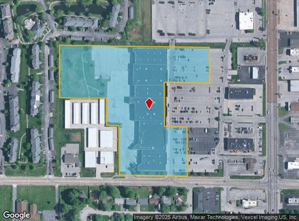
5905 N Illinois St
St. Louis, MO-IL
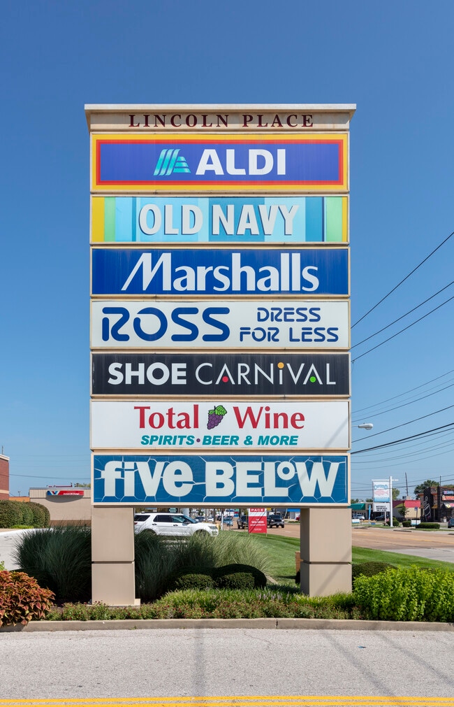
Lincoln Place
03-28.0-409-022
LINCOLN PLACE PHASE2 LOT/SEC-2 A02748784
Commercialnec
St. Clair
2024
Illinois
2024
10.78 AC
503416
Metro East Illinois
143,464 SF
St. Louis
DEMOGRAPHICS near 5905 N Illinois St
1 Mile
3 Mile
5 Mile
2024 Total Population
5,865
33,408
116,872
2029 Population
5,579
32,058
113,137
Pop Growth 2024-2029
(4.88%)
(4.04%)
(3.20%)
Average Age
42
42
41
2024 Total Households
2,610
13,972
48,650
HH Growth 2024-2029
(4.83%)
(4.04%)
(3.18%)
Median Household Inc
$71,336
$85,937
$74,018
Avg Household Size
2.20
2.40
2.30
2024 Avg HH Vehicles
2.00
2.00
2.00
Median Home Value
$153,833
$196,894
$170,726
Median Year Built
1979
1990
1977
Nearby Places
Map Layers
Map Styles
 Street
 Aerial
- Restaurants
- Banks
- Shops
- Fitness
- Groceries
PUBLIC TRANSPORTATION
COMMUTER RAIL
Memorial Hospital (Lambert Airport Shiloh-Scott - St. Louis MetroLink (MetroLink))
DRIVE
WALK
Distance
Memorial Hospital (Lambert Airport Shiloh-Scott - St. Louis MetroLink (MetroLink))
6 min
3.4 mi
Swansea (Lambert Airport Shiloh-Scott - St. Louis MetroLink (MetroLink))
DRIVE
WALK
Distance
Swansea (Lambert Airport Shiloh-Scott - St. Louis MetroLink (MetroLink))
7 min
3.8 mi
AIRPORT
Scott AFB/Midamerica St Louis
DRIVE
WALK
Distance
Scott AFB/Midamerica St Louis
25 min
13.7 mi
St Louis Lambert International
DRIVE
WALK
Distance
St Louis Lambert International
39 min
26.8 mi
SALE & LEASE HISTORY
LISTING DATE
SALE/LEASE

May 09, 2018
For Lease
Nearby Properties
Address
Land Use
TOTAL SIZE
Lot Size
Zoning
Address
Land Use
TOTAL SIZE
Lot Size
Zoning
Address
Land Use
TOTAL SIZE
Lot Size
Zoning
21.84 AC
Address
Land Use
TOTAL SIZE
Lot Size
Zoning
Address
Land Use
TOTAL SIZE
Lot Size
Zoning
2,484 SF
16.76 AC
Address
Land Use
TOTAL SIZE
Lot Size
Zoning
13,440 SF
14.07 AC
Address
Land Use
TOTAL SIZE
Lot Size
Zoning
2,937 SF
16.68 AC
Address
Land Use
TOTAL SIZE
Lot Size
Zoning
207,910 SF
13.42 AC
Address
Land Use
TOTAL SIZE
Lot Size
Zoning
30.86 AC
Address
Land Use
TOTAL SIZE
Lot Size
Zoning
Address
Land Use
TOTAL SIZE
Lot Size
Zoning
6,172 SF
7.31 AC
Address
Land Use
TOTAL SIZE
Lot Size
Zoning
5,772 SF
11.48 AC
Address
Land Use
TOTAL SIZE
Lot Size
Zoning
29,906 SF
4.24 AC
Address
Land Use
TOTAL SIZE
Lot Size
Zoning
140,850 SF
16.71 AC
Address
Land Use
TOTAL SIZE
Lot Size
Zoning
142,369 SF
12.01 AC
Address
Land Use
TOTAL SIZE
Lot Size
Zoning
1,863 SF
11.46 AC
Address
Land Use
TOTAL SIZE
Lot Size
Zoning
127,251 SF
12.15 AC
Address
Land Use
TOTAL SIZE
Lot Size
Zoning
7,004 SF
9.59 AC
Address
Land Use
TOTAL SIZE
Lot Size
Zoning
7.82 AC
Address
Land Use
TOTAL SIZE
Lot Size
Zoning
74,479 SF
5.96 AC
Address
Land Use
TOTAL SIZE
Lot Size
Zoning
15,888 SF
20.30 AC
Address
Land Use
TOTAL SIZE
Lot Size
Zoning
Address
Land Use
TOTAL SIZE
Lot Size
Zoning
3.57 AC
Address
Land Use
TOTAL SIZE
Lot Size
Zoning
113,880 SF
10.22 AC
Address
Land Use
TOTAL SIZE
Lot Size
Zoning
10,014 SF
3.18 AC
Address
Land Use
TOTAL SIZE
Lot Size
Zoning
64,752 SF
5.57 AC
Address
Land Use
TOTAL SIZE
Lot Size
Zoning
45,378 SF
0.92 AC
Address
Land Use
TOTAL SIZE
Lot Size
Zoning
16,682 SF
2.48 AC
Address
Land Use
TOTAL SIZE
Lot Size
Zoning
6,974 SF
6.14 AC
Address
Land Use
TOTAL SIZE
Lot Size
Zoning
11,005 SF
7.71 AC
The World's #1 Commercial Real Estate Marketplace
Connect with us
© 2026 CoStar Group
The information above has been obtained from sources believed reliable. While we do not doubt its accuracy we have not verified it and make no guarantee, warranty or representation about it. It is your responsibility to independently confirm its accuracy and completeness. Any projections, opinions, assumptions, or estimates used are for example only and do not represent the current or future performance of the property. The value of this transaction to you depends on tax and other factors which should be evaluated by your tax, financial, and legal advisors. You and your advisors should conduct a careful, independent investigation of the property to determine to your satisfaction the suitability of the property for your needs.