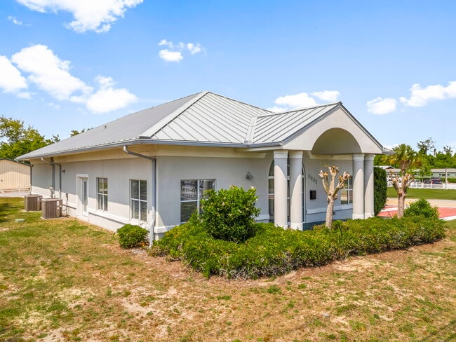
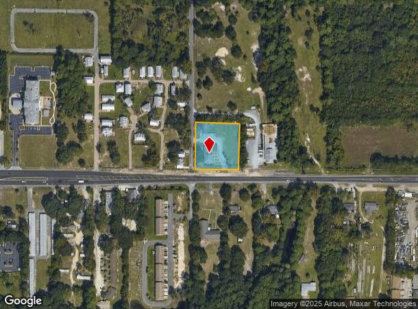
Property Record
5907 E Highway 22, Panama City, FL 32404
Current Lease Availabilities
NEARBY LISTINGS FOR SALE OR LEASE
Property Detail
5907 E Highway 22
Panama City, FL
St And Bay Dev Co Plat
06259-030-000
7 4S 13W -192.4- 131C2 ST AND BAY DEV CO PLAT COM AT SW COR OF SE1/4 OF NW1/4 N 108.30 TO N R/W HWY 22 E 15 TO W LINE LOT 59 TH N 250 E 219.75 S 250 TO N R/W SR #22 W 219.75 TO POB BEING PART OF LOTS 59 & 54 ORB 1759 P 1287 ORB 2093 P 1989 ORB 2132 P
Officebuilding
Bay
X
Florida
12005C0364J
59
2023
1.26 AC
2024
Panama City
000803
Other Market Areas
2,120 SF
DEMOGRAPHICS near 5907 E Highway 22
1 Mile
3 Mile
5 Mile
2024 Total Population
6,282
30,138
49,397
2029 Population
6,761
32,369
53,233
Pop Growth 2024-2029
+ 7.62%
+ 7.40%
+ 7.77%
Average Age
38
39
39
2024 Total Households
2,334
11,310
18,568
HH Growth 2024-2029
+ 8.14%
+ 7.96%
+ 8.28%
Median Household Inc
$47,105
$51,924
$52,799
Avg Household Size
2.60
2.60
2.50
2024 Avg HH Vehicles
2.00
2.00
2.00
Median Home Value
$144,333
$158,529
$171,382
Median Year Built
1984
1984
1984
Nearby Places
- Restaurants
- Banks
- Shops
- Fitness
- Groceries
PUBLIC TRANSPORTATION
AIRPORT
Northwest Florida Beaches International
DRIVE
WALK
Distance
Northwest Florida Beaches International
42 min
27.2 mi
Nearby Properties
Address
Land Use
TOTAL SIZE
Lot Size
Zoning
Address
Land Use
TOTAL SIZE
Lot Size
Zoning
226,068 SF
12.80 AC
Address
Land Use
TOTAL SIZE
Lot Size
Zoning
263,872 SF
41.43 AC
PC12
Address
Land Use
TOTAL SIZE
Lot Size
Zoning
415,651 SF
266 AC
BC13
Address
Land Use
TOTAL SIZE
Lot Size
Zoning
424,813 SF
30 AC
Address
Land Use
TOTAL SIZE
Lot Size
Zoning
143,208 SF
5.45 AC
Address
Land Use
TOTAL SIZE
Lot Size
Zoning
60,670 SF
15 AC
Address
Land Use
TOTAL SIZE
Lot Size
Zoning
107,778 SF
10 AC
Address
Land Use
TOTAL SIZE
Lot Size
Zoning
38,860 SF
4.32 AC
Address
Land Use
TOTAL SIZE
Lot Size
Zoning
74,914 SF
14.23 AC
BC02
Address
Land Use
TOTAL SIZE
Lot Size
Zoning
181,571 SF
22.29 AC
CLWY04
Address
Land Use
TOTAL SIZE
Lot Size
Zoning
39,628 SF
4.45 AC
CLWY04
Address
Land Use
TOTAL SIZE
Lot Size
Zoning
126,164 SF
9.81 AC
R5
Address
Land Use
TOTAL SIZE
Lot Size
Zoning
46,368 SF
2.30 AC
CLWY23
Address
Land Use
TOTAL SIZE
Lot Size
Zoning
39,456 SF
8.70 AC
Address
Land Use
TOTAL SIZE
Lot Size
Zoning
40,264 SF
2 AC
CLWY04
Address
Land Use
TOTAL SIZE
Lot Size
Zoning
55,300 SF
10.91 AC
PC12
Address
Land Use
TOTAL SIZE
Lot Size
Zoning
68,401 SF
30 AC
Address
Land Use
TOTAL SIZE
Lot Size
Zoning
39,298 SF
15.40 AC
PI
Address
Land Use
TOTAL SIZE
Lot Size
Zoning
74,996 SF
10 AC
PI
Address
Land Use
TOTAL SIZE
Lot Size
Zoning
42,456 SF
3.90 AC
CLWY04
Address
Land Use
TOTAL SIZE
Lot Size
Zoning
45,403 SF
2.65 AC
CLWY04
Address
Land Use
TOTAL SIZE
Lot Size
Zoning
48,576 SF
5.20 AC
CLWY23
Address
Land Use
TOTAL SIZE
Lot Size
Zoning
43,530 SF
10.70 AC
PC11
Address
Land Use
TOTAL SIZE
Lot Size
Zoning
128,098 SF
0.10 AC
Address
Land Use
TOTAL SIZE
Lot Size
Zoning
24,000 SF
5.85 AC
C3A
Address
Land Use
TOTAL SIZE
Lot Size
Zoning
118,902 SF
33.66 AC
BC13
Address
Land Use
TOTAL SIZE
Lot Size
Zoning
130,502 SF
3.46 AC
PC09
Address
Land Use
TOTAL SIZE
Lot Size
Zoning
70,028 SF
6.64 AC
CLWY04
Address
Land Use
TOTAL SIZE
Lot Size
Zoning
90,684 SF
15.59 AC
CLWY08
Address
Land Use
TOTAL SIZE
Lot Size
Zoning
21,088 SF
40 AC
CLWY12
The World's #1 Commercial Real Estate Marketplace
Connect with us
© 2025 CoStar Group
The information above has been obtained from sources believed reliable. While we do not doubt its accuracy we have not verified it and make no guarantee, warranty or representation about it. It is your responsibility to independently confirm its accuracy and completeness. Any projections, opinions, assumptions, or estimates used are for example only and do not represent the current or future performance of the property. The value of this transaction to you depends on tax and other factors which should be evaluated by your tax, financial, and legal advisors. You and your advisors should conduct a careful, independent investigation of the property to determine to your satisfaction the suitability of the property for your needs.