Property Record
591 Wilmer Ave, Cincinnati, OH 45226
NEARBY LISTINGS FOR SALE OR LEASE
-
-
View all Cincinnati listings for sale on LoopNet.com
Property Detail
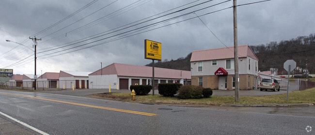
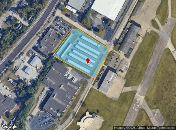
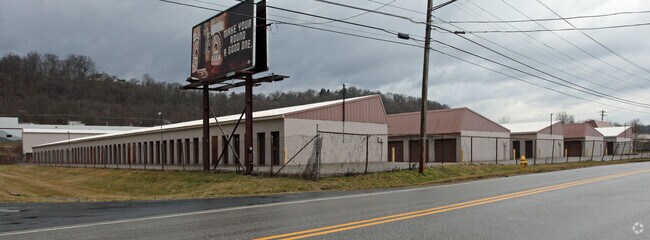
591 Wilmer Ave
Cincinnati, OH-KY-IN
Longworth Turkey Bottom Sub
014-0003-0005
WILMER AV 3.503AC R2-T4-S19 PT LOT 50-51-54LONGWORTH TURKEY BOTTOM SUB PAR 5-7-8 CON
Publicstorage
Hamilton
AE
Ohio
39061C0356G
50-51
2024
3.50 AC
2024
Fairfax/Mt. Lookout
004703
Cincinnati/Dayton
46,409 SF
DEMOGRAPHICS near 591 Wilmer Ave
1 Mile
3 Mile
5 Mile
2024 Total Population
2,970
62,337
230,627
2029 Population
2,946
61,872
230,981
Pop Growth 2024-2029
(0.81%)
(0.75%)
+ 0.15%
Average Age
38
40
39
2024 Total Households
1,383
28,684
104,434
HH Growth 2024-2029
(0.94%)
(0.95%)
+ 0.11%
Median Household Inc
$91,704
$95,644
$70,932
Avg Household Size
2.00
2.10
2.10
2024 Avg HH Vehicles
2.00
2.00
2.00
Median Home Value
$379,261
$331,564
$263,543
Median Year Built
1947
1952
1952
Nearby Places
Map Layers
Map Styles
 Street
 Aerial
- Restaurants
- Banks
- Shops
- Fitness
- Groceries
PUBLIC TRANSPORTATION
COMMUTER RAIL
Cincinnati Union Terminal (Cardinal - Amtrak)
DRIVE
WALK
Distance
Cincinnati Union Terminal (Cardinal - Amtrak)
18 min
9.0 mi
AIRPORT
Cincinnati/Northern Kentucky International
DRIVE
WALK
Distance
Cincinnati/Northern Kentucky International
37 min
20.5 mi
Freight Ports
Port of Toledo
DRIVE
WALK
Distance
Port of Toledo
248 min
208.6 mi
Nearby Properties
Address
Land Use
TOTAL SIZE
Lot Size
Zoning
Address
Land Use
TOTAL SIZE
Lot Size
Zoning
13.80 AC
Address
Land Use
TOTAL SIZE
Lot Size
Zoning
27.30 AC
M2
Address
Land Use
TOTAL SIZE
Lot Size
Zoning
11.68 AC
Address
Land Use
TOTAL SIZE
Lot Size
Zoning
26,453 SF
19.91 AC
M2
Address
Land Use
TOTAL SIZE
Lot Size
Zoning
60,772 SF
0.78 AC
Address
Land Use
TOTAL SIZE
Lot Size
Zoning
148,748 SF
24.90 AC
CGA
Address
Land Use
TOTAL SIZE
Lot Size
Zoning
12.46 AC
Address
Land Use
TOTAL SIZE
Lot Size
Zoning
89,925 SF
1.72 AC
Address
Land Use
TOTAL SIZE
Lot Size
Zoning
83,122 SF
1.99 AC
Address
Land Use
TOTAL SIZE
Lot Size
Zoning
24,572 SF
4.70 AC
Address
Land Use
TOTAL SIZE
Lot Size
Zoning
3,864 SF
0.15 AC
PD
Address
Land Use
TOTAL SIZE
Lot Size
Zoning
33,468 SF
1.04 AC
Address
Land Use
TOTAL SIZE
Lot Size
Zoning
2.17 AC
O
Address
Land Use
TOTAL SIZE
Lot Size
Zoning
9,515 SF
19.13 AC
Address
Land Use
TOTAL SIZE
Lot Size
Zoning
84,028 SF
0.52 AC
Address
Land Use
TOTAL SIZE
Lot Size
Zoning
81,670 SF
12.50 AC
SF20
Address
Land Use
TOTAL SIZE
Lot Size
Zoning
259.50 AC
RFR
Address
Land Use
TOTAL SIZE
Lot Size
Zoning
11.04 AC
SF20
Address
Land Use
TOTAL SIZE
Lot Size
Zoning
3,030 SF
0.80 AC
Address
Land Use
TOTAL SIZE
Lot Size
Zoning
20.38 AC
Address
Land Use
TOTAL SIZE
Lot Size
Zoning
31,650 SF
14 AC
SF10
Address
Land Use
TOTAL SIZE
Lot Size
Zoning
182,404 SF
1.45 AC
RM07
Address
Land Use
TOTAL SIZE
Lot Size
Zoning
0.38 AC
Address
Land Use
TOTAL SIZE
Lot Size
Zoning
Address
Land Use
TOTAL SIZE
Lot Size
Zoning
8.99 AC
Address
Land Use
TOTAL SIZE
Lot Size
Zoning
3.82 AC
RM20
Address
Land Use
TOTAL SIZE
Lot Size
Zoning
8.98 AC
SF6
Address
Land Use
TOTAL SIZE
Lot Size
Zoning
19.33 AC
OG
Address
Land Use
TOTAL SIZE
Lot Size
Zoning
21.90 AC
SF6
Address
Land Use
TOTAL SIZE
Lot Size
Zoning
4,332 SF
5.67 AC
The World's #1 Commercial Real Estate Marketplace
Connect with us
© 2025 CoStar Group
The information above has been obtained from sources believed reliable. While we do not doubt its accuracy we have not verified it and make no guarantee, warranty or representation about it. It is your responsibility to independently confirm its accuracy and completeness. Any projections, opinions, assumptions, or estimates used are for example only and do not represent the current or future performance of the property. The value of this transaction to you depends on tax and other factors which should be evaluated by your tax, financial, and legal advisors. You and your advisors should conduct a careful, independent investigation of the property to determine to your satisfaction the suitability of the property for your needs.