Property Record
5910 Hampton St, Melrose, FL 32666
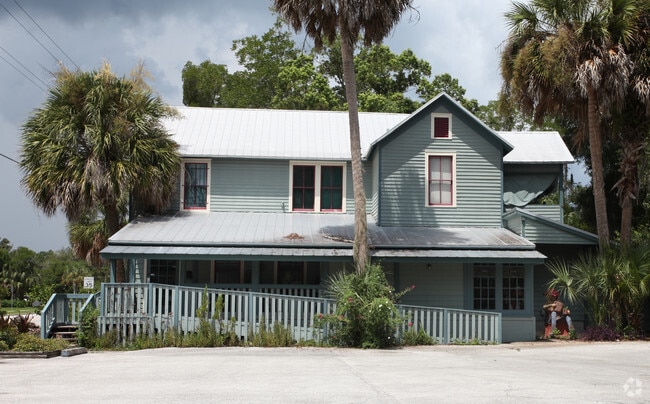


Property Detail
5910 Hampton St
18710-000-000
SIMS SURVEY DB J-847-848 S1/2 OF LOT 26 & LOT 27 & E 25 FT OF LOTS 28 29 OR 5113/1601
Officebuilding
Alachua
BR
Florida
B and X Area of moderate flood hazard, usually the area between the limits of the 100-year and 500-year floods.
0.26 AC
2025
Gainesville
2025
Other Market Areas
001907
Gainesville, FL
4,009 SF
NEARBY LISTINGS FOR SALE OR LEASE
-
-
View all Melrose listings for sale on LoopNet.com
DEMOGRAPHICS near 5910 Hampton St
1 mile
3 mile
5 mile
2025 Total Population
1,098
3,814
10,641
2030 Population
1,172
4,085
11,461
Pop Growth 2025-2030
+ 6.74%
+ 7.11%
+ 7.71%
Average Age
48
47
46
2025 Total Households
476
1,640
4,498
HH Growth 2025-2030
+ 6.93%
+ 7.32%
+ 7.78%
Median Household Inc
$68,164
$69,694
$70,082
Avg Household Size
2.30
2.30
2.30
2025 Avg HH Vehicles
2.00
2.00
2.00
Median Home Value
$279,869
$283,469
$297,206
Median Year Built
1985
1986
1985
Nearby Places
Map Layers
Map Styles
 Street
 Aerial
Transit
 Traffic
 Biking
Places
Listings with unknown addresses are not visible on the map
- Restaurants
- Banks
- Shops
- Fitness
- Groceries
PUBLIC TRANSPORTATION
AIRPORT
Gainesville Regional
Drive
Walk
Distance
Gainesville Regional
24 min
15.4 mi
Freight Ports
Jacksonville Port
Drive
Walk
Distance
Jacksonville Port
93 min
72.2 mi
SALE & LEASE HISTORY
LISTING DATE
SALE/LEASE

Sep 23, 2020
For Sale
Nearby Properties
Address
Land Use
TOTAL SIZE
Lot Size
Zoning
Address
Land Use
TOTAL SIZE
Lot Size
Zoning
13,727 SF
10.81 AC
Address
Land Use
TOTAL SIZE
Lot Size
Zoning
2,400 SF
15.62 AC
Address
Land Use
TOTAL SIZE
Lot Size
Zoning
2,556 SF
4.52 AC
Address
Land Use
TOTAL SIZE
Lot Size
Zoning
26,813 SF
2.08 AC
R-1A
Address
Land Use
TOTAL SIZE
Lot Size
Zoning
8,952 SF
2.49 AC
Address
Land Use
TOTAL SIZE
Lot Size
Zoning
4,284 SF
4.33 AC
Address
Land Use
TOTAL SIZE
Lot Size
Zoning
1,176 SF
1.77 AC
Address
Land Use
TOTAL SIZE
Lot Size
Zoning
9,440 SF
2.96 AC
Address
Land Use
TOTAL SIZE
Lot Size
Zoning
900 SF
1.03 AC
Address
Land Use
TOTAL SIZE
Lot Size
Zoning
4,031 SF
0.34 AC
BA
Address
Land Use
TOTAL SIZE
Lot Size
Zoning
1,984 SF
16.33 AC
Address
Land Use
TOTAL SIZE
Lot Size
Zoning
4,888 SF
0.62 AC
Address
Land Use
TOTAL SIZE
Lot Size
Zoning
1,992 SF
0.91 AC
Address
Land Use
TOTAL SIZE
Lot Size
Zoning
4,868 SF
1.95 AC
Address
Land Use
TOTAL SIZE
Lot Size
Zoning
3,526 SF
31.67 AC
Address
Land Use
TOTAL SIZE
Lot Size
Zoning
938 SF
8.95 AC
Address
Land Use
TOTAL SIZE
Lot Size
Zoning
1,224 SF
6.31 AC
Address
Land Use
TOTAL SIZE
Lot Size
Zoning
1.49 AC
Address
Land Use
TOTAL SIZE
Lot Size
Zoning
10,785 SF
4.73 AC
A
Address
Land Use
TOTAL SIZE
Lot Size
Zoning
2,046 SF
0.52 AC
Address
Land Use
TOTAL SIZE
Lot Size
Zoning
840 SF
1.36 AC
Address
Land Use
TOTAL SIZE
Lot Size
Zoning
3,774 SF
36.78 AC
Address
Land Use
TOTAL SIZE
Lot Size
Zoning
2,820 SF
1.30 AC
Address
Land Use
TOTAL SIZE
Lot Size
Zoning
7,502 SF
0.98 AC
R-1A
Address
Land Use
TOTAL SIZE
Lot Size
Zoning
2,592 SF
0.76 AC
Address
Land Use
TOTAL SIZE
Lot Size
Zoning
3,106 SF
0.59 AC
A
Address
Land Use
TOTAL SIZE
Lot Size
Zoning
744 SF
1.19 AC
Address
Land Use
TOTAL SIZE
Lot Size
Zoning
5,788 SF
2.26 AC
Address
Land Use
TOTAL SIZE
Lot Size
Zoning
8,176 SF
21.44 AC
The World's #1 Commercial Real Estate Marketplace
Connect with us
© 2026 CoStar Group
The information above has been obtained from sources believed reliable. While we do not doubt its accuracy we have not verified it and make no guarantee, warranty or representation about it. It is your responsibility to independently confirm its accuracy and completeness. Any projections, opinions, assumptions, or estimates used are for example only and do not represent the current or future performance of the property. The value of this transaction to you depends on tax and other factors which should be evaluated by your tax, financial, and legal advisors. You and your advisors should conduct a careful, independent investigation of the property to determine to your satisfaction the suitability of the property for your needs.