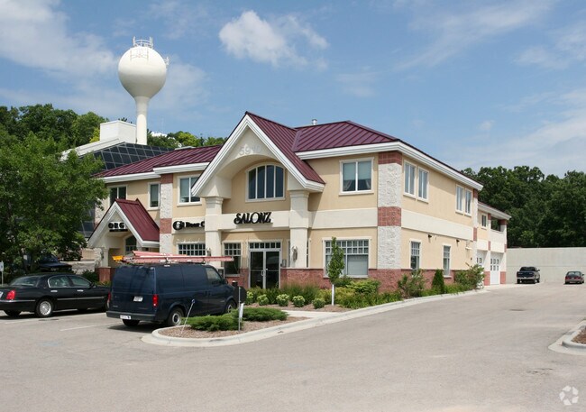
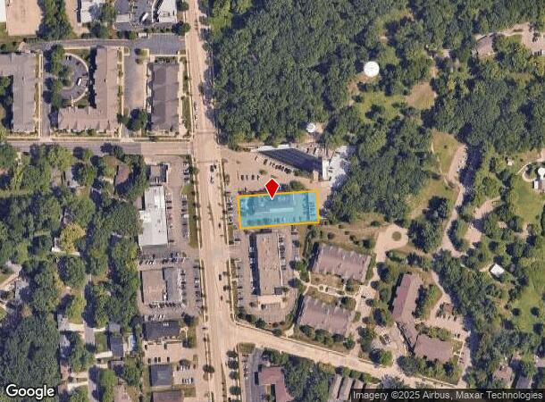
Property Record
5910 Monona Dr, Monona, WI 53716


NEARBY LISTINGS FOR SALE OR LEASE
Property Detail
5910 Monona Dr
Madison, WI
Assessors Plat No 13 Monona
0710-213-2362-7
PRT LOT 2 CSM 2774 CS11/79-4/3/78 F/K/A ASSESSORS PLAT NO 13 MONONA PRT LOT 1 DE SCR AS SEC 21-7-10 PRT NW1/4SW1/4 COM SEC 21-7-10 W1/4 COR TH N87DEGE 85.08 FT T H S4DEGE 150.52 FT TO POB TH N85DEGE 251.7 FT TH S4DEGE 100 FT TH S85DEGW 251.7 FT TH N4
Commercialnec
Dane
X
Wisconsin
55025C0437H
2,1
2024
0.58 AC
2024
Southeast Madison
002900
Milwaukee/Madison
DEMOGRAPHICS near 5910 Monona Dr
1 Mile
3 Mile
5 Mile
2024 Total Population
8,373
45,842
169,729
2029 Population
8,677
47,406
175,180
Pop Growth 2024-2029
+ 3.63%
+ 3.41%
+ 3.21%
Average Age
42
41
36
2024 Total Households
3,997
20,930
75,319
HH Growth 2024-2029
+ 3.75%
+ 3.53%
+ 3.46%
Median Household Inc
$68,188
$76,879
$62,850
Avg Household Size
2.00
2.10
2.00
2024 Avg HH Vehicles
2.00
2.00
1.00
Median Home Value
$287,231
$286,551
$300,262
Median Year Built
1966
1967
1974
Nearby Places
Map Layers
Map Styles
 Street
 Aerial
- Restaurants
- Banks
- Shops
- Fitness
- Groceries
PUBLIC TRANSPORTATION
AIRPORT
Dane County Regional/Truax Field
DRIVE
WALK
Distance
Dane County Regional/Truax Field
16 min
8.5 mi
Nearby Properties
Address
Land Use
TOTAL SIZE
Lot Size
Zoning
Address
Land Use
TOTAL SIZE
Lot Size
Zoning
168,685 SF
14.05 AC
IL
Address
Land Use
TOTAL SIZE
Lot Size
Zoning
13,440 SF
10.98 AC
IL
Address
Land Use
TOTAL SIZE
Lot Size
Zoning
216,017 SF
3.35 AC
TE
Address
Land Use
TOTAL SIZE
Lot Size
Zoning
2.03 AC
Address
Land Use
TOTAL SIZE
Lot Size
Zoning
13.40 AC
Address
Land Use
TOTAL SIZE
Lot Size
Zoning
3.59 AC
Address
Land Use
TOTAL SIZE
Lot Size
Zoning
73,125 SF
1.49 AC
HIS-TL
Address
Land Use
TOTAL SIZE
Lot Size
Zoning
12,450 SF
9.40 AC
SE
Address
Land Use
TOTAL SIZE
Lot Size
Zoning
2.38 AC
Address
Land Use
TOTAL SIZE
Lot Size
Zoning
4,992 SF
4.09 AC
SE
Address
Land Use
TOTAL SIZE
Lot Size
Zoning
19.81 AC
Address
Land Use
TOTAL SIZE
Lot Size
Zoning
149,897 SF
17.72 AC
IL
Address
Land Use
TOTAL SIZE
Lot Size
Zoning
5.53 AC
Address
Land Use
TOTAL SIZE
Lot Size
Zoning
3.49 AC
Address
Land Use
TOTAL SIZE
Lot Size
Zoning
6,868 SF
18.35 AC
IL
Address
Land Use
TOTAL SIZE
Lot Size
Zoning
202,800 SF
13.05 AC
IL
Address
Land Use
TOTAL SIZE
Lot Size
Zoning
94,290 SF
21.31 AC
SR-V2
Address
Land Use
TOTAL SIZE
Lot Size
Zoning
95,909 SF
1 AC
TE
Address
Land Use
TOTAL SIZE
Lot Size
Zoning
86,831 SF
2.73 AC
SE
Address
Land Use
TOTAL SIZE
Lot Size
Zoning
117,606 SF
1.85 AC
TR-U2
Address
Land Use
TOTAL SIZE
Lot Size
Zoning
16.40 AC
IL
Address
Land Use
TOTAL SIZE
Lot Size
Zoning
137,806 SF
1.80 AC
SE
Address
Land Use
TOTAL SIZE
Lot Size
Zoning
280,000 SF
15.01 AC
IL
Address
Land Use
TOTAL SIZE
Lot Size
Zoning
10.45 AC
IL
Address
Land Use
TOTAL SIZE
Lot Size
Zoning
78,300 SF
14.35 AC
CC
Address
Land Use
TOTAL SIZE
Lot Size
Zoning
49,562 SF
4.42 AC
SE
Address
Land Use
TOTAL SIZE
Lot Size
Zoning
6,492 SF
1.35 AC
SE
Address
Land Use
TOTAL SIZE
Lot Size
Zoning
134,814 SF
3.79 AC
SR-V2
Address
Land Use
TOTAL SIZE
Lot Size
Zoning
100,161 SF
27.20 AC
SE
Address
Land Use
TOTAL SIZE
Lot Size
Zoning
100,161 SF
27.20 AC
SE
The World's #1 Commercial Real Estate Marketplace
Connect with us
© 2025 CoStar Group
The information above has been obtained from sources believed reliable. While we do not doubt its accuracy we have not verified it and make no guarantee, warranty or representation about it. It is your responsibility to independently confirm its accuracy and completeness. Any projections, opinions, assumptions, or estimates used are for example only and do not represent the current or future performance of the property. The value of this transaction to you depends on tax and other factors which should be evaluated by your tax, financial, and legal advisors. You and your advisors should conduct a careful, independent investigation of the property to determine to your satisfaction the suitability of the property for your needs.