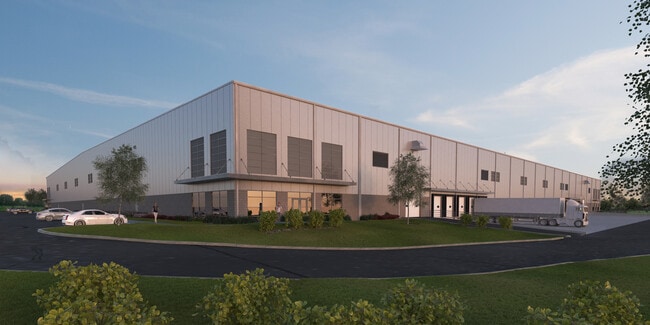
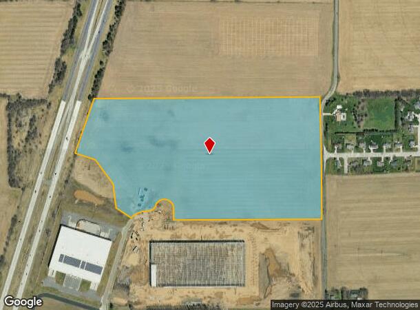
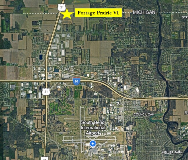
Property Record
5910 N Dylan Dr, South Bend, IN 46628
Current Lease Availabilities
NEARBY LISTINGS FOR SALE OR LEASE
Property Detail
5910 N Dylan Dr
South Bend-Mishawaka, IN-MI
N1/2 SW1/4 E OF HWY EX PORTAGE PRAIRIE BUS PARK PH 2 SEC 8 38 2E 23/24 NP 1346 7/20/22 23/24 VAC LOT 3 07/20/2022
71-03-08-326-007.000-009
St Joseph
Agriculturalland
Indiana
2023
174 SF
2024
Outlying St Joseph County
011001
South Bend/Mishawaka
DEMOGRAPHICS near 5910 N Dylan Dr
1 Mile
3 Mile
5 Mile
2024 Total Population
493
7,306
35,190
2029 Population
483
7,183
34,607
Pop Growth 2024-2029
(2.03%)
(1.68%)
(1.66%)
Average Age
43
44
42
2024 Total Households
197
2,912
14,263
HH Growth 2024-2029
(2.03%)
(1.82%)
(1.82%)
Median Household Inc
$102,083
$101,566
$63,528
Avg Household Size
2.40
2.40
2.40
2024 Avg HH Vehicles
2.00
2.00
2.00
Median Home Value
$192,472
$224,126
$166,359
Median Year Built
1994
1991
1969
Nearby Places
Map Layers
Map Styles
 Street
 Aerial
- Restaurants
- Banks
- Shops
- Fitness
- Groceries
PUBLIC TRANSPORTATION
COMMUTER RAIL
South Bend Amtrak Station (Capitol Limited - Amtrak, Lake Shore Limited - Amtrak)
DRIVE
WALK
Distance
South Bend Amtrak Station (Capitol Limited - Amtrak, Lake Shore Limited - Amtrak)
16 min
7.3 mi
South Bend Airport Station (South Shore Line - Northern Indiana Commuter Transportation District (South Shore Line))
DRIVE
WALK
Distance
South Bend Airport Station (South Shore Line - Northern Indiana Commuter Transportation District (South Shore Line))
14 min
7.7 mi
AIRPORT
South Bend International
DRIVE
WALK
Distance
South Bend International
21 min
7.9 mi
Freight Ports
Port Milwaukee
DRIVE
WALK
Distance
Port Milwaukee
216 min
177.3 mi
Nearby Properties
Address
Land Use
TOTAL SIZE
Lot Size
Zoning
Address
Land Use
TOTAL SIZE
Lot Size
Zoning
315,000 SF
131 SF
Address
Land Use
TOTAL SIZE
Lot Size
Zoning
356,520 SF
28.07 AC
Address
Land Use
TOTAL SIZE
Lot Size
Zoning
252,327 SF
131 SF
Address
Land Use
TOTAL SIZE
Lot Size
Zoning
232,200 SF
87 SF
Address
Land Use
TOTAL SIZE
Lot Size
Zoning
633,966 SF
87 SF
Address
Land Use
TOTAL SIZE
Lot Size
Zoning
296,370 SF
131 SF
Address
Land Use
TOTAL SIZE
Lot Size
Zoning
213,400 SF
44 SF
Address
Land Use
TOTAL SIZE
Lot Size
Zoning
166,500 SF
44 SF
Address
Land Use
TOTAL SIZE
Lot Size
Zoning
343,964 SF
131 SF
Address
Land Use
TOTAL SIZE
Lot Size
Zoning
225,000 SF
19.59 AC
Address
Land Use
TOTAL SIZE
Lot Size
Zoning
210,420 SF
131 SF
Address
Land Use
TOTAL SIZE
Lot Size
Zoning
212,497 SF
131 SF
Address
Land Use
TOTAL SIZE
Lot Size
Zoning
210,420 SF
131 SF
Address
Land Use
TOTAL SIZE
Lot Size
Zoning
111,803 SF
7.45 AC
Address
Land Use
TOTAL SIZE
Lot Size
Zoning
72,418 SF
131 SF
Address
Land Use
TOTAL SIZE
Lot Size
Zoning
79,451 SF
87 SF
Address
Land Use
TOTAL SIZE
Lot Size
Zoning
4,428 SF
0.02 AC
Address
Land Use
TOTAL SIZE
Lot Size
Zoning
203,750 SF
22.36 AC
Address
Land Use
TOTAL SIZE
Lot Size
Zoning
204,880 SF
44 SF
Address
Land Use
TOTAL SIZE
Lot Size
Zoning
165,000 SF
87 SF
Address
Land Use
TOTAL SIZE
Lot Size
Zoning
397,100 SF
45.61 AC
Address
Land Use
TOTAL SIZE
Lot Size
Zoning
84,398 SF
44 SF
Address
Land Use
TOTAL SIZE
Lot Size
Zoning
143,917 SF
87 SF
Address
Land Use
TOTAL SIZE
Lot Size
Zoning
266,881 SF
26.20 AC
Address
Land Use
TOTAL SIZE
Lot Size
Zoning
164,850 SF
44 SF
Address
Land Use
TOTAL SIZE
Lot Size
Zoning
499,104 SF
87 SF
Address
Land Use
TOTAL SIZE
Lot Size
Zoning
211,200 SF
44 SF
Address
Land Use
TOTAL SIZE
Lot Size
Zoning
143,890 SF
87 SF
Address
Land Use
TOTAL SIZE
Lot Size
Zoning
58,827 SF
131 SF
Address
Land Use
TOTAL SIZE
Lot Size
Zoning
152,807 SF
87 SF
The World's #1 Commercial Real Estate Marketplace
Connect with us
© 2025 CoStar Group
The information above has been obtained from sources believed reliable. While we do not doubt its accuracy we have not verified it and make no guarantee, warranty or representation about it. It is your responsibility to independently confirm its accuracy and completeness. Any projections, opinions, assumptions, or estimates used are for example only and do not represent the current or future performance of the property. The value of this transaction to you depends on tax and other factors which should be evaluated by your tax, financial, and legal advisors. You and your advisors should conduct a careful, independent investigation of the property to determine to your satisfaction the suitability of the property for your needs.