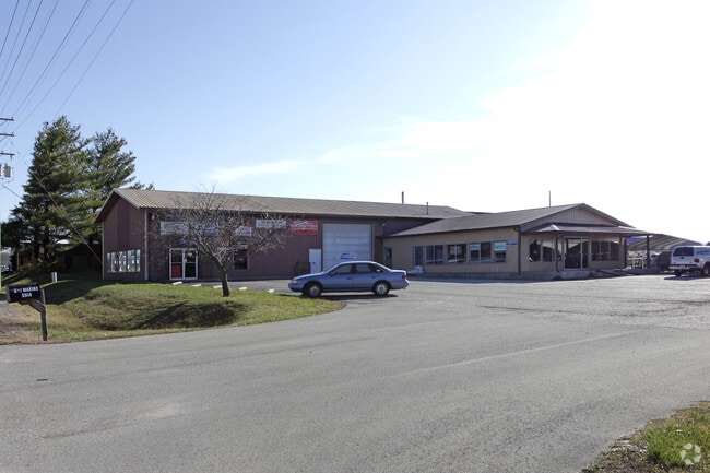
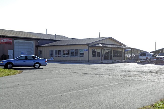
Property Record
5910 Poplar Level Rd, Louisville, KY 40228

NEARBY LISTINGS FOR SALE OR LEASE
Property Detail
5910 Poplar Level Rd
209100300000
Poplar Park
Storebuilding
1.035 AC +/- S SIDE POPLAR LEVEL RD, 195 FT E OF FERN VALLEY PASS
X
Jefferson
21111C0078F
Kentucky
2025
1.03 AC
2025
South Central
011521
Louisville
6,120 SF
Louisville-Jefferson County, KY-IN
DEMOGRAPHICS near 5910 Poplar Level Rd
1 Mile
3 Mile
5 Mile
2024 Total Population
8,298
85,165
211,505
2029 Population
8,127
84,084
208,396
Pop Growth 2024-2029
(2.06%)
(1.27%)
(1.47%)
Average Age
38
39
40
2024 Total Households
3,391
34,283
87,066
HH Growth 2024-2029
(2.12%)
(1.33%)
(1.55%)
Median Household Inc
$58,876
$56,850
$62,808
Avg Household Size
2.40
2.40
2.40
2024 Avg HH Vehicles
2.00
2.00
2.00
Median Home Value
$175,700
$177,292
$199,201
Median Year Built
1972
1972
1973
Nearby Places
Map Layers
Map Styles
 Street
 Aerial
- Restaurants
- Banks
- Shops
- Fitness
- Groceries
PUBLIC TRANSPORTATION
AIRPORT
Louisville Muhammad Ali International
DRIVE
WALK
Distance
Louisville Muhammad Ali International
14 min
7.1 mi
SALE & LEASE HISTORY
LISTING DATE
SALE/LEASE

Sep 14, 2023
For Lease
Nearby Properties
Address
Land Use
TOTAL SIZE
Lot Size
Zoning
Address
Land Use
TOTAL SIZE
Lot Size
Zoning
127,824 SF
53.76 AC
M2-INDUSTR
Address
Land Use
TOTAL SIZE
Lot Size
Zoning
19.16 AC
Address
Land Use
TOTAL SIZE
Lot Size
Zoning
32.44 AC
Address
Land Use
TOTAL SIZE
Lot Size
Zoning
14,166 SF
16.32 AC
C1-COMMERC
Address
Land Use
TOTAL SIZE
Lot Size
Zoning
407,840 SF
25.51 AC
C2-COMMERC
Address
Land Use
TOTAL SIZE
Lot Size
Zoning
4,745 SF
17.95 AC
Address
Land Use
TOTAL SIZE
Lot Size
Zoning
11.17 AC
R6-RESIDEN
Address
Land Use
TOTAL SIZE
Lot Size
Zoning
10.22 AC
C1-COMMERC
Address
Land Use
TOTAL SIZE
Lot Size
Zoning
5,200 SF
7.55 AC
R7-RESIDEN
Address
Land Use
TOTAL SIZE
Lot Size
Zoning
1,450 SF
87.64 AC
M2-INDUSTR
Address
Land Use
TOTAL SIZE
Lot Size
Zoning
401,443 SF
28.92 AC
M2-INDUSTR
Address
Land Use
TOTAL SIZE
Lot Size
Zoning
27.92 AC
EZ1-ENTERP
Address
Land Use
TOTAL SIZE
Lot Size
Zoning
16,836 SF
13.72 AC
R6-RESIDEN
Address
Land Use
TOTAL SIZE
Lot Size
Zoning
13.68 AC
Address
Land Use
TOTAL SIZE
Lot Size
Zoning
14,880 SF
12.98 AC
R6-RESIDEN
Address
Land Use
TOTAL SIZE
Lot Size
Zoning
15.24 AC
Address
Land Use
TOTAL SIZE
Lot Size
Zoning
370,297 SF
28.31 AC
M2-INDUSTR
Address
Land Use
TOTAL SIZE
Lot Size
Zoning
Address
Land Use
TOTAL SIZE
Lot Size
Zoning
17.17 AC
EZ1-ENTERP
Address
Land Use
TOTAL SIZE
Lot Size
Zoning
6,570 SF
7.06 AC
R7-RESIDEN
Address
Land Use
TOTAL SIZE
Lot Size
Zoning
3,654 SF
11.13 AC
R5A-RESIDE
Address
Land Use
TOTAL SIZE
Lot Size
Zoning
24,290 SF
14.88 AC
C2-COMMERC
Address
Land Use
TOTAL SIZE
Lot Size
Zoning
18.67 AC
Address
Land Use
TOTAL SIZE
Lot Size
Zoning
33,820 SF
11.87 AC
R6-RESIDEN
Address
Land Use
TOTAL SIZE
Lot Size
Zoning
4,000 SF
15.46 AC
C2-COMMERC
Address
Land Use
TOTAL SIZE
Lot Size
Zoning
14.13 AC
R4-RESIDEN
Address
Land Use
TOTAL SIZE
Lot Size
Zoning
15.08 AC
C1-COMMERC
Address
Land Use
TOTAL SIZE
Lot Size
Zoning
14,492 SF
9.07 AC
R7-RESIDEN
Address
Land Use
TOTAL SIZE
Lot Size
Zoning
2,120 SF
6.89 AC
R7-RESIDEN
Address
Land Use
TOTAL SIZE
Lot Size
Zoning
144,158 SF
17.32 AC
M3-INDUSTR
The World's #1 Commercial Real Estate Marketplace
Connect with us
© 2025 CoStar Group
The information above has been obtained from sources believed reliable. While we do not doubt its accuracy we have not verified it and make no guarantee, warranty or representation about it. It is your responsibility to independently confirm its accuracy and completeness. Any projections, opinions, assumptions, or estimates used are for example only and do not represent the current or future performance of the property. The value of this transaction to you depends on tax and other factors which should be evaluated by your tax, financial, and legal advisors. You and your advisors should conduct a careful, independent investigation of the property to determine to your satisfaction the suitability of the property for your needs.