Property Record
5912 Waseca St, Duluth, MN 55807
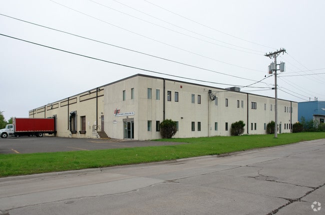

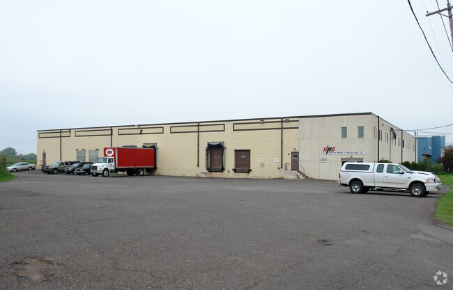
Property Detail
5912 Waseca St
Duluth, MN-WI
ALL OF BLOCK 288, INCLUDING THE E1/2 OFVACATED ALLEY BETWEEN BLOCKS 287 AND 288,WEST DULUTH FOURTH DIVISION; AND LOTS 1THROUGH 4 AND WESTERLY 50 FEET OF LOTS 5THROUGH 16, BLOCK 289, INCLUDING THE VACATEDPORTION OF 60TH AVENUE WEST, LYING BETWEEN SERI
010450005840
Saint Louis
Manufacturinglight
Minnesota
B and X Area of moderate flood hazard, usually the area between the limits of the 100-year and 500-year floods.
1-2
2026
0.19 AC
2024
West End
015800
Duluth
34,163 SF
NEARBY LISTINGS FOR SALE OR LEASE
DEMOGRAPHICS near 5912 Waseca St
1 mile
3 mile
5 mile
2025 Total Population
3,493
19,481
51,120
2030 Population
3,376
19,035
50,280
Pop Growth 2025-2030
(3.35%)
(2.29%)
(1.64%)
Average Age
40
41
40
2025 Total Households
1,561
8,483
22,387
HH Growth 2025-2030
(3.52%)
(2.39%)
(1.70%)
Median Household Inc
$51,786
$66,896
$61,085
Avg Household Size
2.10
2.20
2.10
2025 Avg HH Vehicles
2.00
2.00
2.00
Median Home Value
$168,736
$188,213
$204,065
Median Year Built
1947
1948
1951
Nearby Places
Map Layers
Map Styles
 Street
 Aerial
Layers
 Traffic
 Biking
Places
Listings with unknown addresses are not visible on the map
- Restaurants
- Banks
- Shops
- Fitness
- Groceries
PUBLIC TRANSPORTATION
AIRPORT
Duluth International
Drive
Walk
Distance
Duluth International
26 min
11.2 mi
Nearby Properties
Address
Land Use
TOTAL SIZE
Lot Size
Zoning
Address
Land Use
TOTAL SIZE
Lot Size
Zoning
328,704 SF
3.81 AC
Address
Land Use
TOTAL SIZE
Lot Size
Zoning
391,335 SF
53.53 AC
Address
Land Use
TOTAL SIZE
Lot Size
Zoning
175 AC
W1
Address
Land Use
TOTAL SIZE
Lot Size
Zoning
93,584 SF
0.66 AC
Address
Land Use
TOTAL SIZE
Lot Size
Zoning
87,768 SF
2.42 AC
Address
Land Use
TOTAL SIZE
Lot Size
Zoning
107,796 SF
9.19 AC
Address
Land Use
TOTAL SIZE
Lot Size
Zoning
1,200 SF
10.74 AC
Address
Land Use
TOTAL SIZE
Lot Size
Zoning
52.06 AC
M2
Address
Land Use
TOTAL SIZE
Lot Size
Zoning
24,389 SF
1.68 AC
Address
Land Use
TOTAL SIZE
Lot Size
Zoning
557,127 SF
37 AC
Address
Land Use
TOTAL SIZE
Lot Size
Zoning
185,313 SF
Address
Land Use
TOTAL SIZE
Lot Size
Zoning
73,973 SF
2.84 AC
Address
Land Use
TOTAL SIZE
Lot Size
Zoning
96,000 SF
1.35 AC
Address
Land Use
TOTAL SIZE
Lot Size
Zoning
169,373 SF
6.54 AC
Address
Land Use
TOTAL SIZE
Lot Size
Zoning
6.01 AC
M2
Address
Land Use
TOTAL SIZE
Lot Size
Zoning
17,638 SF
5.37 AC
Address
Land Use
TOTAL SIZE
Lot Size
Zoning
24,555 SF
1.14 AC
Address
Land Use
TOTAL SIZE
Lot Size
Zoning
71,291 SF
0.61 AC
TND
Address
Land Use
TOTAL SIZE
Lot Size
Zoning
3.42 AC
R3
Address
Land Use
TOTAL SIZE
Lot Size
Zoning
76,000 SF
36.67 AC
Address
Land Use
TOTAL SIZE
Lot Size
Zoning
7.05 AC
M2
Address
Land Use
TOTAL SIZE
Lot Size
Zoning
50,096 SF
5.99 AC
Address
Land Use
TOTAL SIZE
Lot Size
Zoning
4.47 AC
Address
Land Use
TOTAL SIZE
Lot Size
Zoning
83,290 SF
0.58 AC
C2
Address
Land Use
TOTAL SIZE
Lot Size
Zoning
24,873 SF
73.59 AC
Address
Land Use
TOTAL SIZE
Lot Size
Zoning
40,088 SF
Address
Land Use
TOTAL SIZE
Lot Size
Zoning
38,017 SF
0.92 AC
Address
Land Use
TOTAL SIZE
Lot Size
Zoning
38,160 SF
2.28 AC
Address
Land Use
TOTAL SIZE
Lot Size
Zoning
38,160 SF
1.97 AC
The World's #1 Commercial Real Estate Marketplace
Connect with us
© 2026 CoStar Group
The information above has been obtained from sources believed reliable. While we do not doubt its accuracy we have not verified it and make no guarantee, warranty or representation about it. It is your responsibility to independently confirm its accuracy and completeness. Any projections, opinions, assumptions, or estimates used are for example only and do not represent the current or future performance of the property. The value of this transaction to you depends on tax and other factors which should be evaluated by your tax, financial, and legal advisors. You and your advisors should conduct a careful, independent investigation of the property to determine to your satisfaction the suitability of the property for your needs.