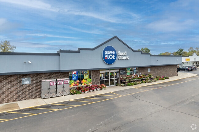
Property Record
5914 E State Road 10, Demotte, IN 46310

Property Detail
5914 E State Road 10
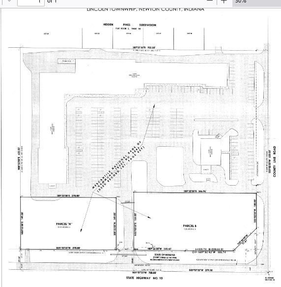
56-05-12-444-015.000-013
PT E1/2 SE SEC 12 T31N R8W 8.254 ACRES LINCOLN TWP MP 04-12-444-015.00
Stripcommercialcenter
NEWTON
B and X Area of moderate flood hazard, usually the area between the limits of the 100-year and 500-year floods.
Indiana
2025
8.25 AC
2025
Newton County
100902
Chicago
57,905 SF
Chicago-Naperville-Elgin, IL-IN
NEARBY LISTINGS FOR SALE OR LEASE
DEMOGRAPHICS near 5914 E State Road 10
1 mile
3 mile
5 mile
2025 Total Population
1,672
5,554
10,421
2030 Population
1,699
5,638
10,562
Pop Growth 2025-2030
+ 1.61%
+ 1.51%
+ 1.35%
Average Age
40
41
41
2025 Total Households
618
2,050
3,918
HH Growth 2025-2030
+ 1.62%
+ 1.51%
+ 1.38%
Median Household Inc
$83,715
$81,600
$76,989
Avg Household Size
2.70
2.70
2.60
2025 Avg HH Vehicles
3.00
3.00
2.00
Median Home Value
$195,127
$218,047
$229,515
Median Year Built
1979
1983
1990
Nearby Places
Map Layers
Map Styles
 Street
 Aerial
Layers
 Traffic
 Biking
Places
Listings with unknown addresses are not visible on the map
- Restaurants
- Banks
- Shops
- Fitness
- Groceries
SALE & LEASE HISTORY
LISTING DATE
SALE/LEASE

Sep 25, 2016
For Lease
Nov 15, 2017
For Lease
Jan 23, 2025
For Sale
Apr 13, 2018
For Lease
Nearby Properties
Address
Land Use
TOTAL SIZE
Lot Size
Zoning
Address
Land Use
TOTAL SIZE
Lot Size
Zoning
20,379 SF
50 AC
HC
Address
Land Use
TOTAL SIZE
Lot Size
Zoning
2,188 SF
93.60 AC
A3
Address
Land Use
TOTAL SIZE
Lot Size
Zoning
9,826 SF
42.32 AC
HC
Address
Land Use
TOTAL SIZE
Lot Size
Zoning
4,410 SF
41.07 AC
MP
Address
Land Use
TOTAL SIZE
Lot Size
Zoning
17,048 SF
13.86 AC
HC
Address
Land Use
TOTAL SIZE
Lot Size
Zoning
12,780 SF
59.69 AC
HC
Address
Land Use
TOTAL SIZE
Lot Size
Zoning
31,452 SF
4.57 AC
Address
Land Use
TOTAL SIZE
Lot Size
Zoning
3,562 SF
20.18 AC
HC
Address
Land Use
TOTAL SIZE
Lot Size
Zoning
520 SF
4.76 AC
Address
Land Use
TOTAL SIZE
Lot Size
Zoning
9,100 SF
2 AC
B-1
Address
Land Use
TOTAL SIZE
Lot Size
Zoning
9,100 SF
0.95 AC
HC
Address
Land Use
TOTAL SIZE
Lot Size
Zoning
3,930 SF
1.05 AC
HC
Address
Land Use
TOTAL SIZE
Lot Size
Zoning
5,280 SF
6.90 AC
GC
Address
Land Use
TOTAL SIZE
Lot Size
Zoning
510.65 AC
Address
Land Use
TOTAL SIZE
Lot Size
Zoning
3,036 SF
2.03 AC
HC
Address
Land Use
TOTAL SIZE
Lot Size
Zoning
10,120 SF
3.06 AC
Address
Land Use
TOTAL SIZE
Lot Size
Zoning
7,800 SF
5.50 AC
B-1
Address
Land Use
TOTAL SIZE
Lot Size
Zoning
371.92 AC
Address
Land Use
TOTAL SIZE
Lot Size
Zoning
3,160 SF
7.52 AC
PR
Address
Land Use
TOTAL SIZE
Lot Size
Zoning
211.21 AC
A2
Address
Land Use
TOTAL SIZE
Lot Size
Zoning
1,993 SF
1.50 AC
Address
Land Use
TOTAL SIZE
Lot Size
Zoning
6,400 SF
0.79 AC
Address
Land Use
TOTAL SIZE
Lot Size
Zoning
7,200 SF
1.67 AC
IS
Address
Land Use
TOTAL SIZE
Lot Size
Zoning
4,419 SF
1.23 AC
Address
Land Use
TOTAL SIZE
Lot Size
Zoning
7,992 SF
0.75 AC
Address
Land Use
TOTAL SIZE
Lot Size
Zoning
216.61 AC
A1
Address
Land Use
TOTAL SIZE
Lot Size
Zoning
9,488 SF
7.65 AC
Address
Land Use
TOTAL SIZE
Lot Size
Zoning
6,000 SF
5 AC
Address
Land Use
TOTAL SIZE
Lot Size
Zoning
2,290 SF
118.62 AC
A1
The World's #1 Commercial Real Estate Marketplace
Connect with us
© 2026 CoStar Group
The information above has been obtained from sources believed reliable. While we do not doubt its accuracy we have not verified it and make no guarantee, warranty or representation about it. It is your responsibility to independently confirm its accuracy and completeness. Any projections, opinions, assumptions, or estimates used are for example only and do not represent the current or future performance of the property. The value of this transaction to you depends on tax and other factors which should be evaluated by your tax, financial, and legal advisors. You and your advisors should conduct a careful, independent investigation of the property to determine to your satisfaction the suitability of the property for your needs.