Property Record
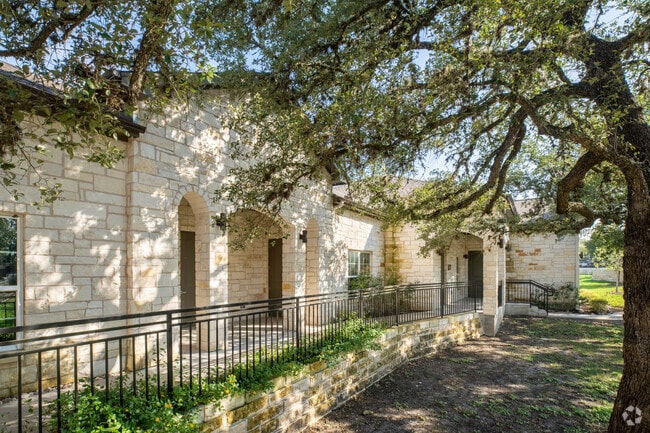
5915 La Crosse Ave, Austin, TX 78739


This Property Is For Sale
Current Lease Availabilities
Property Detail
5915 La Crosse Ave
Austin-Round Rock-San Marcos, TX
LOT 125B BLK RR CIRCLE C RANCH PHS B SEC 8-A AMD OF LOTS 125B&125C BLK RR
800323
Travis
Officebuilding
Texas
B and X Area of moderate flood hazard, usually the area between the limits of the 100-year and 500-year floods.
125b
2025
2.85 AC
2025
Southwest
036800
Austin
8,750 SF
NEARBY LISTINGS FOR SALE OR LEASE
DEMOGRAPHICS near 5915 La Crosse Ave
1 mile
3 mile
5 mile
2025 Total Population
7,689
61,989
151,747
2030 Population
7,840
63,823
157,698
Pop Growth 2025-2030
+ 1.96%
+ 2.96%
+ 3.92%
Average Age
39
40
40
2025 Total Households
2,445
23,406
61,170
HH Growth 2025-2030
+ 2.66%
+ 3.67%
+ 4.60%
Median Household Inc
$221,793
$146,816
$124,309
Avg Household Size
3.10
2.60
2.40
2025 Avg HH Vehicles
2.00
2.00
2.00
Median Home Value
$766,020
$702,498
$647,025
Median Year Built
1996
1997
1999
Nearby Places
Map Layers
Map Styles
 Street
 Aerial
Transit
 Traffic
 Biking
Places
Listings with unknown addresses are not visible on the map
- Restaurants
- Banks
- Shops
- Fitness
- Groceries
PUBLIC TRANSPORTATION
AIRPORT
Austin-Bergstrom International
Drive
Walk
Distance
Austin-Bergstrom International
30 min
17.6 mi
Freight Ports
Calhoun Port
Drive
Walk
Distance
Calhoun Port
191 min
159.1 mi
Nearby Properties
Address
Land Use
TOTAL SIZE
Lot Size
Zoning
Address
Land Use
TOTAL SIZE
Lot Size
Zoning
474,907 SF
36.94 AC
Address
Land Use
TOTAL SIZE
Lot Size
Zoning
441,209 SF
64.41 AC
Address
Land Use
TOTAL SIZE
Lot Size
Zoning
400,301 SF
22.65 AC
Address
Land Use
TOTAL SIZE
Lot Size
Zoning
258,600 SF
36.81 AC
Address
Land Use
TOTAL SIZE
Lot Size
Zoning
399,828 SF
50.10 AC
Address
Land Use
TOTAL SIZE
Lot Size
Zoning
327,886 SF
23.91 AC
Address
Land Use
TOTAL SIZE
Lot Size
Zoning
253,902 SF
28.21 AC
Address
Land Use
TOTAL SIZE
Lot Size
Zoning
345,632 SF
25.21 AC
Address
Land Use
TOTAL SIZE
Lot Size
Zoning
246,854 SF
19.40 AC
Address
Land Use
TOTAL SIZE
Lot Size
Zoning
240,640 SF
14.36 AC
Address
Land Use
TOTAL SIZE
Lot Size
Zoning
262,421 SF
33.65 AC
Address
Land Use
TOTAL SIZE
Lot Size
Zoning
126.95 AC
Address
Land Use
TOTAL SIZE
Lot Size
Zoning
82,326 SF
53.78 AC
Address
Land Use
TOTAL SIZE
Lot Size
Zoning
189,756 SF
28.77 AC
Address
Land Use
TOTAL SIZE
Lot Size
Zoning
253,404 SF
12.54 AC
Address
Land Use
TOTAL SIZE
Lot Size
Zoning
194,230 SF
11.25 AC
Address
Land Use
TOTAL SIZE
Lot Size
Zoning
90,244 SF
23.03 AC
Address
Land Use
TOTAL SIZE
Lot Size
Zoning
129,313 SF
7.45 AC
Address
Land Use
TOTAL SIZE
Lot Size
Zoning
134,076 SF
8.54 AC
Address
Land Use
TOTAL SIZE
Lot Size
Zoning
118,480 SF
5.16 AC
Address
Land Use
TOTAL SIZE
Lot Size
Zoning
119,556 SF
16.84 AC
Address
Land Use
TOTAL SIZE
Lot Size
Zoning
27.45 AC
Address
Land Use
TOTAL SIZE
Lot Size
Zoning
111,085 SF
14.17 AC
Address
Land Use
TOTAL SIZE
Lot Size
Zoning
102,256 SF
25.42 AC
Address
Land Use
TOTAL SIZE
Lot Size
Zoning
124,575 SF
11.99 AC
Address
Land Use
TOTAL SIZE
Lot Size
Zoning
144,732 SF
41.18 AC
Address
Land Use
TOTAL SIZE
Lot Size
Zoning
111,368 SF
9.95 AC
Address
Land Use
TOTAL SIZE
Lot Size
Zoning
71,124 SF
23.16 AC
Address
Land Use
TOTAL SIZE
Lot Size
Zoning
75,888 SF
25.97 AC
Address
Land Use
TOTAL SIZE
Lot Size
Zoning
107,798 SF
11.73 AC
The World's #1 Commercial Real Estate Marketplace
Connect with us
© 2026 CoStar Group
The information above has been obtained from sources believed reliable. While we do not doubt its accuracy we have not verified it and make no guarantee, warranty or representation about it. It is your responsibility to independently confirm its accuracy and completeness. Any projections, opinions, assumptions, or estimates used are for example only and do not represent the current or future performance of the property. The value of this transaction to you depends on tax and other factors which should be evaluated by your tax, financial, and legal advisors. You and your advisors should conduct a careful, independent investigation of the property to determine to your satisfaction the suitability of the property for your needs.