Property Record
5915 Maroons Blvd, Belleville, IL 62223
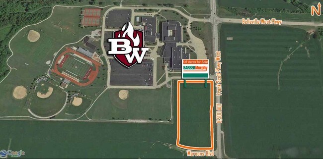
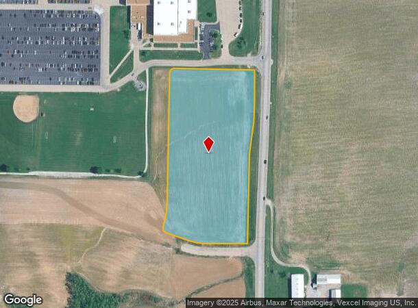
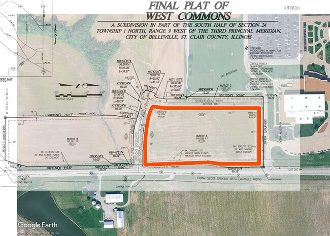
This Property Is For Sale
NEARBY LISTINGS FOR SALE OR LEASE
Property Detail
5915 Maroons Blvd
St. Louis
West Commons
St. Louis, MO-IL
WEST COMMONS OUTLOT A
07-24.0-400-009
St. Clair
Agriculturalland
Illinois
2024
6.61 AC
2024
Illinois
501605
DEMOGRAPHICS near 5915 Maroons Blvd
1 Mile
3 Mile
5 Mile
2024 Total Population
757
31,996
71,712
2029 Population
731
31,064
69,391
Pop Growth 2024-2029
(3.43%)
(2.91%)
(3.24%)
Average Age
45
42
42
2024 Total Households
324
13,948
30,763
HH Growth 2024-2029
(3.40%)
(2.94%)
(3.20%)
Median Household Inc
$79,963
$58,614
$68,443
Avg Household Size
2.30
2.20
2.20
2024 Avg HH Vehicles
2.00
2.00
2.00
Median Home Value
$166,504
$126,300
$149,010
Median Year Built
1969
1961
1966
Nearby Places
- Restaurants
- Banks
- Shops
- Fitness
- Groceries
PUBLIC TRANSPORTATION
COMMUTER RAIL
Memorial Hospital (Lambert Airport Shiloh-Scott - St. Louis MetroLink (MetroLink))
DRIVE
WALK
Distance
Memorial Hospital (Lambert Airport Shiloh-Scott - St. Louis MetroLink (MetroLink))
6 min
3.4 mi
Swansea (Lambert Airport Shiloh-Scott - St. Louis MetroLink (MetroLink))
DRIVE
WALK
Distance
Swansea (Lambert Airport Shiloh-Scott - St. Louis MetroLink (MetroLink))
10 min
5.9 mi
AIRPORT
Scott AFB/Midamerica St Louis
DRIVE
WALK
Distance
Scott AFB/Midamerica St Louis
28 min
14.8 mi
St Louis Lambert International
DRIVE
WALK
Distance
St Louis Lambert International
38 min
26.0 mi
Freight Ports
Port Milwaukee
DRIVE
WALK
Distance
Port Milwaukee
422 min
373.1 mi
Nearby Properties
Address
Land Use
TOTAL SIZE
Lot Size
Zoning
Address
Land Use
TOTAL SIZE
Lot Size
Zoning
20,522 SF
6.42 AC
Address
Land Use
TOTAL SIZE
Lot Size
Zoning
127,590 SF
10.53 AC
Address
Land Use
TOTAL SIZE
Lot Size
Zoning
18,734 SF
10.48 AC
Address
Land Use
TOTAL SIZE
Lot Size
Zoning
104,230 SF
11.08 AC
Address
Land Use
TOTAL SIZE
Lot Size
Zoning
Address
Land Use
TOTAL SIZE
Lot Size
Zoning
82,500 SF
14.61 AC
Address
Land Use
TOTAL SIZE
Lot Size
Zoning
49,248 SF
2 AC
Address
Land Use
TOTAL SIZE
Lot Size
Zoning
10,505 SF
20.08 AC
Address
Land Use
TOTAL SIZE
Lot Size
Zoning
6,800 SF
4.33 AC
Address
Land Use
TOTAL SIZE
Lot Size
Zoning
130,254 SF
11.44 AC
Address
Land Use
TOTAL SIZE
Lot Size
Zoning
13,546 SF
11.19 AC
Address
Land Use
TOTAL SIZE
Lot Size
Zoning
4,420 SF
3.82 AC
Address
Land Use
TOTAL SIZE
Lot Size
Zoning
15,839 SF
5.96 AC
Address
Land Use
TOTAL SIZE
Lot Size
Zoning
16,549 SF
5.44 AC
Address
Land Use
TOTAL SIZE
Lot Size
Zoning
54,179 SF
9.26 AC
Address
Land Use
TOTAL SIZE
Lot Size
Zoning
18.43 AC
Address
Land Use
TOTAL SIZE
Lot Size
Zoning
15,480 SF
1.35 AC
Address
Land Use
TOTAL SIZE
Lot Size
Zoning
23,951 SF
0.89 AC
Address
Land Use
TOTAL SIZE
Lot Size
Zoning
12,010 SF
2.49 AC
Address
Land Use
TOTAL SIZE
Lot Size
Zoning
47,369 SF
4.17 AC
Address
Land Use
TOTAL SIZE
Lot Size
Zoning
52,232 SF
4.06 AC
Address
Land Use
TOTAL SIZE
Lot Size
Zoning
30,779 SF
3.26 AC
Address
Land Use
TOTAL SIZE
Lot Size
Zoning
14,748 SF
1.78 AC
Address
Land Use
TOTAL SIZE
Lot Size
Zoning
2.98 AC
Address
Land Use
TOTAL SIZE
Lot Size
Zoning
6.65 AC
Address
Land Use
TOTAL SIZE
Lot Size
Zoning
68,968 SF
3.55 AC
Address
Land Use
TOTAL SIZE
Lot Size
Zoning
27,410 SF
2.64 AC
Address
Land Use
TOTAL SIZE
Lot Size
Zoning
13,028 SF
1.46 AC
Address
Land Use
TOTAL SIZE
Lot Size
Zoning
102,418 SF
9.70 AC
Address
Land Use
TOTAL SIZE
Lot Size
Zoning
12,950 SF
1.81 AC
The World's #1 Commercial Real Estate Marketplace
Connect with us
© 2025 CoStar Group
The information above has been obtained from sources believed reliable. While we do not doubt its accuracy we have not verified it and make no guarantee, warranty or representation about it. It is your responsibility to independently confirm its accuracy and completeness. Any projections, opinions, assumptions, or estimates used are for example only and do not represent the current or future performance of the property. The value of this transaction to you depends on tax and other factors which should be evaluated by your tax, financial, and legal advisors. You and your advisors should conduct a careful, independent investigation of the property to determine to your satisfaction the suitability of the property for your needs.