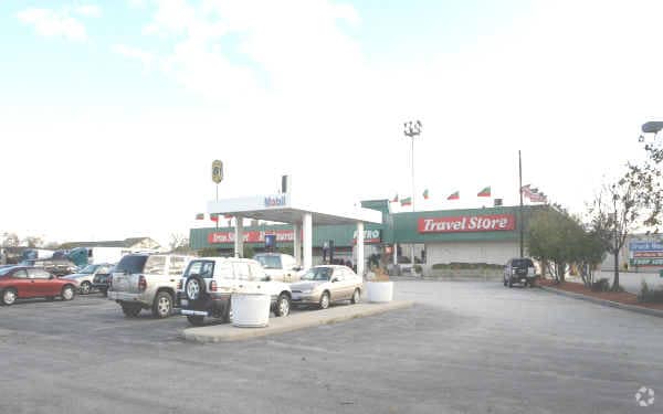
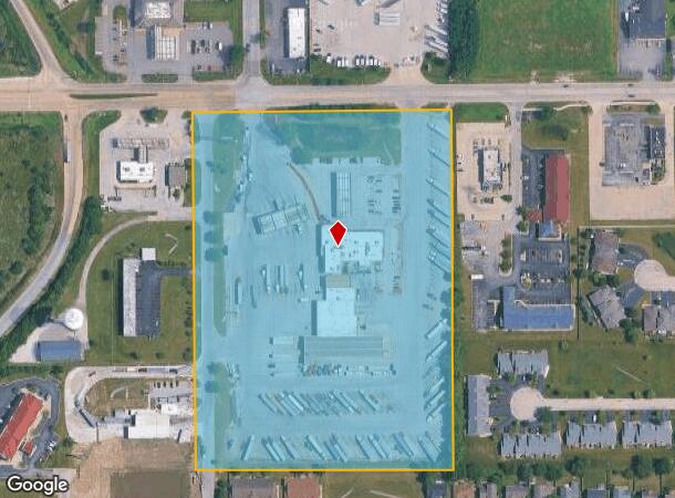
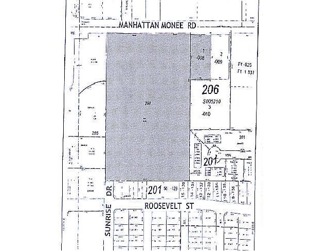
Property Record
5915 W Monee Manhattan Rd, Monee, IL 60449
NEARBY LISTINGS FOR SALE OR LEASE
Property Detail
5915 W Monee Manhattan Rd
21-14-20-200-014
Assessors Subdivision
Commercialnec
THE E 689.36 FT OF THE W 909.36 FT OF THE N 60 ACS OF THE NE 1/4 OF SEC 20, (EX THAT PRT TO THE STATE OF IL FOR RD PURPOSES P
X
Will
17197C0345G
Illinois
2024
14.56 AC
2024
Far South
883602
Chicago
28,217 SF
Chicago-Naperville-Elgin, IL-IN-WI
DEMOGRAPHICS near 5915 W Monee Manhattan Rd
1 Mile
3 Mile
5 Mile
2024 Total Population
2,126
7,616
40,946
2029 Population
2,129
7,575
40,718
Pop Growth 2024-2029
+ 0.14%
(0.54%)
(0.56%)
Average Age
44
43
40
2024 Total Households
895
2,896
15,358
HH Growth 2024-2029
+ 0.22%
(0.45%)
(0.87%)
Median Household Inc
$83,104
$85,278
$70,201
Avg Household Size
2.40
2.60
2.60
2024 Avg HH Vehicles
2.00
2.00
2.00
Median Home Value
$212,443
$238,278
$176,139
Median Year Built
1999
1998
1979
Nearby Places
Map Layers
Map Styles
 Street
 Aerial
- Restaurants
- Banks
- Shops
- Fitness
- Groceries
PUBLIC TRANSPORTATION
COMMUTER RAIL
University Park Station (Metra Electric Line - Northeast Illinois Regional Commuter Railroad (Metra))
DRIVE
WALK
Distance
University Park Station (Metra Electric Line - Northeast Illinois Regional Commuter Railroad (Metra))
6 min
3.4 mi
Richton Park Station (Metra Electric Line - Northeast Illinois Regional Commuter Railroad (Metra))
DRIVE
WALK
Distance
Richton Park Station (Metra Electric Line - Northeast Illinois Regional Commuter Railroad (Metra))
9 min
5.4 mi
AIRPORT
Chicago Midway International
DRIVE
WALK
Distance
Chicago Midway International
41 min
26.7 mi
Freight Ports
Port Milwaukee
DRIVE
WALK
Distance
Port Milwaukee
149 min
120.5 mi
Nearby Properties
Address
Land Use
TOTAL SIZE
Lot Size
Zoning
Address
Land Use
TOTAL SIZE
Lot Size
Zoning
65.63 AC
Address
Land Use
TOTAL SIZE
Lot Size
Zoning
990,000 SF
54.35 AC
Address
Land Use
TOTAL SIZE
Lot Size
Zoning
85.56 AC
Address
Land Use
TOTAL SIZE
Lot Size
Zoning
913,500 SF
54.87 AC
Address
Land Use
TOTAL SIZE
Lot Size
Zoning
575,024 SF
39.03 AC
Address
Land Use
TOTAL SIZE
Lot Size
Zoning
497,420 SF
35 AC
Address
Land Use
TOTAL SIZE
Lot Size
Zoning
718,777 SF
34.59 AC
Address
Land Use
TOTAL SIZE
Lot Size
Zoning
10.16 AC
Address
Land Use
TOTAL SIZE
Lot Size
Zoning
49.75 AC
Address
Land Use
TOTAL SIZE
Lot Size
Zoning
699,960 SF
31.34 AC
Address
Land Use
TOTAL SIZE
Lot Size
Zoning
650,160 SF
35.39 AC
Address
Land Use
TOTAL SIZE
Lot Size
Zoning
60.19 AC
Address
Land Use
TOTAL SIZE
Lot Size
Zoning
11.02 AC
Address
Land Use
TOTAL SIZE
Lot Size
Zoning
431,600 SF
23.98 AC
Address
Land Use
TOTAL SIZE
Lot Size
Zoning
715,732 SF
33.76 AC
Address
Land Use
TOTAL SIZE
Lot Size
Zoning
455,870 SF
23.32 AC
Address
Land Use
TOTAL SIZE
Lot Size
Zoning
458,858 SF
36.97 AC
Address
Land Use
TOTAL SIZE
Lot Size
Zoning
14,000 SF
12.99 AC
Address
Land Use
TOTAL SIZE
Lot Size
Zoning
Address
Land Use
TOTAL SIZE
Lot Size
Zoning
12.36 AC
Address
Land Use
TOTAL SIZE
Lot Size
Zoning
Address
Land Use
TOTAL SIZE
Lot Size
Zoning
142.91 AC
Address
Land Use
TOTAL SIZE
Lot Size
Zoning
70.02 AC
Address
Land Use
TOTAL SIZE
Lot Size
Zoning
8,920 SF
38.44 AC
Address
Land Use
TOTAL SIZE
Lot Size
Zoning
100,202 SF
2.90 AC
Address
Land Use
TOTAL SIZE
Lot Size
Zoning
5,000 SF
22.39 AC
Address
Land Use
TOTAL SIZE
Lot Size
Zoning
200,842 SF
8.61 AC
Address
Land Use
TOTAL SIZE
Lot Size
Zoning
266,177 SF
25 AC
Address
Land Use
TOTAL SIZE
Lot Size
Zoning
200,000 SF
12.59 AC
Address
Land Use
TOTAL SIZE
Lot Size
Zoning
242,130 SF
12.20 AC
The World's #1 Commercial Real Estate Marketplace
Connect with us
© 2026 CoStar Group
The information above has been obtained from sources believed reliable. While we do not doubt its accuracy we have not verified it and make no guarantee, warranty or representation about it. It is your responsibility to independently confirm its accuracy and completeness. Any projections, opinions, assumptions, or estimates used are for example only and do not represent the current or future performance of the property. The value of this transaction to you depends on tax and other factors which should be evaluated by your tax, financial, and legal advisors. You and your advisors should conduct a careful, independent investigation of the property to determine to your satisfaction the suitability of the property for your needs.