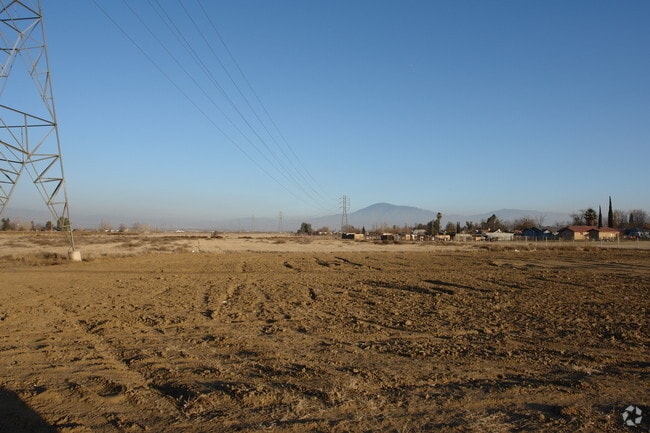
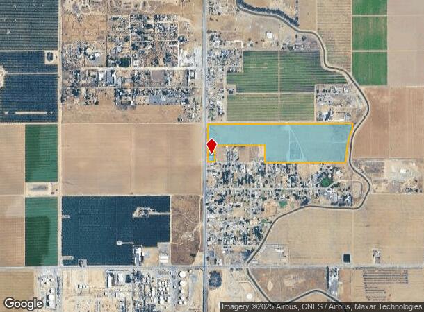
Property Record
5915 Weedpatch Hwy, Bakersfield, CA 93307


NEARBY LISTINGS FOR SALE OR LEASE
-
-
View all Bakersfield listings for sale on LoopNet.com
Property Detail
5915 Weedpatch Hwy
178-050-16-00-8
PARCEL MAP 202 , LOT D
Sfr
Kern
AO
California
06029C2325E
d
2024
35 AC
2025
SE Outlying Kern County
006201
Bakersfield
1,800 SF
Bakersfield-Delano, CA
DEMOGRAPHICS near 5915 Weedpatch Hwy
1 mile
3 mile
5 mile
2024 Total Population
1,119
11,310
55,253
2029 Population
1,112
11,233
55,197
Pop Growth 2024-2029
(0.63%)
(0.68%)
(0.10%)
Average Age
34
33
32
2024 Total Households
300
2,924
14,178
HH Growth 2024-2029
(0.67%)
(0.75%)
(0.18%)
Median Household Inc
$37,083
$39,362
$42,405
Avg Household Size
3.60
3.80
3.80
2024 Avg HH Vehicles
2.00
2.00
2.00
Median Home Value
$226,316
$271,474
$226,847
Median Year Built
1977
1972
1977
Nearby Places
Map Layers
Map Styles
 Street
 Aerial
Transit
 Traffic
 Biking
Places
Listings with unknown addresses are not visible on the map
- Restaurants
- Banks
- Shops
- Fitness
- Groceries
PUBLIC TRANSPORTATION
COMMUTER RAIL
Drive
Walk
Distance
17 min
9.7 mi
AIRPORT
Meadows Field
Drive
Walk
Distance
Meadows Field
28 min
17.7 mi
SALE & LEASE HISTORY
LISTING DATE
SALE/LEASE

May 22, 2025
For Sale
Nearby Properties
Address
Land Use
TOTAL SIZE
Lot Size
Zoning
Address
Land Use
TOTAL SIZE
Lot Size
Zoning
38.14 AC
M-3
Address
Land Use
TOTAL SIZE
Lot Size
Zoning
3,600 SF
18 AC
AG
Address
Land Use
TOTAL SIZE
Lot Size
Zoning
196.78 AC
A
Address
Land Use
TOTAL SIZE
Lot Size
Zoning
83.70 AC
A
Address
Land Use
TOTAL SIZE
Lot Size
Zoning
17,217 SF
1.52 AC
C2
Address
Land Use
TOTAL SIZE
Lot Size
Zoning
8,460 SF
4.08 AC
R2
Address
Land Use
TOTAL SIZE
Lot Size
Zoning
83.70 AC
A
Address
Land Use
TOTAL SIZE
Lot Size
Zoning
Address
Land Use
TOTAL SIZE
Lot Size
Zoning
72.55 AC
A
Address
Land Use
TOTAL SIZE
Lot Size
Zoning
71,134 SF
4.08 AC
Address
Land Use
TOTAL SIZE
Lot Size
Zoning
31,608 SF
2.68 AC
R-2
Address
Land Use
TOTAL SIZE
Lot Size
Zoning
153.69 AC
A
Address
Land Use
TOTAL SIZE
Lot Size
Zoning
2,682 SF
1.04 AC
C-2 FPS
Address
Land Use
TOTAL SIZE
Lot Size
Zoning
7,594 SF
79.09 AC
A
Address
Land Use
TOTAL SIZE
Lot Size
Zoning
9,100 SF
0.94 AC
C-2
Address
Land Use
TOTAL SIZE
Lot Size
Zoning
3,600 SF
4.61 AC
C2
Address
Land Use
TOTAL SIZE
Lot Size
Zoning
36.64 AC
A
Address
Land Use
TOTAL SIZE
Lot Size
Zoning
2,450 SF
0.69 AC
C2
Address
Land Use
TOTAL SIZE
Lot Size
Zoning
18.43 AC
A
Address
Land Use
TOTAL SIZE
Lot Size
Zoning
0.65 AC
C-2
Address
Land Use
TOTAL SIZE
Lot Size
Zoning
16,548 SF
3.03 AC
CO
Address
Land Use
TOTAL SIZE
Lot Size
Zoning
14.31 AC
Address
Land Use
TOTAL SIZE
Lot Size
Zoning
4,296 SF
0.70 AC
C-2
Address
Land Use
TOTAL SIZE
Lot Size
Zoning
5,622 SF
1.05 AC
C2 PD FPS
Address
Land Use
TOTAL SIZE
Lot Size
Zoning
11,524 SF
56.89 AC
A
Address
Land Use
TOTAL SIZE
Lot Size
Zoning
9,802 SF
0.64 AC
C2 FPS
Address
Land Use
TOTAL SIZE
Lot Size
Zoning
5,224 SF
5.38 AC
M2
Address
Land Use
TOTAL SIZE
Lot Size
Zoning
5.72 AC
A1
Address
Land Use
TOTAL SIZE
Lot Size
Zoning
6,761 SF
114.81 AC
A
Address
Land Use
TOTAL SIZE
Lot Size
Zoning
118.29 AC
A
The World's #1 Commercial Real Estate Marketplace
Connect with us
© 2026 CoStar Group
The information above has been obtained from sources believed reliable. While we do not doubt its accuracy we have not verified it and make no guarantee, warranty or representation about it. It is your responsibility to independently confirm its accuracy and completeness. Any projections, opinions, assumptions, or estimates used are for example only and do not represent the current or future performance of the property. The value of this transaction to you depends on tax and other factors which should be evaluated by your tax, financial, and legal advisors. You and your advisors should conduct a careful, independent investigation of the property to determine to your satisfaction the suitability of the property for your needs.