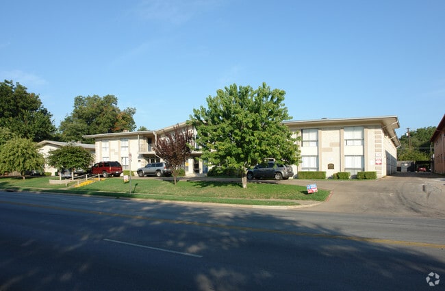
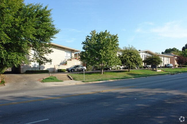
Property Record
5917 Gaston Ave, Dallas, TX 75214
NEARBY LISTINGS FOR SALE OR LEASE
Property Detail
5917 Gaston Ave
Dallas-Fort Worth-Arlington, TX
Munger Place Heights
00000183019000000
MUNGER PLACE HEIGHTS BLK 3/1882 LTS 4 & 5 INT201800007790 DD12262017 CO-DC 1882 003 00400 1001882 003
Apartment
Dallas
X
Texas
48113C0345J
4,5
2024
0.85 AC
2025
Old East Dallas
001400
Dallas/Ft Worth
22,520 SF
DEMOGRAPHICS near 5917 Gaston Ave
1 Mile
3 Mile
5 Mile
2024 Total Population
24,075
179,782
429,644
2029 Population
24,243
181,556
432,812
Pop Growth 2024-2029
+ 0.70%
+ 0.99%
+ 0.74%
Average Age
37
37
37
2024 Total Households
11,329
92,629
203,809
HH Growth 2024-2029
+ 0.71%
+ 1.12%
+ 0.85%
Median Household Inc
$79,963
$82,934
$71,559
Avg Household Size
2.10
1.90
2.00
2024 Avg HH Vehicles
2.00
1.00
1.00
Median Home Value
$497,146
$489,101
$450,068
Median Year Built
1964
1992
1986
Nearby Places
Map Layers
Map Styles
 Street
 Aerial
- Restaurants
- Banks
- Shops
- Fitness
- Groceries
PUBLIC TRANSPORTATION
COMMUTER RAIL
DRIVE
WALK
Distance
12 min
4.6 mi
DRIVE
WALK
Distance
15 min
6.4 mi
AIRPORT
Dallas Love Field
DRIVE
WALK
Distance
Dallas Love Field
19 min
7.4 mi
Dallas-Fort Worth International
DRIVE
WALK
Distance
Dallas-Fort Worth International
36 min
24.0 mi
Nearby Properties
Address
Land Use
TOTAL SIZE
Lot Size
Zoning
Address
Land Use
TOTAL SIZE
Lot Size
Zoning
1,634,356 SF
92.90 AC
Z421
Address
Land Use
TOTAL SIZE
Lot Size
Zoning
3,713,071 SF
9.94 AC
Address
Land Use
TOTAL SIZE
Lot Size
Zoning
1,676,176 SF
2.18 AC
Z239
Address
Land Use
TOTAL SIZE
Lot Size
Zoning
906,730 SF
3.09 AC
Z239
Address
Land Use
TOTAL SIZE
Lot Size
Zoning
858,872 SF
23.90 AC
Z421
Address
Land Use
TOTAL SIZE
Lot Size
Zoning
731,849 SF
3.13 AC
Z239
Address
Land Use
TOTAL SIZE
Lot Size
Zoning
1,291,660 SF
2.56 AC
Z248
Address
Land Use
TOTAL SIZE
Lot Size
Zoning
1,026,046 SF
2.89 AC
Z248
Address
Land Use
TOTAL SIZE
Lot Size
Zoning
100 SF
27.05 AC
Z421
Address
Land Use
TOTAL SIZE
Lot Size
Zoning
1,980,000 SF
2.57 AC
Z21
Address
Land Use
TOTAL SIZE
Lot Size
Zoning
763,198 SF
3.01 AC
Z248
Address
Land Use
TOTAL SIZE
Lot Size
Zoning
486,300 SF
1.55 AC
Z239
Address
Land Use
TOTAL SIZE
Lot Size
Zoning
906,627 SF
3.83 AC
Z239
Address
Land Use
TOTAL SIZE
Lot Size
Zoning
226,331 SF
1.12 AC
Address
Land Use
TOTAL SIZE
Lot Size
Zoning
536,874 SF
1.03 AC
Z239
Address
Land Use
TOTAL SIZE
Lot Size
Zoning
2,695,010 SF
8.69 AC
Z239
Address
Land Use
TOTAL SIZE
Lot Size
Zoning
545,752 SF
1.33 AC
Z239
Address
Land Use
TOTAL SIZE
Lot Size
Zoning
1,848,034 SF
2.29 AC
Z21
Address
Land Use
TOTAL SIZE
Lot Size
Zoning
551,032 SF
3.13 AC
Z239
Address
Land Use
TOTAL SIZE
Lot Size
Zoning
1,003,243 SF
2.07 AC
Z21
Address
Land Use
TOTAL SIZE
Lot Size
Zoning
763,340 SF
8.31 AC
Z165
Address
Land Use
TOTAL SIZE
Lot Size
Zoning
447,418 SF
5.69 AC
Z236
Address
Land Use
TOTAL SIZE
Lot Size
Zoning
539,723 SF
0.58 AC
Z239
Address
Land Use
TOTAL SIZE
Lot Size
Zoning
446,593 SF
0.93 AC
Address
Land Use
TOTAL SIZE
Lot Size
Zoning
3,398,834 SF
13.45 AC
Z151
Address
Land Use
TOTAL SIZE
Lot Size
Zoning
659,884 SF
5.77 AC
Z151
Address
Land Use
TOTAL SIZE
Lot Size
Zoning
432,919 SF
0.69 AC
Z21
Address
Land Use
TOTAL SIZE
Lot Size
Zoning
814,976 SF
8.72 AC
Z151
Address
Land Use
TOTAL SIZE
Lot Size
Zoning
801,209 SF
1.57 AC
Z239
Address
Land Use
TOTAL SIZE
Lot Size
Zoning
454,810 SF
5.80 AC
Z239
The World's #1 Commercial Real Estate Marketplace
Connect with us
© 2025 CoStar Group
The information above has been obtained from sources believed reliable. While we do not doubt its accuracy we have not verified it and make no guarantee, warranty or representation about it. It is your responsibility to independently confirm its accuracy and completeness. Any projections, opinions, assumptions, or estimates used are for example only and do not represent the current or future performance of the property. The value of this transaction to you depends on tax and other factors which should be evaluated by your tax, financial, and legal advisors. You and your advisors should conduct a careful, independent investigation of the property to determine to your satisfaction the suitability of the property for your needs.