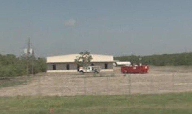
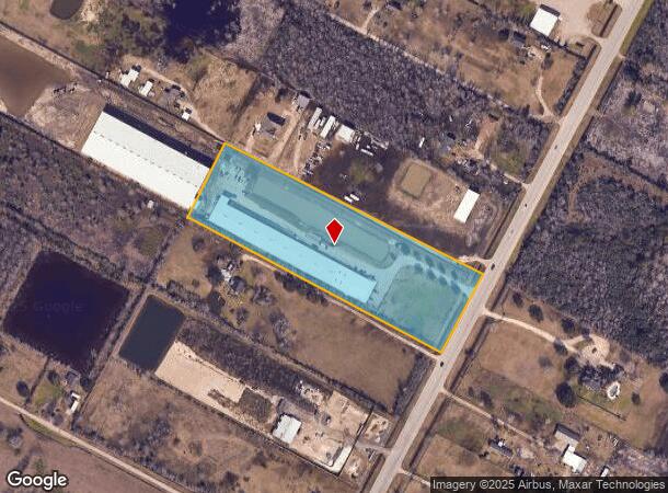
Property Record
5918 S Highway 35, Alvin, TX 77511
NEARBY LISTINGS FOR SALE OR LEASE
-
-
View all Alvin listings for sale on LoopNet.com
Property Detail
5918 S Highway 35
0072-0010-410
Wm Harris
Commercialnec
A0072 WM HARRIS TRACT 11P3 (CALLED TR 9) ACRES 5.00
X
Brazoria
48039C0285K
Texas
2024
5 AC
2025
Far South
661502
Houston
39,420 SF
Houston-The Woodlands-Sugar Land, TX
DEMOGRAPHICS near 5918 S Highway 35
1 Mile
3 Mile
5 Mile
2024 Total Population
534
6,456
33,263
2029 Population
589
7,148
36,989
Pop Growth 2024-2029
+ 10.30%
+ 10.72%
+ 11.20%
Average Age
40
38
38
2024 Total Households
185
2,160
12,057
HH Growth 2024-2029
+ 10.27%
+ 10.88%
+ 11.33%
Median Household Inc
$66,428
$71,410
$64,940
Avg Household Size
2.80
2.90
2.70
2024 Avg HH Vehicles
3.00
3.00
2.00
Median Home Value
$231,579
$229,032
$192,942
Median Year Built
1987
1989
1983
Nearby Places
Map Layers
Map Styles
 Street
 Aerial
- Restaurants
- Banks
- Shops
- Fitness
- Groceries
PUBLIC TRANSPORTATION
AIRPORT
William P Hobby
DRIVE
WALK
Distance
William P Hobby
39 min
22.3 mi
Freight Ports
Port of Houston
DRIVE
WALK
Distance
Port of Houston
50 min
30.4 mi
Nearby Properties
Address
Land Use
TOTAL SIZE
Lot Size
Zoning
Address
Land Use
TOTAL SIZE
Lot Size
Zoning
64,082 SF
17.62 AC
Address
Land Use
TOTAL SIZE
Lot Size
Zoning
108,386 SF
13 AC
Address
Land Use
TOTAL SIZE
Lot Size
Zoning
9,979 SF
5.37 AC
Address
Land Use
TOTAL SIZE
Lot Size
Zoning
61,432 SF
25 AC
Address
Land Use
TOTAL SIZE
Lot Size
Zoning
5,100 SF
17.17 AC
Address
Land Use
TOTAL SIZE
Lot Size
Zoning
62,104 SF
14.17 AC
Address
Land Use
TOTAL SIZE
Lot Size
Zoning
14,521 SF
54.99 AC
Address
Land Use
TOTAL SIZE
Lot Size
Zoning
374.51 AC
Address
Land Use
TOTAL SIZE
Lot Size
Zoning
10,640 SF
4.97 AC
Address
Land Use
TOTAL SIZE
Lot Size
Zoning
18,800 SF
12.96 AC
Address
Land Use
TOTAL SIZE
Lot Size
Zoning
26,960 SF
59.60 AC
0051
Address
Land Use
TOTAL SIZE
Lot Size
Zoning
62,446 SF
4.68 AC
Address
Land Use
TOTAL SIZE
Lot Size
Zoning
18,600 SF
55 AC
0017
Address
Land Use
TOTAL SIZE
Lot Size
Zoning
18,236 SF
16.28 AC
0034
Address
Land Use
TOTAL SIZE
Lot Size
Zoning
9,100 SF
1.82 AC
Address
Land Use
TOTAL SIZE
Lot Size
Zoning
15,600 SF
20.12 AC
0015
Address
Land Use
TOTAL SIZE
Lot Size
Zoning
17,030 SF
9.83 AC
0080
Address
Land Use
TOTAL SIZE
Lot Size
Zoning
85 SF
20 AC
0107
Address
Land Use
TOTAL SIZE
Lot Size
Zoning
12,160 SF
4 AC
Address
Land Use
TOTAL SIZE
Lot Size
Zoning
11,900 SF
20 AC
0030
Address
Land Use
TOTAL SIZE
Lot Size
Zoning
11,925 SF
4.98 AC
Address
Land Use
TOTAL SIZE
Lot Size
Zoning
5,871 SF
1.79 AC
Address
Land Use
TOTAL SIZE
Lot Size
Zoning
13,366 SF
7.08 AC
Address
Land Use
TOTAL SIZE
Lot Size
Zoning
512 SF
8.14 AC
0037
Address
Land Use
TOTAL SIZE
Lot Size
Zoning
9,045 SF
5.66 AC
Address
Land Use
TOTAL SIZE
Lot Size
Zoning
60.08 AC
0024
Address
Land Use
TOTAL SIZE
Lot Size
Zoning
26.84 AC
Address
Land Use
TOTAL SIZE
Lot Size
Zoning
9,269 SF
11.84 AC
Address
Land Use
TOTAL SIZE
Lot Size
Zoning
12,400 SF
1.15 AC
The World's #1 Commercial Real Estate Marketplace
Connect with us
© 2025 CoStar Group
The information above has been obtained from sources believed reliable. While we do not doubt its accuracy we have not verified it and make no guarantee, warranty or representation about it. It is your responsibility to independently confirm its accuracy and completeness. Any projections, opinions, assumptions, or estimates used are for example only and do not represent the current or future performance of the property. The value of this transaction to you depends on tax and other factors which should be evaluated by your tax, financial, and legal advisors. You and your advisors should conduct a careful, independent investigation of the property to determine to your satisfaction the suitability of the property for your needs.