Property Record
5918 W Courtyard Dr, Austin, TX 78730
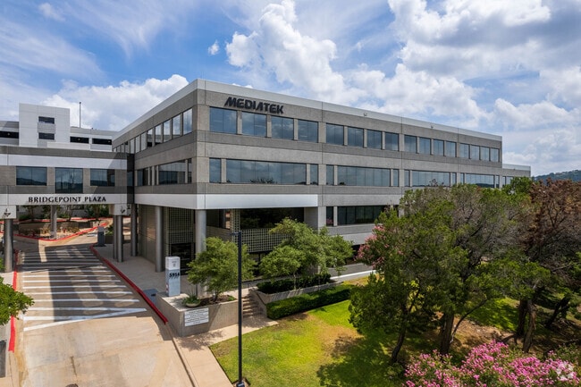

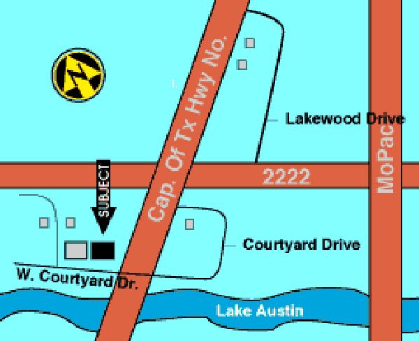

Property Detail
5918 W Courtyard Dr
Austin-Round Rock-San Marcos, TX
LOT 1 HIDDEN VALLEY PHS A
134340
TRAVIS
Officebuilding
Texas
B and X Area of moderate flood hazard, usually the area between the limits of the 100-year and 500-year floods.
1
2025
8.78 AC
2025
Northwest
032900
Austin
178,606 SF
NEARBY LISTINGS FOR SALE OR LEASE
DEMOGRAPHICS near 5918 W Courtyard Dr
1 mile
3 mile
5 mile
2025 Total Population
4,386
41,743
159,237
2030 Population
4,552
43,153
166,127
Pop Growth 2025-2030
+ 3.78%
+ 3.38%
+ 4.33%
Average Age
44
43
41
2025 Total Households
1,975
18,765
72,904
HH Growth 2025-2030
+ 4.41%
+ 4.02%
+ 5.14%
Median Household Inc
$178,764
$134,521
$114,809
Avg Household Size
2.20
2.20
2.10
2025 Avg HH Vehicles
2.00
2.00
2.00
Median Home Value
$1,060,375
$1,012,429
$913,783
Median Year Built
1994
1985
1986
Nearby Places
Map Layers
Map Styles
 Street
 Aerial
Layers
 Traffic
 Biking
Places
Listings with unknown addresses are not visible on the map
- Restaurants
- Banks
- Shops
- Fitness
- Groceries
PUBLIC TRANSPORTATION
COMMUTER RAIL
Austin (Texas Eagle - Amtrak)
Drive
Walk
Distance
Austin (Texas Eagle - Amtrak)
18 min
9.8 mi
AIRPORT
Austin-Bergstrom International
Drive
Walk
Distance
Austin-Bergstrom International
35 min
20.6 mi
Freight Ports
Calhoun Port
Drive
Walk
Distance
Calhoun Port
200 min
164.1 mi
SALE & LEASE HISTORY
LISTING DATE
SALE/LEASE

Sep 24, 2016
For Lease
Oct 01, 2024
For Lease
Nov 30, 2017
For Lease
May 02, 2023
For Lease
Jul 29, 2021
For Lease
Jul 26, 2018
For Lease
Nearby Properties
Address
Land Use
TOTAL SIZE
Lot Size
Zoning
Address
Land Use
TOTAL SIZE
Lot Size
Zoning
485,130 SF
28.07 AC
Address
Land Use
TOTAL SIZE
Lot Size
Zoning
133,092 SF
54.32 AC
Address
Land Use
TOTAL SIZE
Lot Size
Zoning
344,561 SF
41.25 AC
Address
Land Use
TOTAL SIZE
Lot Size
Zoning
332,202 SF
31.81 AC
Address
Land Use
TOTAL SIZE
Lot Size
Zoning
366,805 SF
23.78 AC
Address
Land Use
TOTAL SIZE
Lot Size
Zoning
349,535 SF
245.89 AC
Address
Land Use
TOTAL SIZE
Lot Size
Zoning
29.38 AC
Address
Land Use
TOTAL SIZE
Lot Size
Zoning
310,609 SF
51.42 AC
Address
Land Use
TOTAL SIZE
Lot Size
Zoning
560,549 SF
8.07 AC
Address
Land Use
TOTAL SIZE
Lot Size
Zoning
244,843 SF
30.56 AC
Address
Land Use
TOTAL SIZE
Lot Size
Zoning
232,960 SF
14.85 AC
Address
Land Use
TOTAL SIZE
Lot Size
Zoning
250,000 SF
9.22 AC
Address
Land Use
TOTAL SIZE
Lot Size
Zoning
290,297 SF
18.08 AC
Address
Land Use
TOTAL SIZE
Lot Size
Zoning
202,346 SF
16.50 AC
Address
Land Use
TOTAL SIZE
Lot Size
Zoning
364,095 SF
20.45 AC
Address
Land Use
TOTAL SIZE
Lot Size
Zoning
280,524 SF
30.38 AC
Address
Land Use
TOTAL SIZE
Lot Size
Zoning
62,578 SF
17.86 AC
Address
Land Use
TOTAL SIZE
Lot Size
Zoning
231,852 SF
11.26 AC
Address
Land Use
TOTAL SIZE
Lot Size
Zoning
174,806 SF
11.29 AC
Address
Land Use
TOTAL SIZE
Lot Size
Zoning
185,001 SF
10.82 AC
Address
Land Use
TOTAL SIZE
Lot Size
Zoning
112,455 SF
21.04 AC
Address
Land Use
TOTAL SIZE
Lot Size
Zoning
162,255 SF
8.78 AC
Address
Land Use
TOTAL SIZE
Lot Size
Zoning
173,387 SF
9.30 AC
Address
Land Use
TOTAL SIZE
Lot Size
Zoning
231,083 SF
28.79 AC
Address
Land Use
TOTAL SIZE
Lot Size
Zoning
246,300 SF
10 AC
Address
Land Use
TOTAL SIZE
Lot Size
Zoning
942.27 AC
Address
Land Use
TOTAL SIZE
Lot Size
Zoning
85,648 SF
22 AC
Address
Land Use
TOTAL SIZE
Lot Size
Zoning
161,364 SF
5.04 AC
Address
Land Use
TOTAL SIZE
Lot Size
Zoning
197,632 SF
9.64 AC
The World's #1 Commercial Real Estate Marketplace
Connect with us
© 2026 CoStar Group
The information above has been obtained from sources believed reliable. While we do not doubt its accuracy we have not verified it and make no guarantee, warranty or representation about it. It is your responsibility to independently confirm its accuracy and completeness. Any projections, opinions, assumptions, or estimates used are for example only and do not represent the current or future performance of the property. The value of this transaction to you depends on tax and other factors which should be evaluated by your tax, financial, and legal advisors. You and your advisors should conduct a careful, independent investigation of the property to determine to your satisfaction the suitability of the property for your needs.