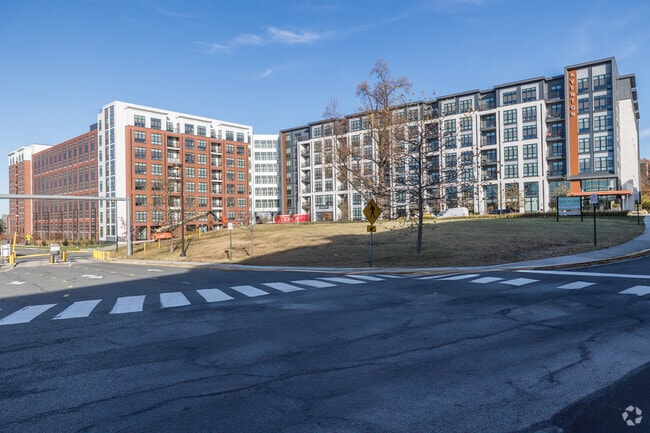
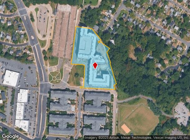
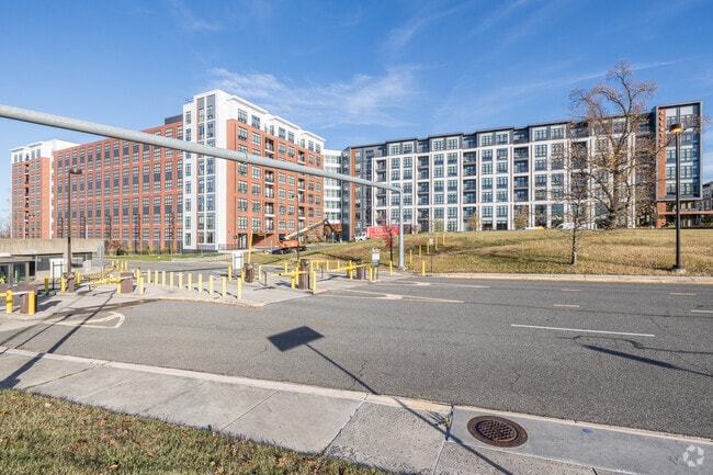
Property Record
5919 Ashlar Way, Alexandria, VA 22303
NEARBY LISTINGS FOR SALE OR LEASE
Property Detail
5919 Ashlar Way
Washington, DC
Huntington Metro
Washington-Arlington-Alexandria, DC-VA-MD-WV
HUNTINGTON METRO PCL C4
0833-38-C3
Fairfax
Apartment
Virginia
2024
c
2025
4.02 AC
420503
Huntington
400,372 SF
DEMOGRAPHICS near 5919 Ashlar Way
1 Mile
3 Mile
5 Mile
2024 Total Population
26,235
146,135
455,722
2029 Population
26,042
143,132
446,214
Pop Growth 2024-2029
(0.74%)
(2.05%)
(2.09%)
Average Age
39
40
39
2024 Total Households
12,819
65,084
195,346
HH Growth 2024-2029
(0.87%)
(2.14%)
(2.15%)
Median Household Inc
$111,233
$128,345
$105,553
Avg Household Size
2.00
2.20
2.30
2024 Avg HH Vehicles
1.00
2.00
1.00
Median Home Value
$572,861
$703,150
$583,844
Median Year Built
1987
1972
1974
Nearby Places
- Restaurants
- Banks
- Shops
- Fitness
- Groceries
PUBLIC TRANSPORTATION
TRANSIT/SUBWAY
Huntington (Yellow Line - Washington Metropolitan Area Transit Authority Metrorail (Metrorail))
DRIVE
WALK
Distance
Huntington (Yellow Line - Washington Metropolitan Area Transit Authority Metrorail (Metrorail))
4 min
8 min
0.4 mi
COMMUTER RAIL
DRIVE
WALK
Distance
6 min
1.9 mi
Alexandria (Fredericksburg Line - Virginia Railway Express, Manassas Line - Virginia Railway Express)
DRIVE
WALK
Distance
Alexandria (Fredericksburg Line - Virginia Railway Express, Manassas Line - Virginia Railway Express)
5 min
2.0 mi
AIRPORT
Ronald Reagan Washington Ntl
DRIVE
WALK
Distance
Ronald Reagan Washington Ntl
18 min
6.3 mi
Washington Dulles International
DRIVE
WALK
Distance
Washington Dulles International
52 min
32.7 mi
Baltimore/Washington International Thurgood Marshall
DRIVE
WALK
Distance
Baltimore/Washington International Thurgood Marshall
64 min
41.2 mi
Freight Ports
Port of Baltimore
DRIVE
WALK
Distance
Port of Baltimore
72 min
47.5 mi
Nearby Properties
Address
Land Use
TOTAL SIZE
Lot Size
Zoning
Address
Land Use
TOTAL SIZE
Lot Size
Zoning
75.49 AC
RA
Address
Land Use
TOTAL SIZE
Lot Size
Zoning
989,384 SF
5.17 AC
CDD#2
Address
Land Use
TOTAL SIZE
Lot Size
Zoning
1,563,434 SF
75.24 AC
220
Address
Land Use
TOTAL SIZE
Lot Size
Zoning
1,278,930 SF
28.17 AC
350
Address
Land Use
TOTAL SIZE
Lot Size
Zoning
360,007 SF
35.80 AC
UT
Address
Land Use
TOTAL SIZE
Lot Size
Zoning
336,904 SF
2.12 AC
CDD#15
Address
Land Use
TOTAL SIZE
Lot Size
Zoning
4,324 SF
1,261.53 AC
110
Address
Land Use
TOTAL SIZE
Lot Size
Zoning
782,494 SF
27.65 AC
R 12
Address
Land Use
TOTAL SIZE
Lot Size
Zoning
1,032,882 SF
CDD#20
Address
Land Use
TOTAL SIZE
Lot Size
Zoning
608,495 SF
1.50 AC
CDD#2
Address
Land Use
TOTAL SIZE
Lot Size
Zoning
1,178,900 SF
4.67 AC
CDD#1
Address
Land Use
TOTAL SIZE
Lot Size
Zoning
343,400 SF
12 AC
POS
Address
Land Use
TOTAL SIZE
Lot Size
Zoning
559,357 SF
2.26 AC
CDD#2
Address
Land Use
TOTAL SIZE
Lot Size
Zoning
499,532 SF
3.04 AC
Address
Land Use
TOTAL SIZE
Lot Size
Zoning
445,727 SF
12.82 AC
RC
Address
Land Use
TOTAL SIZE
Lot Size
Zoning
166,800 SF
2.72 AC
CDD#1
Address
Land Use
TOTAL SIZE
Lot Size
Zoning
315,876 SF
1.55 AC
OCH
Address
Land Use
TOTAL SIZE
Lot Size
Zoning
7.04 AC
CDD#3
Address
Land Use
TOTAL SIZE
Lot Size
Zoning
455,148 SF
6.60 AC
340
Address
Land Use
TOTAL SIZE
Lot Size
Zoning
608,362 SF
19.89 AC
R 20
Address
Land Use
TOTAL SIZE
Lot Size
Zoning
288,675 SF
2 AC
RM
Address
Land Use
TOTAL SIZE
Lot Size
Zoning
556,384 SF
2.59 AC
CRMU/H
Address
Land Use
TOTAL SIZE
Lot Size
Zoning
365,777 SF
4.79 AC
350
Address
Land Use
TOTAL SIZE
Lot Size
Zoning
358,188 SF
2.44 AC
CDD#1
Address
Land Use
TOTAL SIZE
Lot Size
Zoning
1.43 AC
CDD#1
Address
Land Use
TOTAL SIZE
Lot Size
Zoning
516,508 SF
3.35 AC
CDD#3
Address
Land Use
TOTAL SIZE
Lot Size
Zoning
54,000 SF
24.50 AC
350
Address
Land Use
TOTAL SIZE
Lot Size
Zoning
1.31 AC
CDD#2
The World's #1 Commercial Real Estate Marketplace
Connect with us
© 2025 CoStar Group
The information above has been obtained from sources believed reliable. While we do not doubt its accuracy we have not verified it and make no guarantee, warranty or representation about it. It is your responsibility to independently confirm its accuracy and completeness. Any projections, opinions, assumptions, or estimates used are for example only and do not represent the current or future performance of the property. The value of this transaction to you depends on tax and other factors which should be evaluated by your tax, financial, and legal advisors. You and your advisors should conduct a careful, independent investigation of the property to determine to your satisfaction the suitability of the property for your needs.