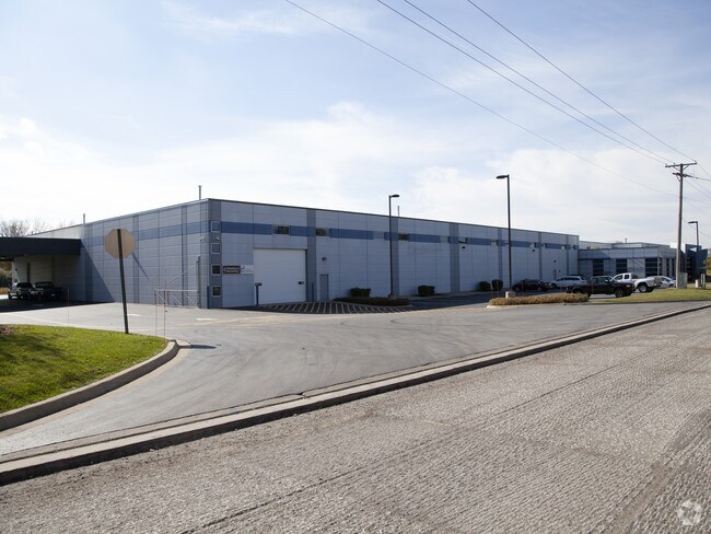
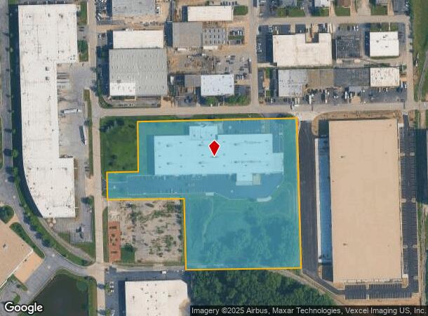
Property Record
5919 W 118Th St, Alsip, IL 60803

NEARBY LISTINGS FOR SALE OR LEASE
Property Detail
5919 W 118Th St
24-20-400-028-0000
Trainor Sub
Industrialgeneral
Cook
X
Illinois
17031C0617K
1,2
2023
8.59 AC
2024
Near South Cook
823200
Chicago
88,000 SF
Chicago-Naperville-Elgin, IL-IN-WI
DEMOGRAPHICS near 5919 W 118Th St
1 Mile
3 Mile
5 Mile
2024 Total Population
4,656
112,416
327,617
2029 Population
4,528
109,739
318,892
Pop Growth 2024-2029
(2.75%)
(2.38%)
(2.66%)
Average Age
44
42
41
2024 Total Households
1,771
44,863
122,774
HH Growth 2024-2029
(3.11%)
(2.63%)
(2.93%)
Median Household Inc
$80,198
$69,479
$72,753
Avg Household Size
2.50
2.40
2.60
2024 Avg HH Vehicles
2.00
2.00
2.00
Median Home Value
$248,214
$238,554
$240,672
Median Year Built
1974
1971
1968
Nearby Places
Map Layers
Map Styles
 Street
 Aerial
- Restaurants
- Banks
- Shops
- Fitness
- Groceries
PUBLIC TRANSPORTATION
COMMUTER RAIL
Worth Station (SouthWest Service - Northeast Illinois Regional Commuter Railroad (Metra))
DRIVE
WALK
Distance
Worth Station (SouthWest Service - Northeast Illinois Regional Commuter Railroad (Metra))
6 min
2.5 mi
Chicago Ridge Station (SouthWest Service - Northeast Illinois Regional Commuter Railroad (Metra))
DRIVE
WALK
Distance
Chicago Ridge Station (SouthWest Service - Northeast Illinois Regional Commuter Railroad (Metra))
6 min
2.5 mi
AIRPORT
Chicago Midway International
DRIVE
WALK
Distance
Chicago Midway International
20 min
10.2 mi
Chicago O'Hare International
DRIVE
WALK
Distance
Chicago O'Hare International
46 min
30.8 mi
Freight Ports
Port Milwaukee
DRIVE
WALK
Distance
Port Milwaukee
127 min
102.5 mi
Nearby Properties
Address
Land Use
TOTAL SIZE
Lot Size
Zoning
Address
Land Use
TOTAL SIZE
Lot Size
Zoning
13.59 AC
MU
Address
Land Use
TOTAL SIZE
Lot Size
Zoning
Address
Land Use
TOTAL SIZE
Lot Size
Zoning
23.81 AC
Address
Land Use
TOTAL SIZE
Lot Size
Zoning
48,792 SF
8.71 AC
RT-4
Address
Land Use
TOTAL SIZE
Lot Size
Zoning
191,763 SF
15.63 AC
Address
Land Use
TOTAL SIZE
Lot Size
Zoning
495,815 SF
20.78 AC
Address
Land Use
TOTAL SIZE
Lot Size
Zoning
101,169 SF
13.07 AC
Address
Land Use
TOTAL SIZE
Lot Size
Zoning
401,021 SF
27.42 AC
Address
Land Use
TOTAL SIZE
Lot Size
Zoning
421,052 SF
26.15 AC
Address
Land Use
TOTAL SIZE
Lot Size
Zoning
510,332 SF
23.97 AC
Address
Land Use
TOTAL SIZE
Lot Size
Zoning
5.66 AC
Address
Land Use
TOTAL SIZE
Lot Size
Zoning
34,970 SF
3.87 AC
Address
Land Use
TOTAL SIZE
Lot Size
Zoning
152,306 SF
13.40 AC
Address
Land Use
TOTAL SIZE
Lot Size
Zoning
96,469 SF
6.77 AC
Address
Land Use
TOTAL SIZE
Lot Size
Zoning
61,388 SF
2 AC
Address
Land Use
TOTAL SIZE
Lot Size
Zoning
185,748 SF
15.30 AC
Address
Land Use
TOTAL SIZE
Lot Size
Zoning
Address
Land Use
TOTAL SIZE
Lot Size
Zoning
405,045 SF
14.49 AC
Address
Land Use
TOTAL SIZE
Lot Size
Zoning
113,963 SF
10.55 AC
Address
Land Use
TOTAL SIZE
Lot Size
Zoning
869,275 SF
24.34 AC
Address
Land Use
TOTAL SIZE
Lot Size
Zoning
283,947 SF
13.27 AC
Address
Land Use
TOTAL SIZE
Lot Size
Zoning
320,038 SF
13.04 AC
Address
Land Use
TOTAL SIZE
Lot Size
Zoning
100,496 SF
9.96 AC
Address
Land Use
TOTAL SIZE
Lot Size
Zoning
127,984 SF
12.76 AC
Address
Land Use
TOTAL SIZE
Lot Size
Zoning
67,488 SF
10 AC
Address
Land Use
TOTAL SIZE
Lot Size
Zoning
261,520 SF
13.59 AC
Address
Land Use
TOTAL SIZE
Lot Size
Zoning
567,900 SF
15.07 AC
Address
Land Use
TOTAL SIZE
Lot Size
Zoning
43,271 SF
2.09 AC
Address
Land Use
TOTAL SIZE
Lot Size
Zoning
73,696 SF
6.43 AC
Address
Land Use
TOTAL SIZE
Lot Size
Zoning
9.38 AC
The World's #1 Commercial Real Estate Marketplace
Connect with us
© 2025 CoStar Group
The information above has been obtained from sources believed reliable. While we do not doubt its accuracy we have not verified it and make no guarantee, warranty or representation about it. It is your responsibility to independently confirm its accuracy and completeness. Any projections, opinions, assumptions, or estimates used are for example only and do not represent the current or future performance of the property. The value of this transaction to you depends on tax and other factors which should be evaluated by your tax, financial, and legal advisors. You and your advisors should conduct a careful, independent investigation of the property to determine to your satisfaction the suitability of the property for your needs.