Property Record
592 Gibbons Hwy, Wilton, NH 03086


NEARBY LISTINGS FOR SALE OR LEASE
-
-
View all Wilton listings for sale on LoopNet.com
Property Detail
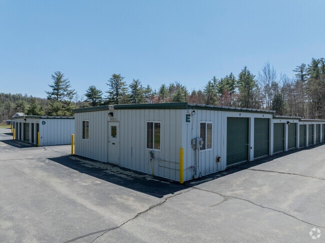
592 Gibbons Hwy
WLTN-000000-F000167
Hillsborough
Industrialgeneral
New Hampshire
AE
167
33011C0434D
6.50 AC
2024
Hillsborough
2024
Boston
019000
Manchester-Nashua, NH
DEMOGRAPHICS near 592 Gibbons Hwy
1 Mile
3 Mile
5 Mile
2024 Total Population
308
4,164
11,734
2029 Population
310
4,184
11,858
Pop Growth 2024-2029
+ 0.65%
+ 0.48%
+ 1.06%
Average Age
43
42
42
2024 Total Households
121
1,631
4,523
HH Growth 2024-2029
0.00%
+ 0.31%
+ 0.93%
Median Household Inc
$106,250
$104,984
$105,675
Avg Household Size
2.50
2.50
2.60
2024 Avg HH Vehicles
2.00
2.00
2.00
Median Home Value
$393,181
$373,262
$355,927
Median Year Built
1978
1974
1980
Nearby Places
Map Layers
Map Styles
 Street
 Aerial
- Restaurants
- Banks
- Shops
- Fitness
- Groceries
PUBLIC TRANSPORTATION
AIRPORT
Manchester Boston Regional
DRIVE
WALK
Distance
Manchester Boston Regional
46 min
26.1 mi
Freight Ports
Port of Boston
DRIVE
WALK
Distance
Port of Boston
98 min
67.0 mi
Nearby Properties
Address
Land Use
TOTAL SIZE
Lot Size
Zoning
Address
Land Use
TOTAL SIZE
Lot Size
Zoning
28 AC
RESIDE
Address
Land Use
TOTAL SIZE
Lot Size
Zoning
87,438 SF
55.60 AC
SZ
Address
Land Use
TOTAL SIZE
Lot Size
Zoning
127,722 SF
23.87 AC
I
Address
Land Use
TOTAL SIZE
Lot Size
Zoning
46.81 AC
RA
Address
Land Use
TOTAL SIZE
Lot Size
Zoning
45,690 SF
5.50 AC
Address
Land Use
TOTAL SIZE
Lot Size
Zoning
37,157 SF
1.60 AC
RA
Address
Land Use
TOTAL SIZE
Lot Size
Zoning
74.45 AC
RA
Address
Land Use
TOTAL SIZE
Lot Size
Zoning
6,000 SF
6.38 AC
ICI
Address
Land Use
TOTAL SIZE
Lot Size
Zoning
112,299 SF
3.50 AC
I
Address
Land Use
TOTAL SIZE
Lot Size
Zoning
10.10 AC
I
Address
Land Use
TOTAL SIZE
Lot Size
Zoning
29,404 SF
1.40 AC
I
Address
Land Use
TOTAL SIZE
Lot Size
Zoning
15,426 SF
6.40 AC
RA
Address
Land Use
TOTAL SIZE
Lot Size
Zoning
15.50 AC
RA
Address
Land Use
TOTAL SIZE
Lot Size
Zoning
8,940 SF
1.22 AC
ICI
Address
Land Use
TOTAL SIZE
Lot Size
Zoning
Address
Land Use
TOTAL SIZE
Lot Size
Zoning
6,000 SF
5.10 AC
I
Address
Land Use
TOTAL SIZE
Lot Size
Zoning
2,992 SF
2.12 AC
ICI
Address
Land Use
TOTAL SIZE
Lot Size
Zoning
20.30 AC
RA
Address
Land Use
TOTAL SIZE
Lot Size
Zoning
23,232 SF
Address
Land Use
TOTAL SIZE
Lot Size
Zoning
6.33 AC
I
Address
Land Use
TOTAL SIZE
Lot Size
Zoning
15,702 SF
0.90 AC
SZ
Address
Land Use
TOTAL SIZE
Lot Size
Zoning
Address
Land Use
TOTAL SIZE
Lot Size
Zoning
9,266 SF
0.88 AC
RD
Address
Land Use
TOTAL SIZE
Lot Size
Zoning
21.50 AC
RA
Address
Land Use
TOTAL SIZE
Lot Size
Zoning
44,774 SF
1.33 AC
I
Address
Land Use
TOTAL SIZE
Lot Size
Zoning
2.10 AC
RD
Address
Land Use
TOTAL SIZE
Lot Size
Zoning
10,364 SF
0.30 AC
RD
Address
Land Use
TOTAL SIZE
Lot Size
Zoning
46,146 SF
2.30 AC
I
Address
Land Use
TOTAL SIZE
Lot Size
Zoning
8,520 SF
0.80 AC
RD
The World's #1 Commercial Real Estate Marketplace
Connect with us
© 2026 CoStar Group
The information above has been obtained from sources believed reliable. While we do not doubt its accuracy we have not verified it and make no guarantee, warranty or representation about it. It is your responsibility to independently confirm its accuracy and completeness. Any projections, opinions, assumptions, or estimates used are for example only and do not represent the current or future performance of the property. The value of this transaction to you depends on tax and other factors which should be evaluated by your tax, financial, and legal advisors. You and your advisors should conduct a careful, independent investigation of the property to determine to your satisfaction the suitability of the property for your needs.