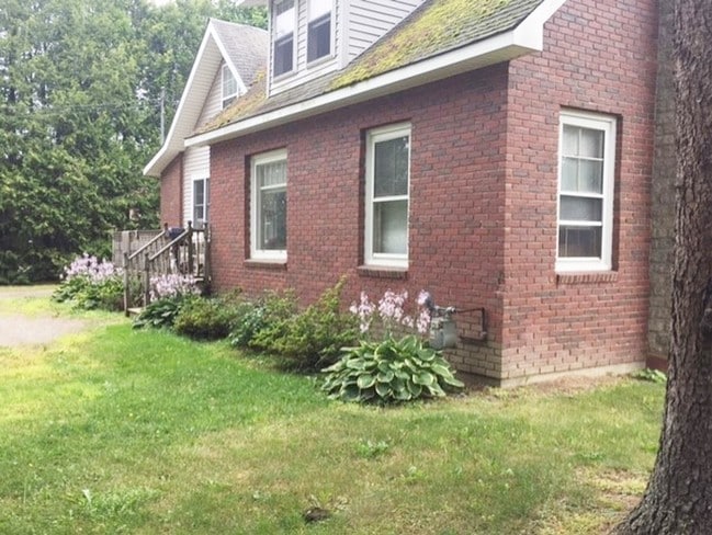
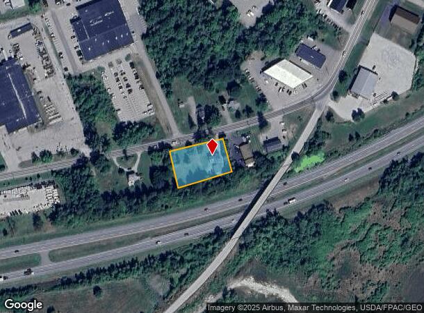
Property Record
592 Odlin Rd, Bangor, ME 04401

Property Detail
592 Odlin Rd
R18-012
Penobscot
Telephonefacility
Maine
X
12
23019C2114D
0.70 AC
2024
Maine North & Bangor
2024
Other Market Areas
000700
Bangor, ME
1,511 SF
NEARBY LISTINGS FOR SALE OR LEASE
DEMOGRAPHICS near 592 Odlin Rd
1 mile
3 mile
5 mile
2024 Total Population
65
21,980
50,792
2029 Population
67
22,580
52,079
Pop Growth 2024-2029
+ 3.08%
+ 2.73%
+ 2.53%
Average Age
44
43
42
2024 Total Households
26
10,372
22,786
HH Growth 2024-2029
+ 3.85%
+ 2.95%
+ 2.67%
Median Household Inc
$71,249
$51,401
$55,793
Avg Household Size
2.20
2.00
2.10
2024 Avg HH Vehicles
2.00
1.00
2.00
Median Home Value
$222,222
$197,463
$211,823
Median Year Built
1964
1956
1967
Nearby Places
Map Layers
Map Styles
 Street
 Aerial
Transit
 Traffic
 Biking
Places
Listings with unknown addresses are not visible on the map
- Restaurants
- Banks
- Shops
- Fitness
- Groceries
PUBLIC TRANSPORTATION
AIRPORT
Bangor International
Drive
Walk
Distance
Bangor International
8 min
2.9 mi
Freight Ports
Searsport, ME
Drive
Walk
Distance
Searsport, ME
49 min
31.9 mi
SALE & LEASE HISTORY
LISTING DATE
SALE/LEASE

Aug 24, 2017
For Sale
Nearby Properties
Address
Land Use
TOTAL SIZE
Lot Size
Zoning
Address
Land Use
TOTAL SIZE
Lot Size
Zoning
466.65 AC
ADD
Address
Land Use
TOTAL SIZE
Lot Size
Zoning
186,220 SF
93.91 AC
G&SD
Address
Land Use
TOTAL SIZE
Lot Size
Zoning
609,180 SF
6.68 AC
USD
Address
Land Use
TOTAL SIZE
Lot Size
Zoning
Address
Land Use
TOTAL SIZE
Lot Size
Zoning
6.37 AC
UID
Address
Land Use
TOTAL SIZE
Lot Size
Zoning
243,694 SF
2.95 AC
G&ISD
Address
Land Use
TOTAL SIZE
Lot Size
Zoning
54,122 SF
82.18 AC
12 - R
Address
Land Use
TOTAL SIZE
Lot Size
Zoning
87,750 SF
ADD
Address
Land Use
TOTAL SIZE
Lot Size
Zoning
400 SF
3.44 AC
WDD
Address
Land Use
TOTAL SIZE
Lot Size
Zoning
100,800 SF
1.34 AC
DDD
Address
Land Use
TOTAL SIZE
Lot Size
Zoning
12,950 SF
23.39 AC
31 - I
Address
Land Use
TOTAL SIZE
Lot Size
Zoning
168,615 SF
19.44 AC
MDR-1
Address
Land Use
TOTAL SIZE
Lot Size
Zoning
38 AC
G&ISD
Address
Land Use
TOTAL SIZE
Lot Size
Zoning
Address
Land Use
TOTAL SIZE
Lot Size
Zoning
115,044 SF
13.30 AC
G&ISD
Address
Land Use
TOTAL SIZE
Lot Size
Zoning
184,000 SF
16.43 AC
31 - I
Address
Land Use
TOTAL SIZE
Lot Size
Zoning
110,031 SF
3.81 AC
GC&S
Address
Land Use
TOTAL SIZE
Lot Size
Zoning
119,930 SF
9.50 AC
S&PS
Address
Land Use
TOTAL SIZE
Lot Size
Zoning
144,000 SF
111.04 AC
32 - I
Address
Land Use
TOTAL SIZE
Lot Size
Zoning
109,507 SF
1.96 AC
G&ISD
Address
Land Use
TOTAL SIZE
Lot Size
Zoning
7 AC
WDD
Address
Land Use
TOTAL SIZE
Lot Size
Zoning
43.96 AC
Address
Land Use
TOTAL SIZE
Lot Size
Zoning
111,000 SF
18.87 AC
HDR
Address
Land Use
TOTAL SIZE
Lot Size
Zoning
32,570 SF
1.38 AC
G&ISD
Address
Land Use
TOTAL SIZE
Lot Size
Zoning
246,766 SF
22.44 AC
S&PS
Address
Land Use
TOTAL SIZE
Lot Size
Zoning
13.58 AC
Address
Land Use
TOTAL SIZE
Lot Size
Zoning
72,720 SF
14.11 AC
HDR
Address
Land Use
TOTAL SIZE
Lot Size
Zoning
39.32 AC
CB
Address
Land Use
TOTAL SIZE
Lot Size
Zoning
69,703 SF
7.92 AC
USD
Address
Land Use
TOTAL SIZE
Lot Size
Zoning
2.50 AC
IND
The World's #1 Commercial Real Estate Marketplace
Connect with us
© 2026 CoStar Group
The information above has been obtained from sources believed reliable. While we do not doubt its accuracy we have not verified it and make no guarantee, warranty or representation about it. It is your responsibility to independently confirm its accuracy and completeness. Any projections, opinions, assumptions, or estimates used are for example only and do not represent the current or future performance of the property. The value of this transaction to you depends on tax and other factors which should be evaluated by your tax, financial, and legal advisors. You and your advisors should conduct a careful, independent investigation of the property to determine to your satisfaction the suitability of the property for your needs.