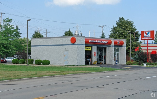
Property Record
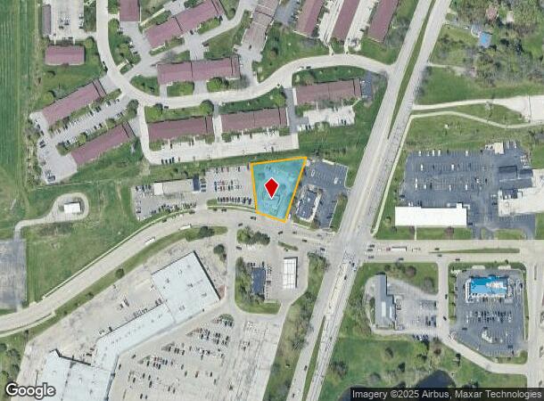
5920 21St St, Racine, WI 53406

NEARBY LISTINGS FOR SALE OR LEASE
Property Detail
5920 21St St
276-000023926001
NW 1/4 SECTION 24-3-22 BEG W 1/4 COR SD SEC, N 01 DEG W 198.51 FT ALG WLN SD SEC, N 81 DEG E 244.26 FT, N 08 DEG W 141.22 FT
Autorepair
Racine
X
Wisconsin
55101C0228D
0.55 AC
2024
Racine East
2024
Milwaukee/Madison
001701
Racine, WI
1,487 SF
DEMOGRAPHICS near 5920 21St St
1 Mile
3 Mile
5 Mile
2024 Total Population
6,684
68,200
118,407
2029 Population
6,639
67,562
117,594
Pop Growth 2024-2029
(0.67%)
(0.94%)
(0.69%)
Average Age
42
41
40
2024 Total Households
3,093
27,746
47,683
HH Growth 2024-2029
(0.58%)
(0.93%)
(0.73%)
Median Household Inc
$46,312
$63,227
$60,779
Avg Household Size
2.00
2.30
2.30
2024 Avg HH Vehicles
1.00
2.00
2.00
Median Home Value
$165,728
$178,118
$180,750
Median Year Built
1973
1966
1962
Nearby Places
Map Layers
Map Styles
 Street
 Aerial
- Restaurants
- Banks
- Shops
- Fitness
- Groceries
PUBLIC TRANSPORTATION
COMMUTER RAIL
Sturtevant Amtrak Station (Hiawatha Service - Amtrak)
DRIVE
WALK
Distance
Sturtevant Amtrak Station (Hiawatha Service - Amtrak)
9 min
4.8 mi
AIRPORT
General Mitchell International
DRIVE
WALK
Distance
General Mitchell International
32 min
23.8 mi
Freight Ports
Port Milwaukee
DRIVE
WALK
Distance
Port Milwaukee
37 min
27.7 mi
Nearby Properties
Address
Land Use
TOTAL SIZE
Lot Size
Zoning
Address
Land Use
TOTAL SIZE
Lot Size
Zoning
318.64 AC
Address
Land Use
TOTAL SIZE
Lot Size
Zoning
22.34 AC
Address
Land Use
TOTAL SIZE
Lot Size
Zoning
9.40 AC
B-3
Address
Land Use
TOTAL SIZE
Lot Size
Zoning
47.01 AC
M-1
Address
Land Use
TOTAL SIZE
Lot Size
Zoning
61,744 SF
42.23 AC
OI
Address
Land Use
TOTAL SIZE
Lot Size
Zoning
57.80 AC
M1
Address
Land Use
TOTAL SIZE
Lot Size
Zoning
9.31 AC
Address
Land Use
TOTAL SIZE
Lot Size
Zoning
30.45 AC
002
Address
Land Use
TOTAL SIZE
Lot Size
Zoning
19.29 AC
002
Address
Land Use
TOTAL SIZE
Lot Size
Zoning
5.74 AC
Address
Land Use
TOTAL SIZE
Lot Size
Zoning
Address
Land Use
TOTAL SIZE
Lot Size
Zoning
Address
Land Use
TOTAL SIZE
Lot Size
Zoning
22.98 AC
M-1
Address
Land Use
TOTAL SIZE
Lot Size
Zoning
32.99 AC
002
Address
Land Use
TOTAL SIZE
Lot Size
Zoning
19.77 AC
B-3
Address
Land Use
TOTAL SIZE
Lot Size
Zoning
Address
Land Use
TOTAL SIZE
Lot Size
Zoning
6.77 AC
PUL
Address
Land Use
TOTAL SIZE
Lot Size
Zoning
16.91 AC
Address
Land Use
TOTAL SIZE
Lot Size
Zoning
15.81 AC
Address
Land Use
TOTAL SIZE
Lot Size
Zoning
24.04 AC
BP
Address
Land Use
TOTAL SIZE
Lot Size
Zoning
0.11 AC
B-3
Address
Land Use
TOTAL SIZE
Lot Size
Zoning
33.40 AC
I2
Address
Land Use
TOTAL SIZE
Lot Size
Zoning
10.02 AC
Address
Land Use
TOTAL SIZE
Lot Size
Zoning
98.81 AC
Address
Land Use
TOTAL SIZE
Lot Size
Zoning
Address
Land Use
TOTAL SIZE
Lot Size
Zoning
164,201 SF
17 AC
B2
Address
Land Use
TOTAL SIZE
Lot Size
Zoning
Address
Land Use
TOTAL SIZE
Lot Size
Zoning
2.10 AC
Address
Land Use
TOTAL SIZE
Lot Size
Zoning
Address
Land Use
TOTAL SIZE
Lot Size
Zoning
76.18 AC
The World's #1 Commercial Real Estate Marketplace
Connect with us
© 2025 CoStar Group
The information above has been obtained from sources believed reliable. While we do not doubt its accuracy we have not verified it and make no guarantee, warranty or representation about it. It is your responsibility to independently confirm its accuracy and completeness. Any projections, opinions, assumptions, or estimates used are for example only and do not represent the current or future performance of the property. The value of this transaction to you depends on tax and other factors which should be evaluated by your tax, financial, and legal advisors. You and your advisors should conduct a careful, independent investigation of the property to determine to your satisfaction the suitability of the property for your needs.