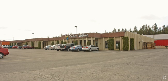
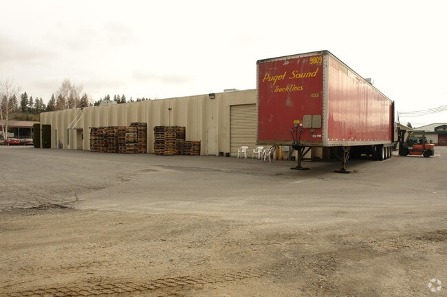
Property Record
5920 E Seltice Way, Post Falls, ID 83854

Property Detail
5920 E Seltice Way
P00000056050
TAX #12269 [IN SW] 0550N04W
Manufacturinglight
Kootenai
B and X Area of moderate flood hazard, usually the area between the limits of the 100-year and 500-year floods.
Idaho
2025
1.99 AC
2025
Greater Coeur D'Alene
000601
Coeur D'Alene
30,000 SF
Coeur d'Alene, ID
NEARBY LISTINGS FOR SALE OR LEASE
DEMOGRAPHICS near 5920 E Seltice Way
1 mile
3 mile
5 mile
2025 Total Population
3,358
39,744
102,576
2030 Population
3,523
41,857
107,681
Pop Growth 2025-2030
+ 4.91%
+ 5.32%
+ 4.98%
Average Age
45
41
40
2025 Total Households
1,304
15,561
40,769
HH Growth 2025-2030
+ 4.98%
+ 5.45%
+ 5.07%
Median Household Inc
$60,500
$68,760
$68,441
Avg Household Size
2.50
2.50
2.40
2025 Avg HH Vehicles
2.00
2.00
2.00
Median Home Value
$643,436
$563,038
$506,687
Median Year Built
1997
2000
1998
Nearby Places
Map Layers
Map Styles
 Street
 Aerial
Transit
 Traffic
 Biking
Places
Listings with unknown addresses are not visible on the map
- Restaurants
- Banks
- Shops
- Fitness
- Groceries
PUBLIC TRANSPORTATION
AIRPORT
Spokane International
Drive
Walk
Distance
Spokane International
44 min
34.0 mi
SALE & LEASE HISTORY
LISTING DATE
SALE/LEASE

Oct 15, 2020
For Lease
Nearby Properties
Address
Land Use
TOTAL SIZE
Lot Size
Zoning
Address
Land Use
TOTAL SIZE
Lot Size
Zoning
135,646 SF
18.40 AC
Address
Land Use
TOTAL SIZE
Lot Size
Zoning
117,842 SF
13.36 AC
AG
Address
Land Use
TOTAL SIZE
Lot Size
Zoning
32,132 SF
9.24 AC
Address
Land Use
TOTAL SIZE
Lot Size
Zoning
320,505 SF
60.51 AC
Address
Land Use
TOTAL SIZE
Lot Size
Zoning
177,574 SF
8.44 AC
Address
Land Use
TOTAL SIZE
Lot Size
Zoning
931 SF
16.15 AC
Address
Land Use
TOTAL SIZE
Lot Size
Zoning
138,614 SF
12.25 AC
Address
Land Use
TOTAL SIZE
Lot Size
Zoning
88,780 SF
8.23 AC
Address
Land Use
TOTAL SIZE
Lot Size
Zoning
96,132 SF
8.13 AC
Address
Land Use
TOTAL SIZE
Lot Size
Zoning
130,710 SF
8.23 AC
Address
Land Use
TOTAL SIZE
Lot Size
Zoning
144,970 SF
11.39 AC
Address
Land Use
TOTAL SIZE
Lot Size
Zoning
57,936 SF
7.88 AC
Address
Land Use
TOTAL SIZE
Lot Size
Zoning
265,175 SF
13.74 AC
Address
Land Use
TOTAL SIZE
Lot Size
Zoning
116,728 SF
6.48 AC
Address
Land Use
TOTAL SIZE
Lot Size
Zoning
59,629 SF
5.37 AC
Address
Land Use
TOTAL SIZE
Lot Size
Zoning
110,520 SF
4.68 AC
Address
Land Use
TOTAL SIZE
Lot Size
Zoning
112,154 SF
4.61 AC
Address
Land Use
TOTAL SIZE
Lot Size
Zoning
91,220 SF
4.66 AC
Address
Land Use
TOTAL SIZE
Lot Size
Zoning
104,855 SF
4.71 AC
Address
Land Use
TOTAL SIZE
Lot Size
Zoning
118,990 SF
5.66 AC
Address
Land Use
TOTAL SIZE
Lot Size
Zoning
94,193 SF
18.10 AC
AGSUB
Address
Land Use
TOTAL SIZE
Lot Size
Zoning
98,397 SF
4.70 AC
Address
Land Use
TOTAL SIZE
Lot Size
Zoning
99,645 SF
24 AC
Address
Land Use
TOTAL SIZE
Lot Size
Zoning
192,335 SF
18.20 AC
Address
Land Use
TOTAL SIZE
Lot Size
Zoning
57,936 SF
5.28 AC
Address
Land Use
TOTAL SIZE
Lot Size
Zoning
115,041 SF
4 AC
Address
Land Use
TOTAL SIZE
Lot Size
Zoning
59,912 SF
10.06 AC
COM
Address
Land Use
TOTAL SIZE
Lot Size
Zoning
106,656 SF
4.60 AC
Address
Land Use
TOTAL SIZE
Lot Size
Zoning
75,694 SF
3.68 AC
Address
Land Use
TOTAL SIZE
Lot Size
Zoning
63,432 SF
7.29 AC
The World's #1 Commercial Real Estate Marketplace
Connect with us
© 2026 CoStar Group
The information above has been obtained from sources believed reliable. While we do not doubt its accuracy we have not verified it and make no guarantee, warranty or representation about it. It is your responsibility to independently confirm its accuracy and completeness. Any projections, opinions, assumptions, or estimates used are for example only and do not represent the current or future performance of the property. The value of this transaction to you depends on tax and other factors which should be evaluated by your tax, financial, and legal advisors. You and your advisors should conduct a careful, independent investigation of the property to determine to your satisfaction the suitability of the property for your needs.